
Lêer:Carte des croisades avec participation des Français.png

Oorspronklike lêer (1 997 × 1 188 piksels, lêergrootte: 1,65 MG, MIME-tipe: image/png)
Opsomming
| Beskrywing |
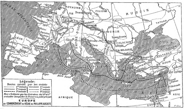
Deutsch: Karte der sechs mittelalterlichen Kreuzzüge, an denen die Franzosen teilgenommen haben, Larousse universel, 1922.
English: Map of the six medieval crusades in which the French participated, from Larousse universel, 1922.
Français : Carte des six croisades médiévales auxquelles les Français ont participé, Larousse universel en deux volumes, 1922. |
| Datum | |
| Bron | Scan from the Larousse 1922 by Nataraja-Shiva, also available on Gallica |
| Outeur | Larousse |
Lisensiëring
|
This work is in the public domain in its country of origin and other countries and areas where the copyright term is the author's life plus 70 years or fewer.
| |
| Hierdie lêer is geïdentifiseer as vry van bekende beperkings onder kopiereg, insluitend alle verwante en naburige regte. | |
Lêergeskiedenis
Klik op die datum/tyd om te sien hoe die lêer destyds gelyk het.
| Datum/Tyd | Duimnael | Dimensies | Gebruiker | Opmerking | |
|---|---|---|---|---|---|
| huidig | 14:33, 3 Desember 2017 | | 1 997 × 1 188 (1,65 MG) | Mélomène | Pologne, Tatars |
| 18:35, 25 November 2016 |  | 1 997 × 1 188 (1,65 MG) | Yann | much bigger size | |
| 10:34, 30 Januarie 2012 |  | 800 × 486 (485 KG) | Spiridon Ion Cepleanu | Little changes on A. Levy's map since : « Westermann Grosser Atlas zur Weltgeschichte », 1985, ISBN 3-14-100919-8, « DTV Atlas zur Weltgeschichte », 1987, ISBN 2-7242-3596-7, & « Putzger historischer Weltatlas Cornelsen » 1990, ISBN 3-464-0017 | |
| 14:57, 18 Januarie 2005 |  | 982 × 597 (179 KG) | Shizhao | from fr |
Lêergebruik
Die volgende bladsy gebruik dié lêer:
Globale lêergebruik
Die volgende ander wiki's gebruik hierdie lêer:
- Gebruik in de.wikipedia.org
- Gebruik in de.wiktionary.org
- Gebruik in frr.wikipedia.org
- Gebruik in fr.wikipedia.org
- Gebruik in fr.wikibooks.org
- Gebruik in gcr.wikipedia.org
- Gebruik in ja.wikipedia.org
- Gebruik in lmo.wikipedia.org
- Gebruik in mn.wikipedia.org
- Gebruik in mwl.wikipedia.org
- Gebruik in oc.wikipedia.org
- Gebruik in pl.wiktionary.org
- Gebruik in pt.wikipedia.org
- Gebruik in zh.wikipedia.org