
Lêer:EnglandWiltshire.svg

Size of this PNG preview of this SVG file: 200 × 247 piksels. Ander resolusies: 194 × 240 piksels | 389 × 480 piksels | 622 × 768 piksels | 829 × 1 024 piksels | 1 658 × 2 048 piksels.
Oorspronklike lêer (SVG-lêer, normaalweg 200 × 247 piksels, lêergrootte: 232 KG)
Opsomming
| Beskrywing |
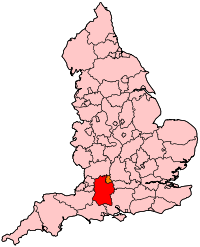
English: Map of Wiltshire within England. |
| Bron | Eie werk |
| Outeur | Wereon |
Lisensiëring
| Ek, die outeursreghouer van hierdie werk, stel dit hiermee in die publieke domein vry. Dit geld wêreldwyd. In sommige lande is dit dalk nie wettiglik moontlik nie. Indien so: Ek verleen aan enigiemand die reg om hierdie werk te gebruik vir enige doel, sonder voorwaardes, tensy sulke voorwaardes deur die wet vereis word. |
Lêergeskiedenis
Klik op die datum/tyd om te sien hoe die lêer destyds gelyk het.
| Datum/Tyd | Duimnael | Dimensies | Gebruiker | Opmerking | |
|---|---|---|---|---|---|
| huidig | 20:50, 22 April 2007 | | 200 × 247 (232 KG) | Wereon | Map of Wiltshire within England. Category:Maps of counties of England |
Lêergebruik
Daar is geen bladsye wat dié lêer gebruik nie.
Globale lêergebruik
Die volgende ander wiki's gebruik hierdie lêer:
- Gebruik in ar.wikipedia.org
- Gebruik in cy.wikipedia.org
- Gebruik in en.wikipedia.org
- Westbury (UK Parliament constituency)
- Salisbury (UK Parliament constituency)
- North Wiltshire (UK Parliament constituency)
- Devizes (UK Parliament constituency)
- North Swindon (UK Parliament constituency)
- South Swindon (UK Parliament constituency)
- Chippenham (UK Parliament constituency)
- South West Wiltshire (UK Parliament constituency)
- 2009 structural changes to local government in England
- Parliamentary constituencies in South West England
- Gebruik in fr.wikipedia.org
- Gebruik in oc.wikipedia.org
- Gebruik in pl.wikipedia.org
- Gebruik in simple.wikipedia.org
- Gebruik in www.wikidata.org
- Gebruik in zh.wikipedia.org