
Lêer:Estonian archipelago (Saaremaa and Hiiumaa).jpg
Geen hoër resolusie is beskikbaar nie.
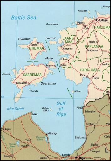
Estonian_archipelago_(Saaremaa_and_Hiiumaa).jpg (354 × 516 piksels, lêergrootte: 33 KG, MIME-tipe: image/jpeg)
Estonian achipelo (Saarema and Hiiumaa) from en:wiki
This image is an edited version of the original image from the Perry-Castañeda Library Map Collection ([1]) at the University of Texas Libraries. Editing and original upload by en:user:Pascal on en:wiki
See http://www.lib.utexas.edu/maps/europe/estonia_pol99.jpg
The Frequently Asked Questions section indicates that unless otherwise indicated, maps are in the public domain. No such indication for this image.

|
This map image could be re-created using vector graphics as an SVG file. This has several advantages; see Commons:Media for cleanup for more information. If an SVG form of this image is available, please upload it and afterwards replace this template with
{{vector version available|new image name}}.
It is recommended to name the SVG file “Estonian archipelago (Saaremaa and Hiiumaa).svg”—then the template Vector version available (or Vva) does not need the new image name parameter. |


| This work has been released into the public domain by its author, Perry-Castañeda Library. This applies worldwide. In sommige lande is dit dalk nie wettiglik moontlik nie. Indien so: Perry-Castañeda Library grants anyone the right to use this work for any purpose, without any conditions, unless such conditions are required by law.
|
_(cropped_230x260).jpg)
.jpg)
Lêergeskiedenis
Klik op die datum/tyd om te sien hoe die lêer destyds gelyk het.
| Datum/Tyd | Duimnael | Dimensies | Gebruiker | Opmerking | |
|---|---|---|---|---|---|
| huidig | 18:55, 18 April 2007 | | 354 × 516 (33 KG) | Tene~commonswiki | Reverted to earlier revision |
| 18:52, 18 April 2007 |  | 354 × 516 (33 KG) | Tene~commonswiki | {{Information |Description=Map Of Estonian archipelago (Saaremaa and Hiiumaa) from http://www.lib.utexas.edu/maps/europe/estonia_pol99.jpg See talk page for copyright explanation. Quote... "Most of the maps scanned by the University of Texas Libraries | |
| 19:05, 20 Maart 2005 |  | 354 × 516 (33 KG) | Laurens~commonswiki | Estonian achipelo (Saarema and Hiiumaa) from en:wiki |
Lêergebruik
Globale lêergebruik
Die volgende ander wiki's gebruik hierdie lêer:
- Gebruik in ar.wikipedia.org
- Gebruik in arz.wikipedia.org
- Gebruik in avk.wikipedia.org
- Gebruik in az.wikipedia.org
- Gebruik in az.wiktionary.org
- Gebruik in be-tarask.wikipedia.org
- Gebruik in bg.wikipedia.org
- Gebruik in bn.wikipedia.org
- Gebruik in br.wikipedia.org
- Gebruik in ca.wikipedia.org
- Gebruik in ceb.wikipedia.org
- Gebruik in cs.wikipedia.org
- Gebruik in cy.wikipedia.org
- Gebruik in da.wikipedia.org
- Gebruik in de.wikipedia.org
- Gebruik in dsb.wikipedia.org
- Gebruik in el.wikipedia.org
- Gebruik in en.wikipedia.org
- Gebruik in en.wikivoyage.org
- Gebruik in eo.wikipedia.org
- Gebruik in es.wikipedia.org
Wys meer globale gebruik van die lêer.
.jpg)
.jpg)