
Lêer:French Guiana CIA.gif
Geen hoër resolusie is beskikbaar nie.
French_Guiana_CIA.gif (329 × 352 piksels, lêergrootte: 11 KG, MIME-tipe: image/gif)
Opsomming
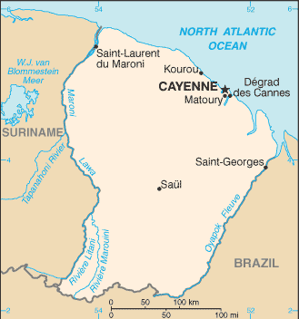
| Beskrywing |
English: Map of French Guiana |
| Bron |
Taken from the CIA World Factbook web site on |
| Outeur |
Lisensiëring
This image is in the public domain because it contains materials that originally came from the United States Central Intelligence Agency's World Factbook.
|
 |
Oorspronklike oplaailogboek
The original description page was here. All following user names refer to en.wikipedia.
- 2006-01-18 08:54 Hoshie 329×352× (11208 bytes) Updated map of French Guiana from CIA website, 10 January 2006
- 2005-12-22 22:31 Eric Shalov 330×355× (8264 bytes) == Summary == Map of [[French Guiana]] taken from the [[CIA]] [http://www.cia.gov/cia/publications/factbook/maps/fg-map.gif World Factbook] web site on [[December 22]], [[2005]].
Lêergeskiedenis
Klik op die datum/tyd om te sien hoe die lêer destyds gelyk het.
| Datum/Tyd | Duimnael | Dimensies | Gebruiker | Opmerking | |
|---|---|---|---|---|---|
| huidig | 18:13, 25 Januarie 2015 | | 329 × 352 (11 KG) | OgreBot | (BOT): Uploading old version of file from en.wikipedia; originally uploaded on 2006-01-18 08:54:32 by Hoshie |
| 23:01, 2 Januarie 2006 |  | 330 × 355 (8 KG) | Walden69 | Map of French Guiana taken from the CIA World Factbook web site on December 22, 2005. [edit] Licensing This image is a map or flag taken and/or modified from the Central Intelligence Agency's World Factbook. Under United States copyright law, all informa |
Lêergebruik
Die volgende bladsy gebruik dié lêer:
Globale lêergebruik
Die volgende ander wiki's gebruik hierdie lêer:
- Gebruik in be-tarask.wikipedia.org
- Gebruik in en.wikipedia.org
- Gebruik in fa.wikipedia.org
- Gebruik in frp.wikipedia.org
- Gebruik in fr.wikipedia.org
- Gebruik in fr.wikinews.org
- Gebruik in gcr.wikipedia.org
- Gebruik in gd.wikipedia.org
- Gebruik in ig.wikipedia.org
- Gebruik in ja.wikipedia.org
- Gebruik in kaa.wikipedia.org
- Gebruik in ka.wikipedia.org
- Gebruik in lb.wikipedia.org
- Gebruik in lt.wikipedia.org
- Gebruik in lt.wiktionary.org
- Gebruik in mr.wikipedia.org
- Gebruik in nl.wikipedia.org
- Gebruik in no.wikipedia.org
- Gebruik in oc.wikipedia.org
- Gebruik in pcd.wikipedia.org
- Gebruik in pt.wikipedia.org
- Gebruik in ro.wikipedia.org
- Gebruik in sat.wikipedia.org
- Gebruik in sm.wikipedia.org
- Gebruik in th.wikipedia.org
- Gebruik in tr.wikipedia.org
- Gebruik in vls.wikipedia.org
- Gebruik in xmf.wikipedia.org
- Gebruik in zh.wikipedia.org