
Lêer:Hong Kong Skyline Restitch - Dec 2007.jpg

Grootte van hierdie voorskou: 800 × 347 piksels. Ander resolusies: 320 × 139 piksels | 640 × 278 piksels | 1 024 × 444 piksels | 1 280 × 555 piksels | 4 250 × 1 844 piksels.
Oorspronklike lêer (4 250 × 1 844 piksels, lêergrootte: 3,93 MG, MIME-tipe: image/jpeg)
Opsomming
| Beskrywing |
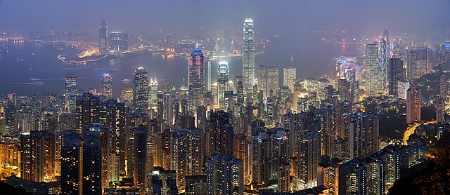
Deutsch: Skyline von Hong Kong betrachtet vom Victoria Peak. Zusammengesetzt aus 78 Aufnahmen (26×3).
English: A 26 segment × 3 exposure (78 frames in total) panoramic view of the Hong Kong skyline taken from a path around Victoria Peak.
Français : Vue panoramique de Hong Kong depuis un sentier de Victoria Peak. Image construite en assemblant 78 clichés (26 visées × 3 expositions) réalisés avecun appareil Canon 5D et un objectif 85mm f/1.8 réglé sur f/5.6. |
| Datum | |
| Bron | Eie werk |
| Outeur | Diliff |
| Toestemming (Hergebruik van die lêer) |
Summary:In using this image or any subsequent derivatives of it, you are required to release the image under the same license. As such, any reproduction of this image, in any medium, must appear with a copy of, or full URL of the license.Attribution of this image to the author (DAVID ILIFF) is also required, preferably in a prominent location near the image.No other conditions may be added to, or removed from this license without the permission of the author and copyright holder.Suggested attribution: "Photo by DAVID ILIFF. License: CC BY-SA 3.0"Please review the full license requirements carefully before using this image. If you would like to clarify the terms of the license or negotiate less restrictive commercial licensing outside of the bounds of GFDL/CC-BY-SA, please contact me by email, or if you don't have a Wikipedia account you can either leave a message on my talk page with your contact details and your request, or you can contact me on Facebook. Please also send a 'friend request' to ensure that I am aware of your message. |
| Ander weergawes |
|

| Kameraligging | | Hierdie en ander beelde in: OpenStreetMap |
|---|
|
Hierdie beeld is gekies as beeld van die dag op 6 Julie 2008. Die beeld het die volgende beskrywing: English: Panoramic view of the Hong Kong skyline taken from a path around Victoria Peak Ander tale:
Bosanski: Panoramski pogled na hongkoški horizont sa staze kod vrha Viktorija. English: Panoramic view of the Hong Kong skyline taken from a path around Victoria Peak Español: Vista panorámica del distrito central de Hong Kong desde la Cumbre Victoria. Français : Vue panoramique de Hong Kong depuis un sentier de Victoria Peak. Image construite en assemblant 78 clichés (26 visées × 3 expositions) réalisés avec un appareil Canon 5D et un objectif 85mm f/1.8 réglé sur f/5.6. Italiano: Vista di Hong Kong dal Victoria Peak, Cina. Magyar: Hongkongi panorámakép a Viktória-csúcsról nézve Nederlands: Panorama van het stedelijk silhouet van Hongkong, gezien vanaf een pad rond Victoria Peak, de hoogste berg van Hongkong Island Português: Vista panorâmica do distrito central de Hong Kong, feita dos arredores do pico Victoria. Suomi: Näkymä Hong Kongin yli läheiseltä Victoria Peak -vuorelta Беларуская: Панарама Ганконга з гары Вікторыя-Пік. Українська: Панорама Гонконгу з гори Вікторія (Victoria Peak) मराठी: हाँग काँग चे परिदृश्य 한국어: 홍콩 빅토리아 피크에서 바라본 야경. العربية : صورة بانورامية للأفق في هونج كونج. |
| Camera Model | Canon EOS 5D |
|---|---|
| Aperture | f/5.6 |
| Lens | 85 mm f/1.8 |
| Focal length | 85 mm |
This image has been assessed using the Quality image guidelines and is considered a Quality image.
|
Lisensiëring
Ek, die outeursreghouer van hierdie werk, publiseer dit onder die volgende lisensie:

|
Toestemming word verleen tot die kopiëring, verspreiding en/of wysiging van hierdie dokument onder die voorwaardes van die GNU-lisensie vir vrye dokumentasie, weergawe 1.2 of enige latere weergawe uitgegee deur die Stigting vir Vrye Sagteware, sonder Invariante Dele, geen Voorbladtekste en geen Agterbladtekste. 'n Kopie van hierdie lisensie is ingesluit in die afdeling getiteld GNU Free Documentation License. |
This file is licensed under the Creative Commons Attribution 3.0 Unported license.
- U is vry:
- om te deel – die werk kopieer, versprei en deurgee
- om te hermeng – om die werk aan te pas
- Onder die volgende voorwaardes:
- naamsvermelding – U moet die nodige krediet gee, 'n skakel na die lisensie verskaf en aandui of daar veranderinge aangebring is. U mag dit op enige redelike manier doen, maar nie op enige manier wat daarop dui dat die lisensiegewer u of u gebruik onderskryf nie.
U kan die lisensie van u keuse kies.
Lêergeskiedenis
Klik op die datum/tyd om te sien hoe die lêer destyds gelyk het.
| Datum/Tyd | Duimnael | Dimensies | Gebruiker | Opmerking | |
|---|---|---|---|---|---|
| huidig | 21:55, 29 April 2008 | | 4 250 × 1 844 (3,93 MG) | Diliff | == Summary == {{Information |Description={{en|A 26 segment x 3 exposure (78 frames in total) panoramic view of the Hong Kong skyline taken from a path around Victoria Peak. Taken by myself with a Canon 5D and 85mm f/1.8 lens at f/5.6.}} {{de|Skyline von H |
Lêergebruik
Die volgende 3 bladsye gebruik dié lêer:
Globale lêergebruik
Die volgende ander wiki's gebruik hierdie lêer:
- Gebruik in ace.wikipedia.org
- Gebruik in arc.wikipedia.org
- Gebruik in ar.wikipedia.org
- Gebruik in arz.wikipedia.org
- Gebruik in as.wikipedia.org
- Gebruik in azb.wikipedia.org
- Gebruik in bn.wikipedia.org
- Gebruik in bxr.wikipedia.org
- Gebruik in ca.wikipedia.org
- Gebruik in ceb.wikipedia.org
- Gebruik in crh.wikipedia.org
- Gebruik in cs.wikipedia.org
- Gebruik in cv.wikipedia.org
- Gebruik in da.wikipedia.org
- Gebruik in de.wikipedia.org
- Gebruik in diq.wikipedia.org
- Gebruik in dv.wikipedia.org
- Gebruik in el.wikipedia.org
- Gebruik in en.wikipedia.org
- User:Diliff
- Portal:Politics/Featured content
- Wikipedia:WikiProject Urban studies and planning
- Portal:China/Selected article and pictures
- Wikipedia:WikiProject Countries/Assessment
- Portal:Capitalism/Selected article
- Portal:Capitalism/Selected article/1
- Wikipedia:Featured pictures/Places/Panorama
- Wikipedia:WikiProject China/Featured and good content
- Portal:China/Selected picture
- Portal:Architecture/Townscape images
- Wikipedia:Featured pictures thumbs/11
- Wikipedia:Featured picture candidates/Hong Kong Skyline Restitch - Dec 2007.jpg
- Wikipedia:Featured picture candidates/May-2008
Wys meer globale gebruik van die lêer.