
Lêer:LocationSouthAfrica-1990.png
Geen hoër resolusie is beskikbaar nie.
LocationSouthAfrica-1990.png (250 × 115 piksels, lêergrootte: 5 KG, MIME-tipe: image/png)

|
File:South Africa in its region (1990).svg is a vector version of this file. It should be used in place of this PNG file when not inferior.
File:LocationSouthAfrica-1990.png → File:South Africa in its region (1990).svg
For more information, see Help:SVG. |
.svg) |
Opsomming
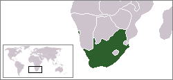
A locator map of South Africa showing en:Walvis Bay. This locator map is intended for South African articles taking place before the transfer of Walvis Bay to Namibia in 1994. The orginal map is by Vardion. Since that map is PD, this one is well.
Lisensiëring
| This work has been released into the public domain by its author, Hoshie. This applies worldwide. In sommige lande is dit dalk nie wettiglik moontlik nie. Indien so: |
Lêergeskiedenis
Klik op die datum/tyd om te sien hoe die lêer destyds gelyk het.
| Datum/Tyd | Duimnaelskets | Dimensies | Gebruiker | Opmerking | |
|---|---|---|---|---|---|
| huidig | 07:26, 17 Desember 2009 | | 250 × 115 (5 KG) | Hoshie | Reverted to version as of 03:34, 16 August 2006 rv, Nambia itself wasn't a part of S. Africa |
| 18:37, 2 Desember 2008 |  | 250 × 115 (5 KG) | ChrisDHDR | South Africa included Namibia at the time | |
| 03:34, 16 Augustus 2006 |  | 250 × 115 (5 KG) | Hoshie | == Summary == A locator map of South Africa showing en:Walvis Bay. This locator map is intended for South African articles taking place before the transfer of Walvis Bay to Nambia in 1994. The orginal map is by [[Us |
Lêergebruik
Daar is geen bladsye wat dié lêer gebruik nie.