
Lêer:Romani population average estimate.png
Romani_population_average_estimate.png (788 × 596 piksels, lêergrootte: 160 KG, MIME-tipe: image/png)

|
This map image could be re-created using vector graphics as an SVG file. This has several advantages; see Commons:Media for cleanup for more information. If an SVG form of this image is available, please upload it and afterwards replace this template with
{{vector version available|new image name}}.
It is recommended to name the SVG file “Romani population average estimate.svg”—then the template Vector version available (or Vva) does not need the new image name parameter. |
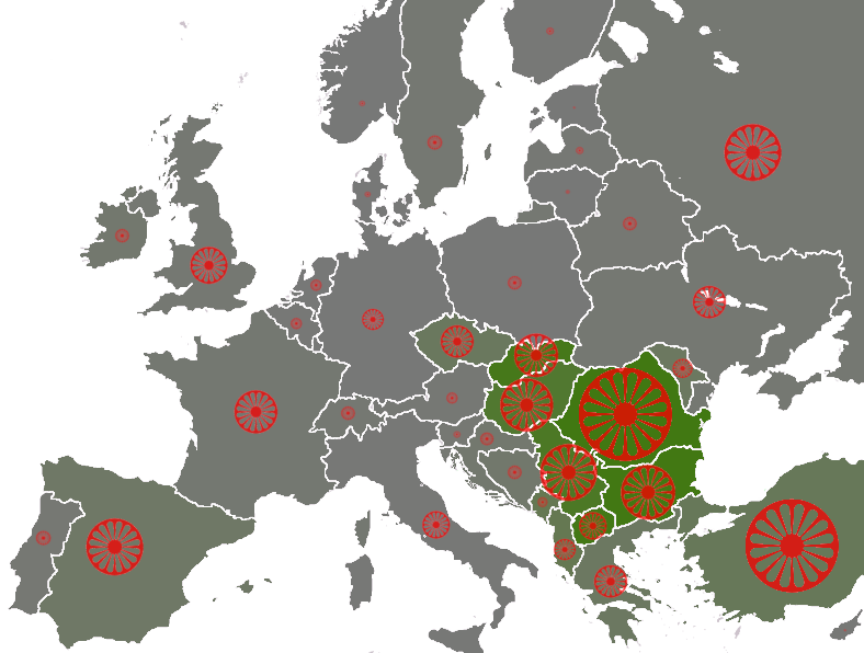
Opsomming
| Beskrywing |
populations of the țigani people by country, showing the "average estimate" published by the Council of Europe[1] (Archived from the original). Based on these estimates are the number of seats by country in the European Roma and Travellers Forum (ERTF) based in Strasbourg. The size of the wheel symbol represents total population by country (Romania 1.85 million), the shade of each country's background colour represents the percentage of Romani with respect to the total population (Romania 8.5%). 0%
5%
10% |
| Datum | (UTC) |
| Bron | |
| Outeur |
|
| Ander weergawes | File:Roma in Europe 2007 cropped.png |
Lisensiëring

|
Toestemming word verleen tot die kopiëring, verspreiding en/of wysiging van hierdie dokument onder die voorwaardes van die GNU-lisensie vir vrye dokumentasie, weergawe 1.2 of enige latere weergawe uitgegee deur die Stigting vir Vrye Sagteware, sonder Invariante Dele, geen Voorbladtekste en geen Agterbladtekste. 'n Kopie van hierdie lisensie is ingesluit in die afdeling getiteld GNU Free Documentation License. |
| Hierdie lêer is gelisensieer onder die Creative Commons Erkenning-Insgelyks Deel 3.0 Onoorgedraagde lisensie. | ||
| Naamsvermelding: Dbachmann | ||
| ||
| This licensing tag was added to this file as part of the GFDL licensing update. |
Oorspronklike oplaailogboek
This image is a derivative work of the following images:
- File:Europe_blank_map.png licensed with PD-user
- 2008-08-04T13:35:42Z Avala 1360x1245 (86403 Bytes) http://news.xinhuanet.com/english/2008-02/19/content_7629464.htm
- 2008-08-01T02:34:17Z Wikibob 1360x1245 (86480 Bytes) Reverted to version as of 16:34, 13 March 2008
- 2008-07-31T14:52:04Z Avala 1360x1245 (86403 Bytes)
- 2008-03-22T21:58:51Z Nightstallion 1360x1245 (86480 Bytes) Reverted to version as of 16:34, 13 March 2008
- 2008-03-19T19:36:05Z Patstuart 1360x1245 (86403 Bytes) Reverted to version as of 18:15, 11 March 2008 - see [[Image talk:BlankMap-World-v6.png#As stated in reversion]]
- 2008-03-13T16:34:01Z Nightstallion 1360x1245 (86480 Bytes) upload a variant if you wish, but the majority in Europe recognises or will recognise.
- 2008-03-11T18:15:58Z Avala 1360x1245 (86403 Bytes) there is no consensus in Europe
- 2008-02-24T14:02:27Z Hoshie 1360x1245 (86480 Bytes) Added Kosovo since it has been internationally recognized
- 2006-06-10T00:20:20Z QuartierLatin1968 1360x1245 (86403 Bytes) Montenegro is now independent; widespread recognition can be expected within the next few weeks
- 2005-08-31T22:16:23Z Gugganij 1360x1245 (47472 Bytes) and again some changes
- 2005-08-31T22:09:44Z Gugganij 1360x1245 (49669 Bytes) some minor changes
- 2005-03-26T19:56:55Z Wiki-vr 1245x1245 (54567 Bytes) Blank map of Europe - use to show countries' locations, EU members, etc. – see examples: *http://commons.wikimedia.org/wiki/Image:EU_Members_Candidates_2004_2007.png *http://commons.wikimedia.org/wiki/Image:Europe_location
Uploaded with derivativeFX
Lêergeskiedenis
Klik op die datum/tyd om te sien hoe die lêer destyds gelyk het.
| Datum/Tyd | Duimnael | Dimensies | Gebruiker | Opmerking | |
|---|---|---|---|---|---|
| huidig | 14:30, 22 Januarie 2009 | | 788 × 596 (160 KG) | Dbachmann | {{Information |Description=populations of the Romani people by country, showing the "average estimate" published by the Council of Europe[http://www.coe.int/t/dg3/romatravellers/Documentation/strategies/statistiques_en.asp#P11_143]. Based on these estimat |
Lêergebruik
Die volgende bladsy gebruik dié lêer:
Globale lêergebruik
Die volgende ander wiki's gebruik hierdie lêer:
- Gebruik in ast.wikipedia.org
- Gebruik in azb.wikipedia.org
- Gebruik in ca.wikipedia.org
- Gebruik in cs.wikipedia.org
- Gebruik in da.wikipedia.org
- Gebruik in en.wikipedia.org
- Gebruik in en.wikinews.org
- Gebruik in eo.wikipedia.org
- Gebruik in es.wikipedia.org
- Gebruik in fr.wikipedia.org
- Gebruik in ga.wikipedia.org
- Gebruik in hi.wikipedia.org
- Gebruik in hu.wikipedia.org
- Gebruik in it.wikipedia.org
- Gebruik in la.wikipedia.org
- Gebruik in lt.wikipedia.org
- Gebruik in lv.wikipedia.org
- Gebruik in pt.wikipedia.org
- Gebruik in sr.wikipedia.org
- Gebruik in wa.wikipedia.org