
Lêer:Swan River.jpg

Grootte van hierdie voorskou: 563 × 599 piksels. Ander resolusies: 225 × 240 piksels | 451 × 480 piksels | 857 × 912 piksels.
Oorspronklike lêer (857 × 912 piksels, lêergrootte: 177 KG, MIME-tipe: image/jpeg)
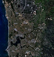
| Beskrywing | This is a map of the Swan River, Western Australia, made with World Wind using Landsat 7 data. | |||
| Bron | NASA | |||
| Outeur | Created by the uploader. Any IP involved in the creation of this image is released into the public domain. | |||
| Toestemming (Hergebruik van die lêer) |
|

Lêergeskiedenis
Klik op die datum/tyd om te sien hoe die lêer destyds gelyk het.
| Datum/Tyd | Duimnael | Dimensies | Gebruiker | Opmerking | |
|---|---|---|---|---|---|
| huidig | 02:56, 16 November 2006 | | 857 × 912 (177 KG) | Hesperian | {{Information |Description=This is a map of the Swan River, Western Australia, made with World Wind using Landsat 7 data. |Source= |Date= |Author=Created by the uploader. Any IP involved in the creation of this image is released into the public domain. |P |
Lêergebruik
Die volgende bladsy gebruik dié lêer:
Globale lêergebruik
Die volgende ander wiki's gebruik hierdie lêer:
- Gebruik in ar.wikipedia.org
- Gebruik in no.wikipedia.org
- Gebruik in pl.wikipedia.org
- Gebruik in ta.wikipedia.org