
Lêer:World map Strabo.jpg

Grootte van hierdie voorskou: 800 × 437 piksels. Ander resolusies: 320 × 175 piksels | 640 × 350 piksels | 1 024 × 559 piksels | 1 280 × 699 piksels | 3 014 × 1 646 piksels.
Oorspronklike lêer (3 014 × 1 646 piksels, lêergrootte: 1,49 MG, MIME-tipe: image/jpeg)
Opsomming
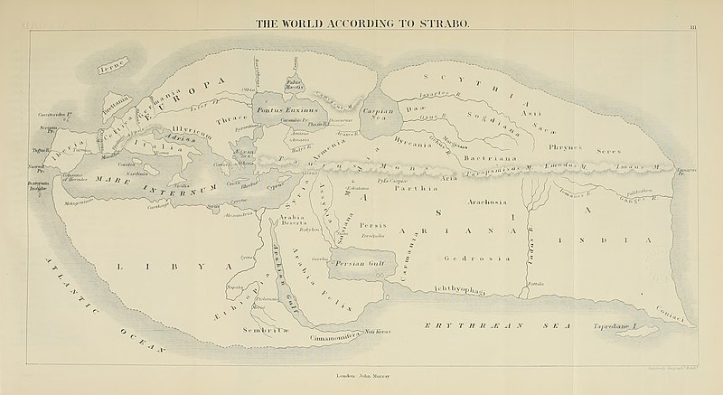
| Beskrywing | 19th century reconstruction of World map according to Strabo (18 A.D.). | ||||||||||||||||||||||||||||||||||||||||||
| Datum | |||||||||||||||||||||||||||||||||||||||||||
| Bron | https://archive.org/download/historyofancient02bunb/historyofancient02bunb_orig_jp2.tar/historyofancient02bunb_orig_jp2%2Fhistoryofancient02bunb_orig_0271.jp2 | ||||||||||||||||||||||||||||||||||||||||||
| Outeur |
|
||||||||||||||||||||||||||||||||||||||||||
| Toestemming (Hergebruik van die lêer) |
Public domain | ||||||||||||||||||||||||||||||||||||||||||
| Ander weergawes |
|
||||||||||||||||||||||||||||||||||||||||||


Lisensiëring
|
This work is in the public domain in its country of origin and other countries and areas where the copyright term is the author's life plus 100 years or fewer. This work is in the public domain in the United States because it was published (or registered with the U.S. Copyright Office) before January 1, 1929. | |
| Hierdie lêer is geïdentifiseer as vry van bekende beperkings onder kopiereg, insluitend alle verwante en naburige regte. | |
Lêergeskiedenis
Klik op die datum/tyd om te sien hoe die lêer destyds gelyk het.
| Datum/Tyd | Duimnael | Dimensies | Gebruiker | Opmerking | |
|---|---|---|---|---|---|
| huidig | 15:03, 5 Julie 2020 | | 3 014 × 1 646 (1,49 MG) | Sette-quattro | higher quality image from https://archive.org/download/historyofancient02bunb/historyofancient02bunb_orig_jp2.tar/historyofancient02bunb_orig_jp2%2Fhistoryofancient02bunb_orig_0271.jp2 |
| 21:11, 29 Februarie 2008 |  | 738 × 458 (65 KG) | Anrie | {{Information |Description=19th century reconstruction of World map according to Strabo (18 A.D.). |Source= [http://www.istrianet.org/istria/history/0000-0999AD/strabo/strabo-cartography.htm istrianet.org |Date=1800s (no exact date give) |Author= No autho |
Lêergebruik
Die volgende bladsy gebruik dié lêer:
Globale lêergebruik
Die volgende ander wiki's gebruik hierdie lêer:
- Gebruik in ca.wikipedia.org
- Gebruik in fy.wikipedia.org
- Gebruik in kk.wikipedia.org
- Gebruik in pl.wikipedia.org