
Lêer:Cayman Islands districts.png

Grootte van hierdie voorskou: 800 × 501 piksels. Ander resolusies: 320 × 201 piksels | 640 × 401 piksels | 975 × 611 piksels.
Oorspronklike lêer (975 × 611 piksels, lêergrootte: 2 KG, MIME-tipe: image/png)
Opsomming
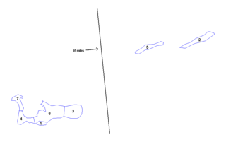
| Beskrywing | Map of the districts of the Cayman Islands. Created by Rarelibra 18:20, 31 March 2006 (UTC) for public domain use. Created using MapInfo Professional v7.5 and various mapping resources. |
| Datum | 25 November 2006 (original upload date) |
| Bron | Geen machineleesbare bron opgegeven. Eigen werk aangenomen (gebaseerd op auteursrechtclaims). |
| Outeur | Geen machineleesbare auteur aanwezig. Op basis van auteursrechtclaims wordt auteur Electionworld aangenomen. |
Lisensiëring
| Ek, die outeursreghouer van hierdie werk, stel dit hiermee in die publieke domein vry. Dit geld wêreldwyd. In sommige lande is dit dalk nie wettiglik moontlik nie. Indien so: Ek verleen aan enigiemand die reg om hierdie werk te gebruik vir enige doel, sonder voorwaardes, tensy sulke voorwaardes deur die wet vereis word. |
Lêergeskiedenis
Klik op die datum/tyd om te sien hoe die lêer destyds gelyk het.
| Datum/Tyd | Duimnael | Dimensies | Gebruiker | Opmerking | |
|---|---|---|---|---|---|
| huidig | 21:19, 22 Maart 2015 | | 975 × 611 (2 KG) | Ras67 | cropped, -bg, -opt. |
| 22:04, 25 November 2006 |  | 1 025 × 624 (7 KG) | Electionworld | == Summary == Map of the districts of the Cayman Islands. Created by Rarelibra 18:20, 31 March 2006 (UTC) for public domain use. Created using MapInfo Professional v7.5 and various mapping resources. == Licensing == {{PD-self}} [[Catego |
Lêergebruik
Die volgende bladsy gebruik dié lêer:
Globale lêergebruik
Die volgende ander wiki's gebruik hierdie lêer:
- Gebruik in en.wikipedia.org
- Gebruik in eu.wikipedia.org
- Gebruik in frr.wikipedia.org
- Gebruik in hu.wikipedia.org
- Gebruik in ja.wikipedia.org
- Gebruik in tr.wikipedia.org