
Lêer:Adelaide metropolitan area map.svg

Size of this PNG preview of this SVG file: 246 × 599 piksels. Ander resolusies: 98 × 240 piksels | 197 × 480 piksels | 315 × 768 piksels | 420 × 1 024 piksels | 840 × 2 048 piksels | 974 × 2 373 piksels.
Oorspronklike lêer (SVG-lêer, normaalweg 974 × 2 373 piksels, lêergrootte: 298 KG)
Opsomming
| Beskrywing |
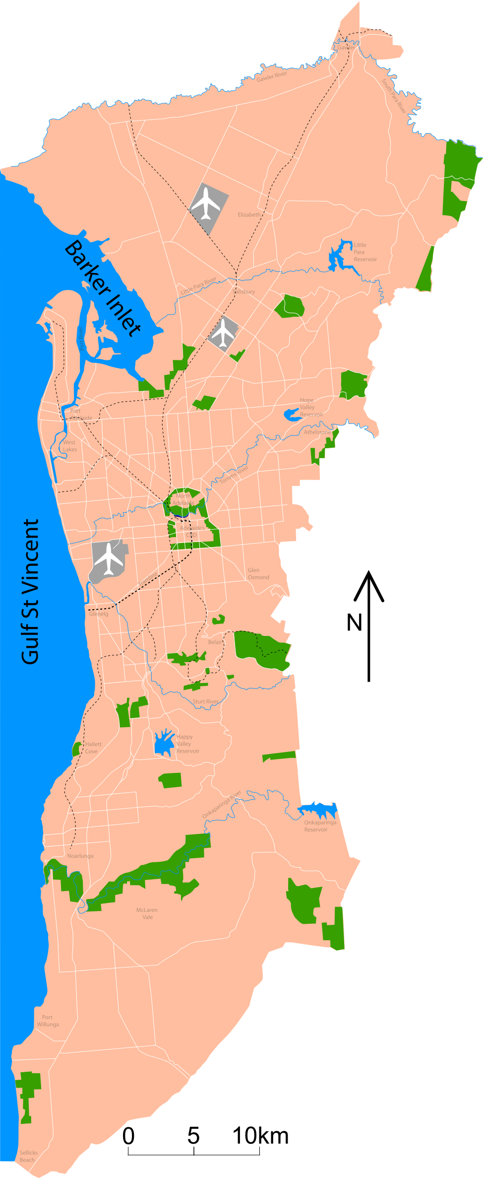
Map of Adelaide Shows major roads (per gregory's 2004 street directory), airports (adelaide, parafield and edinburgh airforce base) and all public reserves or parks > about 130 acres. Council district maps dated from 2004->2007 used to determine the landward boundary |
| Datum | |
| Bron | Eie werk |
| Outeur | Peripitus |
| SVG genesis | This map was created with Adobe Illustrator. |
Lisensiëring
Ek, die outeursreghouer van hierdie werk, publiseer dit onder die volgende lisensie:

|
Toestemming word verleen tot die kopiëring, verspreiding en/of wysiging van hierdie dokument onder die voorwaardes van die GNU-lisensie vir vrye dokumentasie, weergawe 1.2 of enige latere weergawe uitgegee deur die Stigting vir Vrye Sagteware, sonder Invariante Dele, geen Voorbladtekste en geen Agterbladtekste. 'n Kopie van hierdie lisensie is ingesluit in die afdeling getiteld GNU Free Documentation License. |
This file is licensed under the Creative Commons Attribution-Share Alike 3.0 Unported, 2.5 Generic, 2.0 Generic and 1.0 Generic license.
- U is vry:
- om te deel – die werk kopieer, versprei en deurgee
- om te hermeng – om die werk aan te pas
- Onder die volgende voorwaardes:
- naamsvermelding – U moet die nodige krediet gee, 'n skakel na die lisensie verskaf en aandui of daar veranderinge aangebring is. U mag dit op enige redelike manier doen, maar nie op enige manier wat daarop dui dat die lisensiegewer u of u gebruik onderskryf nie.
- insgelyks – As u die materiaal hermix, transformeer of voortbou, moet u u bydraes versprei onder die dieselfde of versoenbare lisensie as die oorspronklike.
U kan die lisensie van u keuse kies.
Lêergeskiedenis
Klik op die datum/tyd om te sien hoe die lêer destyds gelyk het.
| Datum/Tyd | Duimnael | Dimensies | Gebruiker | Opmerking | |
|---|---|---|---|---|---|
| huidig | 10:53, 26 Januarie 2015 | 974 × 2 373 (298 KG) | Wereldburger758 | Valid SVG now. | |
| 02:45, 3 November 2007 | 974 × 2 373 (331 KG) | Peripitus | {{Information |Description=Map of Adelaide Shows major roads (per gregory's 2004 street directory), airports (adelaide, parafield and edinburgh airforce base) and all public reserves or parks > about 130 acres. Council district maps dated from 2004->2007 | ||
| 09:13, 24 Oktober 2007 | 974 × 2 373 (136 KG) | Peripitus | {{Information |Description=Map of Adelaide Shows major roads (per gregory's 2004 street directory), airports (adelaide, parafield and edinburgh airforce base) and all public reserves or parks > about 130 acres. Council district maps dated from 2004->2007 | ||
| 21:32, 23 Oktober 2007 | 487 × 1 188 (144 KG) | Peripitus | {{Information |Description=Map of Adelaide Shows major roads (per gregory's 2004 street directory), airports (adelaide, parafield and edinburgh airforce base) and all public reserves or parks > about 130 acres. Council district maps dated from 2004->2007 | ||
| 13:38, 23 Oktober 2007 | 487 × 1 188 (145 KG) | Peripitus | {{Information |Description=Map of Adelaide Shows major roads (per gregory's 2004 street directory), airports (adelaide, parafield and edinburgh airforce base) and all public reserves or parks > about 130 acres. Council district maps dated from 2004->2007 | ||
| 13:35, 23 Oktober 2007 |  | 749 × 1 188 (145 KG) | Peripitus | Reverted to version as of 13:26, 23 October 2007 | |
| 13:34, 23 Oktober 2007 | 487 × 1 188 (166 KG) | Peripitus | {{Information |Description=Map of Adelaide Shows major roads (per gregory's 2004 street directory), airports (adelaide, parafield and edinburgh airforce base) and all public reserves or parks > about 130 acres. Council district maps dated from 2004->2007 | ||
| 13:26, 23 Oktober 2007 |  | 749 × 1 188 (145 KG) | Peripitus | {{Information |Description=Map of Adelaide Shows major roads (per gregory's 2004 street directory), airports (adelaide, parafield and edinburgh airforce base) and all public reserves or parks > about 130 acres. Council district maps dated from 2004->2007 |
Lêergebruik
Die volgende bladsy gebruik dié lêer:
Globale lêergebruik
Die volgende ander wiki's gebruik hierdie lêer:
- Gebruik in ckb.wikipedia.org
- Gebruik in el.wikipedia.org
- Gebruik in en.wikipedia.org
- Gebruik in es.wikipedia.org
- Gebruik in hr.wikipedia.org
- Gebruik in ka.wikipedia.org
- Gebruik in ms.wikipedia.org
- Gebruik in ru.wikipedia.org