
Lêer:Alice Springs ridge.jpeg
Geen hoër resolusie is beskikbaar nie.
Alice_Springs_ridge.jpeg (768 × 511 piksels, lêergrootte: 436 KG, MIME-tipe: image/jpeg)
Opsomming
| Kameraligging | | Hierdie en ander beelde in: OpenStreetMap |
|---|
Lisensiëring
Codrington, Stephen. Planet Geography 3rd Edition (2005) [1]
Personal photo by Stephen Codrington uploaded with permission for the benefit of geography on Wikimedia projects. This and other photos by Stephen Codrington are available to download and order at his personal website.
This file is licensed under the Creative Commons Attribution 2.5 Generic license.
Naamsvermelding: Stephen Codrington
- U is vry:
- om te deel – die werk kopieer, versprei en deurgee
- om te hermeng – om die werk aan te pas
- Onder die volgende voorwaardes:
- naamsvermelding – U moet die nodige krediet gee, 'n skakel na die lisensie verskaf en aandui of daar veranderinge aangebring is. U mag dit op enige redelike manier doen, maar nie op enige manier wat daarop dui dat die lisensiegewer u of u gebruik onderskryf nie.
Lêergeskiedenis
Klik op die datum/tyd om te sien hoe die lêer destyds gelyk het.
| Datum/Tyd | Duimnael | Dimensies | Gebruiker | Opmerking | |
|---|---|---|---|---|---|
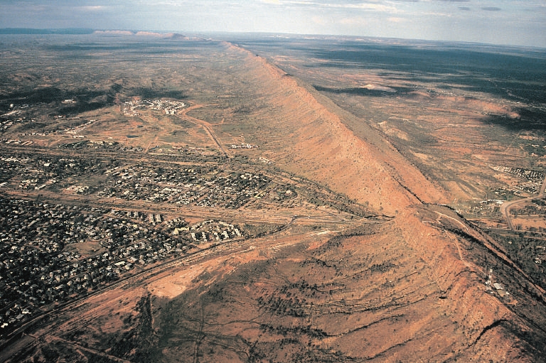
| huidig | 02:57, 12 Julie 2005 | | 768 × 511 (436 KG) | Komencanto~commonswiki | Caption: "''Figure 3.14 One of the larger settlements on the road that crosses Australia from north to south is Alice Springs. This view shows the transport links passing through a convenient gap in the ridge beside which the town has been built. The host |
Lêergebruik
Die volgende bladsy gebruik dié lêer:
Globale lêergebruik
Die volgende ander wiki's gebruik hierdie lêer:
- Gebruik in arz.wikipedia.org
- Gebruik in bg.wikipedia.org
- Gebruik in de.wikipedia.org
- Gebruik in de.wikivoyage.org
- Gebruik in en.wikipedia.org
- Gebruik in es.wikipedia.org
- Gebruik in fr.wikipedia.org
- Gebruik in fr.wikivoyage.org
- Gebruik in hu.wikipedia.org
- Gebruik in it.wikipedia.org
- Gebruik in ja.wikipedia.org
- Gebruik in ky.wikipedia.org
- Gebruik in ml.wikipedia.org
- Gebruik in nl.wikipedia.org
- Gebruik in nn.wikipedia.org
- Gebruik in ru.wikipedia.org
- Gebruik in simple.wikipedia.org
- Gebruik in tr.wikipedia.org
- Gebruik in uk.wikipedia.org
- Gebruik in vi.wikipedia.org
- Gebruik in www.wikidata.org