
Lêer:Antarctic Peninsula satellite image.jpg

Grootte van hierdie voorskou: 490 × 599 piksels. Ander resolusies: 196 × 240 piksels | 392 × 480 piksels | 628 × 768 piksels | 837 × 1 024 piksels | 1 509 × 1 846 piksels.
Oorspronklike lêer (1 509 × 1 846 piksels, lêergrootte: 706 KG, MIME-tipe: image/jpeg)
Opsomming
| Beskrywing |
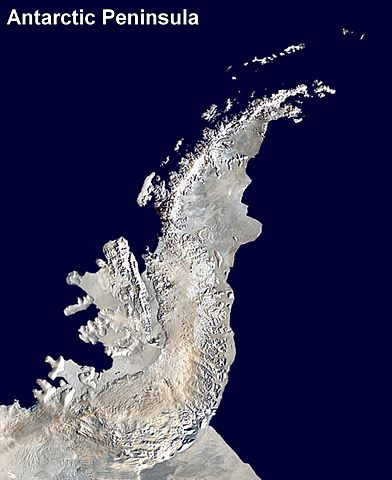
English: Antarctic Peninsula satellite image. An orthographic projection of NASA's Blue Marble data set (1 km resolution global satellite composite). "MODIS observations of polar sea ice were combined with observations of Antarctica made by the National Oceanic and Atmospheric Administration’s AVHRR sensor—the Advanced Very High Resolution Radiometer." Image was generated using a custom C program for handling the Blue Marble files, with orthographic projection formulas from MathWorld.
The black pixels are presumed to be due to missing data in the land/sea mask used in making the original Blue Marble image.
|
||
| Datum | (UTC) | ||
| Bron | |||
| Outeur |
|
Lisensiëring
| This work has been released into the public domain by its author, Anna Frodesiak. This applies worldwide. In sommige lande is dit dalk nie wettiglik moontlik nie. Indien so: |
Oorspronklike oplaailogboek
This image is a derivative work of the following images:
- File:Antarctica_6400px_from_Blue_Marble.jpg licensed with PD-user
- 2006-10-05T14:21:53Z Davepape 6400x6400 (3472802 Bytes) touched up part with missing data
- 2006-10-05T07:49:09Z Davepape 6400x6400 (3472752 Bytes) {{Information |Description=[[w:Antarctica|Antarctica]]. An orthographic projection of NASA's Blue Marble data set (1 km resolution global satellite composite). "MODIS observations of polar sea ice were combined with observa
Uploaded with derivativeFX
Lêergeskiedenis
Klik op die datum/tyd om te sien hoe die lêer destyds gelyk het.
| Datum/Tyd | Duimnael | Dimensies | Gebruiker | Opmerking | |
|---|---|---|---|---|---|
| huidig | 23:08, 5 April 2009 | | 1 509 × 1 846 (706 KG) | Anna Frodesiak | {{Information |Description=Antarctic Peninsula satellite image. An orthographic projection of NASA's Blue Marble data set (1 km resolution global satellite composite). "MODIS observations of polar sea ice were combined with observations of Antarctica made |
Lêergebruik
Die volgende bladsy gebruik dié lêer:
Globale lêergebruik
Die volgende ander wiki's gebruik hierdie lêer:
- Gebruik in ast.wikipedia.org
- Gebruik in bs.wikipedia.org
- Gebruik in ca.wikipedia.org
- Gebruik in da.wikipedia.org
- Gebruik in en.wikipedia.org
- Antarctic Peninsula
- Mount Jackson (Antarctica)
- Breaker Island
- Dream Island
- Christine Island
- Cormorant Island
- Eichorst Island
- Shortcut Island
- Biscoe Point
- Halfway Island (Palmer Archipelago)
- Gerlache Strait
- Hermit Island (Antarctic)
- Humble Island
- Janus Island
- Laggard Island
- Limitrophe Island
- Lipps Island
- Ohlin Island
- Outcast Islands
- Torgersen Island
- Spume Island
- Stepping Stones (islands)
- Surge Rocks
- Galindez Island
- Quintana Island
- Cobalescou Island
- Doumer Island
- Bremen Island
- Neumayer Channel
- Smooth Island (Antarctica)
- Wilhelm Archipelago
- Betbeder Islands
- Meek Channel
- Shelter Islands
- Sigma Islands
- Yalour Islands
- Yoke Island
- Tripod Island
- Zigzag Island
- Spert Island
- Indicator Island
- Intercurrence Island
- Irizar Island
Wys meer globale gebruik van die lêer.