
Lêer:Australia first map.jpg

Oorspronklike lêer (3 604 × 2 696 piksels, lêergrootte: 3,81 MG, MIME-tipe: image/jpeg)
Opsomming
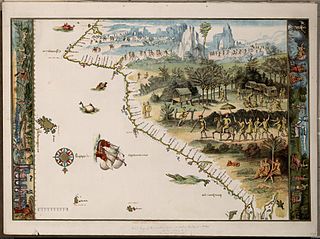
Facsimile of chart from Nicholas Vallard's manuscript sea atlas (1547), showing Jave La Grande's west coast. The facsimile was given the title "The first Map of Australia from Nicholas Vallard's Atlas, 1547" by the English publisher in 1856. The original Vallard chart was produced in Dieppe, France in the 16th century. It is thought by several writers to represent Portuguese charting of the western coast of Australia, however the geographical features (i.e. 'cap' cape, 'Illa' Island, 'illet' islet, 'port' harbour) are actually written in Catalan. This copy is held by the National Library of Australia. [cartographic material] : from the Library of Sir Thomas Phillipps, Bart. at Middle Hill, 1856. Image from the National Library of Australia: http://nla.gov.au/nla.map-rm2393 The original Vallard map is held by the Huntington Library, San Marino, California and can be viewed at http://sunsite3.berkeley.edu/hehweb/HM29.html archive copy at the Wayback Machine
From NLA catalogure information: Scale: Scale indeterminable. Publisher: [Worcestershire : Middle Hill Press, 1856] (Chester : McGahey chromo. lith.) Date: 1856 Material Type: Map Physical Description: 1 map : col. ; 37.6 x 55.4 cm. Notes: Facsimile of chart from Nicholas Vallard's manuscript sea atlas (1547), now held in the Huntington Library, San Marino, California.
Map is in folder with title: Vallard's map of the coast of Greater Java.
Lisensiëring
|
This work is in the public domain in its country of origin and other countries and areas where the copyright term is the author's life plus 70 years or fewer.
| |
| Hierdie lêer is geïdentifiseer as vry van bekende beperkings onder kopiereg, insluitend alle verwante en naburige regte. | |
Lêergeskiedenis
Klik op die datum/tyd om te sien hoe die lêer destyds gelyk het.
| Datum/Tyd | Duimnael | Dimensies | Gebruiker | Opmerking | |
|---|---|---|---|---|---|
| huidig | 00:58, 17 Oktober 2006 | | 3 604 × 2 696 (3,81 MG) | Gobeirne | |
| 22:55, 30 November 2005 |  | 760 × 580 (110 KG) | Matilda | First map of Australia [cartographic material] : from Nicholas Vallard's atlas, 1547, in the Library of Sir Thomas Phillipps, Bart. at Middle Hill, 1856. Image from the National Library of Australia: http://nla.gov.au/nla.map-rm2393 From NLA catalogure i |
Lêergebruik
Die volgende bladsy gebruik dié lêer:
Globale lêergebruik
Die volgende ander wiki's gebruik hierdie lêer:
- Gebruik in en.wikipedia.org
- Gebruik in es.wikipedia.org
- Gebruik in fr.wikipedia.org
- Gebruik in he.wikipedia.org
- Gebruik in id.wikipedia.org
- Gebruik in it.wikipedia.org
- Gebruik in ja.wikipedia.org
- Gebruik in jv.wikipedia.org
- Gebruik in ka.wikipedia.org
- Gebruik in mk.wikipedia.org
- Gebruik in nl.wikipedia.org
- Gebruik in pt.wikipedia.org
- Descoberta da Austrália
- Predefinição:Esboço-históriaau
- Mapas de Dieppe
- Colônia de Nova Gales do Sul
- Ordem da Austrália
- Teoria da descoberta da Austrália pelos portugueses
- Eureka Stockade
- Federação da Austrália
- Austrália Branca
- Colônia da Tasmânia
- Colônia de Queensland
- Federalismo na Austrália
- João Alfonso
- Gebruik in ru.wikipedia.org
- Gebruik in ru.wikiversity.org
- Gebruik in sr.wikipedia.org
- Gebruik in tr.wikipedia.org
Wys meer globale gebruik van die lêer.