
Lêer:Brooklyn, Vol. 3, Double Page Plate No. 39; Sub Plan from Plate 38; (Map bounded by Barren Island, Part of Ruffle Bar; Including Duck Point Marshes, Pumpkin Patch Meadows) NYPL1703808.tiff

Size of this JPG preview of this TIF file: 800 × 594 piksels. Ander resolusies: 320 × 237 piksels | 640 × 475 piksels | 1 024 × 760 piksels | 1 280 × 950 piksels | 2 560 × 1 899 piksels | 6 712 × 4 980 piksels.
Oorspronklike lêer (6 712 × 4 980 piksels, lêergrootte: 95,63 MG, MIME-tipe: image/tiff)
Opsomming
| Beskrywing | Brooklyn, Vol. 3, Double Page Plate No. 39; Sub Plan from Plate 38; [Map bounded by Barren Island, Part of Ruffle Bar; Including Duck Point Marshes, Pumpkin Patch Meadows]; Atlases of New York city. / Atlas of the borough of Brooklyn, city of New York. Newly constructed and based upon official maps and plans on file in the Municipal Building and Registers Office (Hall of Records). Supplemented by careful field measurements and observations / by and under the direction of Hugo Ullitz. / Volume 3 | |||||||||||||||||||||||
| Catalogue call number | Map Div.+++ (Brooklyn, New York) (Hyde, E.B., Map Co., Inc. Atlas of the borough of Brooklyn, city of New York. 1916) | |||||||||||||||||||||||
| Item/Page/Plate | 39 | |||||||||||||||||||||||
| Datum | ||||||||||||||||||||||||
| Bron |
http://digitalgallery.nypl.org/nypldigital/dgkeysearchdetail.cfm?imageID=1703808
|
|||||||||||||||||||||||
| Outeur | Hyde, E.B., Map Co., Inc. | |||||||||||||||||||||||
| Toestemming (Hergebruik van die lêer) |
From The Lionel Pincus and Princess Firyal Map Division. http://maps.nypl.org
|
|||||||||||||||||||||||
| Location | Stephen A. Schwarzman Building / The Lionel Pincus and Princess Firyal Map Division | |||||||||||||||||||||||
| Digital item published | 6-26-2009; updated 3-25-2011 | |||||||||||||||||||||||
| Digital ID | 1703808 | |||||||||||||||||||||||

The making of this file was supported by Wikimedia UK.
To see other files made with the support of Wikimedia UK, please see the category Supported by Wikimedia UK.
|
Lêergeskiedenis
Klik op die datum/tyd om te sien hoe die lêer destyds gelyk het.
| Datum/Tyd | Duimnael | Dimensies | Gebruiker | Opmerking | |
|---|---|---|---|---|---|
| huidig | 19:46, 4 Mei 2014 | 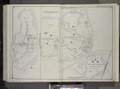 | 6 712 × 4 980 (95,63 MG) | Fæ | GWToolset: Creating mediafile for Fæ. Tranche 3 3501-5495 (repairs) @ 4 May 2014, 10:46 BST |
Lêergebruik
Die volgende bladsy gebruik dié lêer: