
Lêer:Caliphate 750.jpg

Grootte van hierdie voorskou: 719 × 600 piksels. Ander resolusies: 288 × 240 piksels | 576 × 480 piksels | 1 000 × 834 piksels.
Oorspronklike lêer (1 000 × 834 piksels, lêergrootte: 185 KG, MIME-tipe: image/jpeg)
Opsomming
| Beskrywing |
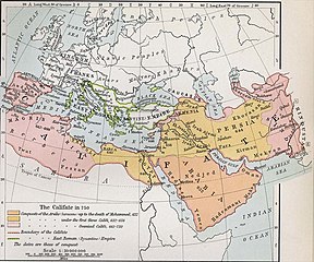
English: Map of the Umayyad Caliphate in 750 CE. |
| Datum | map by William R. Shepherd (12 June 1871 – 7 June 1934). |
| Bron | |
| Outeur | Sheperd, William R.; Historical Atlas; New York: Henry Holt and Company, 1911. 53. |
| Ander weergawes |
[]
|


Lisensiëring
This media file is in the public domain in the United States. This applies to U.S. works where the copyright has expired, often because its first publication occurred prior to January 1, 1929, and if not then due to lack of notice or renewal. See this page for further explanation.
|
 | |
 |
This image might not be in the public domain outside of the United States; this especially applies in the countries and areas that do not apply the rule of the shorter term for US works, such as Canada, Mainland China (not Hong Kong or Macao), Germany, Mexico, and Switzerland. The creator and year of publication are essential information and must be provided. See Wikipedia:Public domain and Wikipedia:Copyrights for more details.
|
Lêergeskiedenis
Klik op die datum/tyd om te sien hoe die lêer destyds gelyk het.
| Datum/Tyd | Duimnael | Dimensies | Gebruiker | Opmerking | |
|---|---|---|---|---|---|
| huidig | 14:24, 2 Mei 2010 | | 1 000 × 834 (185 KG) | Feydey | {{Information |Description={{en|1=Map of the Caliphate in 750.}} |Source=* http://www.shadowedrealm.com/maps/political/view/the_caliphate * http://www.shadowedrealm.com/maps/political/ |Author=Sheperd, William R. Historical Atlas. New York: Henry Holt and |
Lêergebruik
Die volgende bladsy gebruik dié lêer:
Globale lêergebruik
Die volgende ander wiki's gebruik hierdie lêer:
- Gebruik in el.wikipedia.org
- Gebruik in en.wikipedia.org
- Gebruik in et.wikipedia.org
- Gebruik in eu.wikipedia.org
- Gebruik in fa.wikipedia.org
- Gebruik in hu.wikipedia.org
- Gebruik in hy.wikipedia.org
- Gebruik in id.wikipedia.org
- Gebruik in it.wikipedia.org
- Gebruik in ja.wikipedia.org
- Gebruik in ko.wikipedia.org
- Gebruik in nl.wikipedia.org
- Gebruik in pl.wikipedia.org
- Gebruik in pnb.wikipedia.org
- Gebruik in ru.wikipedia.org
- Gebruik in sl.wikipedia.org
- Gebruik in ur.wikipedia.org
- Gebruik in uz.wikipedia.org