
Lêer:Division of Gaul - 511.jpg

Oorspronklike lêer (1 241 × 1 136 piksels, lêergrootte: 346 KG, MIME-tipe: image/jpeg)
Opsomming
| Beskrywing |
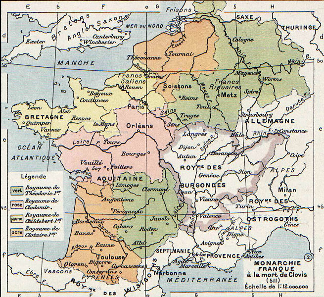
English: The map comes from Vidal-Lablache, Atlas général d'histoire et de géographie (1894). It shows Gaul in 511 AD.
Français : Monarchie franque à la mort de Clovis (511). Paul Vidal de La Blache, Atlas général d'histoire et de géographie (1894). |
||||||||||||||||||||
| Datum | |||||||||||||||||||||
| Bron | Vidal-Lablache, Atlas général d'histoire et de géographie (1894) | ||||||||||||||||||||
| Outeur |
|
||||||||||||||||||||

Lisensiëring
This image is in the public domain because it is a mere mechanical scan or photocopy of a public domain original, or – from the available evidence – is so similar to such a scan or photocopy that no copyright protection can be expected to arise. The original itself is in the public domain for the following reason:
This tag is designed for use where there may be a need to assert that any enhancements (eg brightness, contrast, colour-matching, sharpening) are in themselves insufficiently creative to generate a new copyright. It can be used where it is unknown whether any enhancements have been made, as well as when the enhancements are clear but insufficient. For known raw unenhanced scans you can use an appropriate {{PD-old}} tag instead. For usage, see Commons:When to use the PD-scan tag.  | ||||
Oorspronklike oplaailogboek
- 2007-08-19 21:33 Srnec 1241×1136×8 (353954 bytes) The map comes from Vidal-Lablache, ''Atlas général d'histoire et de géographie'' (1894). {{PD-art-life-70}}
Lêergeskiedenis
Klik op die datum/tyd om te sien hoe die lêer destyds gelyk het.
| Datum/Tyd | Duimnael | Dimensies | Gebruiker | Opmerking | |
|---|---|---|---|---|---|
| huidig | 08:26, 3 Januarie 2008 | | 1 241 × 1 136 (346 KG) | Laurens~commonswiki | {{Information |Description={{en|The map comes from Vidal-Lablache, ''Atlas général d'histoire et de géographie'' (1894).}} |Source=Transfered from [http://en.wikipedia.org en.wikipedia] Transfer was stated to be made by User:laurens. |Date=2007-08- |
Lêergebruik
Die volgende bladsy gebruik dié lêer:
Globale lêergebruik
Die volgende ander wiki's gebruik hierdie lêer:
- Gebruik in arz.wikipedia.org
- Gebruik in azb.wikipedia.org
- Gebruik in be.wikipedia.org
- Gebruik in bg.wikipedia.org
- Gebruik in ca.wikipedia.org
- Gebruik in cs.wikipedia.org
- Gebruik in de.wikipedia.org
- Gebruik in el.wikipedia.org
- Gebruik in en.wikipedia.org
- Gebruik in fa.wikipedia.org
- Gebruik in fi.wikipedia.org
- Gebruik in fr.wikipedia.org
- Gebruik in gl.wikipedia.org
- Gebruik in hr.wikipedia.org
- Gebruik in hy.wikipedia.org
- Gebruik in id.wikipedia.org
- Gebruik in it.wikipedia.org
- Gebruik in ja.wikipedia.org
- Gebruik in ko.wikipedia.org
- Gebruik in mk.wikipedia.org
- Gebruik in pl.wikipedia.org
- Gebruik in ru.wikipedia.org
- Gebruik in sh.wikipedia.org
Wys meer globale gebruik van die lêer.