
Lêer:Dixie Highway Map.png
Grootte van hierdie voorskou: 215 × 599 piksels. Ander resolusies: 86 × 240 piksels | 565 × 1 575 piksels.
Oorspronklike lêer (565 × 1 575 piksels, lêergrootte: 353 KG, MIME-tipe: image/png)
| Beskrywing |
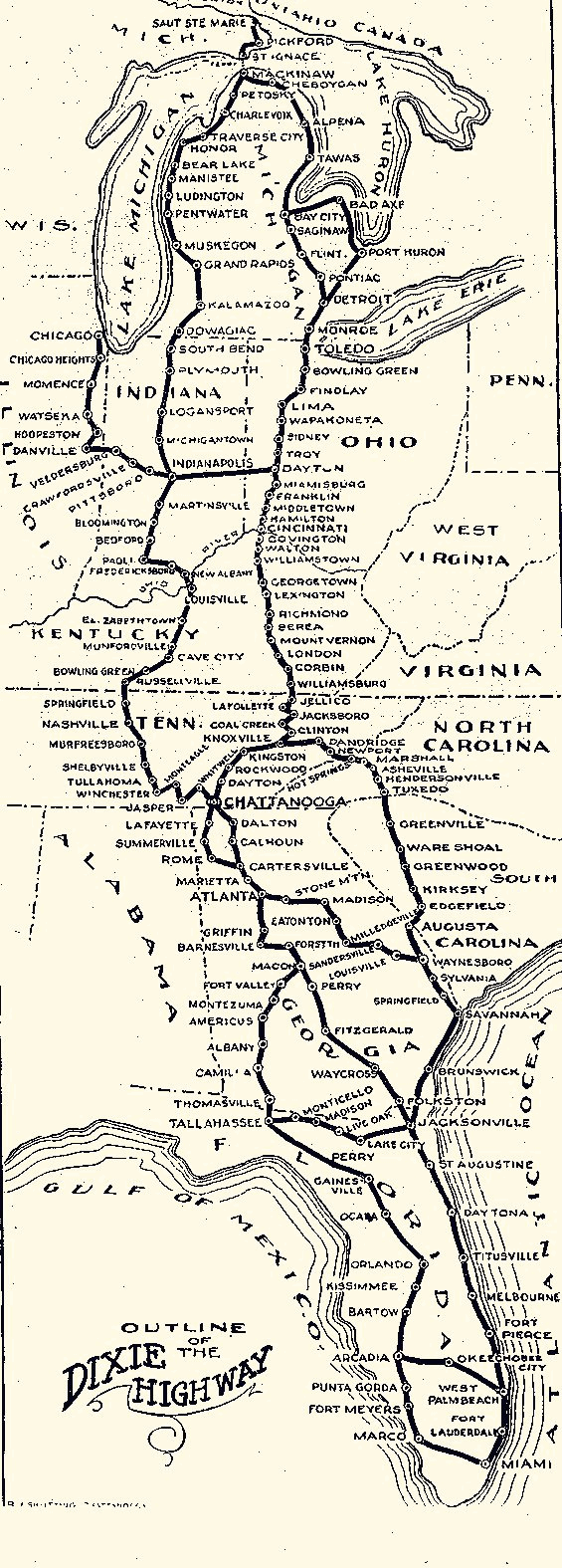
English: Map of the Dixie Highway |
| Datum | (UTC) |
| Bron | |
| Outeur |
|
| This is a retouched picture, which means that it has been digitally altered from its original version. Modifications: Converted to grayscale and to PNG format. The original can be viewed here: Dixie Highway Map.gif:
|
This media file is in the public domain in the United States. This applies to U.S. works where the copyright has expired, often because its first publication occurred prior to January 1, 1929, and if not then due to lack of notice or renewal. See this page for further explanation.
|
 | |
 |
This image might not be in the public domain outside of the United States; this especially applies in the countries and areas that do not apply the rule of the shorter term for US works, such as Canada, Mainland China (not Hong Kong or Macao), Germany, Mexico, and Switzerland. The creator and year of publication are essential information and must be provided. See Wikipedia:Public domain and Wikipedia:Copyrights for more details.
|
Oorspronklike oplaailogboek
This image is a derivative work of the following images:
- File:Dixie_Highway_Map.gif licensed with PD-US
- 2009-01-31T16:12:47Z Tbook 565x1575 (45441 Bytes) {{Information |Description={{en|1=Map of the Dixie Highway}} |Source=Village of Homewood Heritage Committee |Author=Village of Homewood Heritage Committee |Date=1915 |Permission= |other_versions= }} [[Category:Maps]]
Uploaded with derivativeFX
Lêergeskiedenis
Klik op die datum/tyd om te sien hoe die lêer destyds gelyk het.
| Datum/Tyd | Duimnael | Dimensies | Gebruiker | Opmerking | |
|---|---|---|---|---|---|
| huidig | 17:18, 13 September 2010 | 565 × 1 575 (353 KG) | Burpelson AFB | {{Information |Description={{en|1=Map of the Dixie Highway}} |Source=*File:Dixie_Highway_Map.gif |Date=2010-09-13 17:17 (UTC) |Author=*File:Dixie_Highway_Map.gif: Dixie Highway Association *derivative work: ~~~ |Permission= |other_versions= }} |
Lêergebruik
Die volgende bladsy gebruik dié lêer:
Globale lêergebruik
Die volgende ander wiki's gebruik hierdie lêer:
- Gebruik in en.wikipedia.org
- Gebruik in www.wikidata.org