
Lêer:Federal subjects of Russia by population dencity.svg

Size of this PNG preview of this SVG file: 800 × 434 piksels. Ander resolusies: 320 × 173 piksels | 640 × 347 piksels | 1 024 × 555 piksels | 1 280 × 694 piksels | 2 560 × 1 388 piksels | 5 000 × 2 710 piksels.
Oorspronklike lêer (SVG-lêer, normaalweg 5 000 × 2 710 piksels, lêergrootte: 240 KG)
Crimea is Ukraine

|
The boundaries on this map show the de facto situation. This is just one of several different views on the subject (see COM:NPOV). |
Opsomming
| Beskrywing |
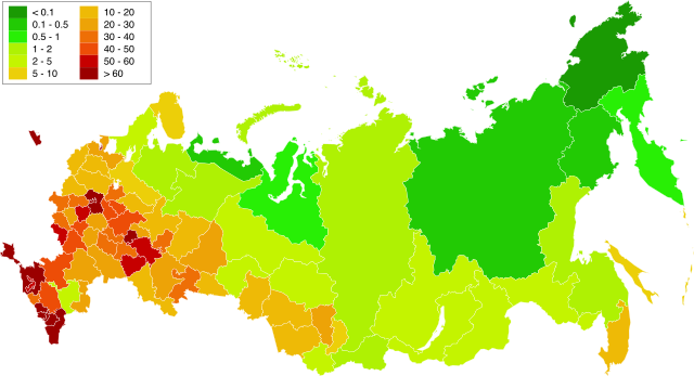
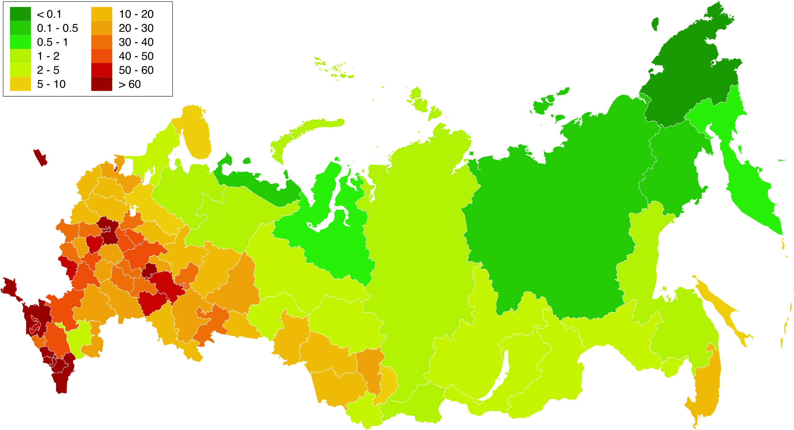
English: Map of population density in the subjects of the Russian Federation. The population density of Arkhangelsk Oblast and Tyumen Oblast was calculated together with the population and area of the respective Autonomous Okrugs belonging to them.
Русский: Карта плотности населения в субъектах Российской Федерации. При расчёте плотностей населения Архангельской и Тюменской области учитывались площади и населения входящих в них автономных округов. |
| Datum | 1.02.2010 20:39:08 MSK |
| Bron | Russia - blank map (2009-01).svg |
| Outeur | Eie werk. Original uploader was Алексей Глушков at ru.wikipedia |
| Ander weergawes |
Other views related to this image
|

.svg)
Lisensiëring
| Ek, die outeursreghouer van hierdie werk, stel dit hiermee in die publieke domein vry. Dit geld wêreldwyd. In sommige lande is dit dalk nie wettiglik moontlik nie. Indien so: Ek verleen aan enigiemand die reg om hierdie werk te gebruik vir enige doel, sonder voorwaardes, tensy sulke voorwaardes deur die wet vereis word. |
Lêergeskiedenis
Klik op die datum/tyd om te sien hoe die lêer destyds gelyk het.
| Datum/Tyd | Duimnael | Dimensies | Gebruiker | Opmerking | |
|---|---|---|---|---|---|
| huidig | 16:58, 20 Maart 2019 | | 5 000 × 2 710 (240 KG) | Gajmar | Kaluga Oblast |
| 20:46, 19 Maart 2019 |  | 5 000 × 2 710 (240 KG) | Gajmar | new colour scheme | |
| 20:17, 19 Maart 2019 |  | 5 000 × 2 710 (236 KG) | Gajmar | update (01.01.2019) | |
| 15:39, 3 Maart 2013 |  | 1 650 × 1 000 (141 KG) | Gajmar | 1.01.2013 | |
| 16:53, 28 Mei 2011 |  | 1 650 × 1 000 (140 KG) | Gajmar | Update the data according to Russian census of 2010 (as of October 14). Indications of population density changed in Karachay-Cherkess Republic, Republic of Mari El, Leningrad Oblast and the Jewish Autonomous Oblast. / Обновление данных с | |
| 18:22, 1 Februarie 2010 |  | 1 650 × 1 000 (109 KG) | Алексей Глушков | {{Information |Description={{en|1=Population density map in subjects of the Russian Federation. At calculation of population density Arkhangelsk and the Tyumen region the areas and the population of autonomous regions entering into them were considered.}} |
Lêergebruik
Die volgende bladsy gebruik dié lêer:
Globale lêergebruik
Die volgende ander wiki's gebruik hierdie lêer:
- Gebruik in ar.wikipedia.org
- Gebruik in az.wikipedia.org
- Gebruik in bg.wikipedia.org
- Gebruik in de.wikipedia.org
- Gebruik in es.wikipedia.org
- Gebruik in eu.wikipedia.org
- Gebruik in fa.wikipedia.org
- Gebruik in hu.wikipedia.org
- Gebruik in kk.wikipedia.org
- Gebruik in pnb.wikipedia.org
- Gebruik in ps.wikipedia.org
- Gebruik in ru.wikipedia.org
- Gebruik in te.wikipedia.org
- Gebruik in zh.wikipedia.org