
Lêer:Global subducted slabs USGS.png

Grootte van hierdie voorskou: 800 × 421 piksels. Ander resolusies: 320 × 169 piksels | 640 × 337 piksels | 1 024 × 539 piksels | 1 280 × 674 piksels | 2 400 × 1 264 piksels.
Oorspronklike lêer (2 400 × 1 264 piksels, lêergrootte: 2,72 MG, MIME-tipe: image/png)
Opsomming
| Beskrywing |
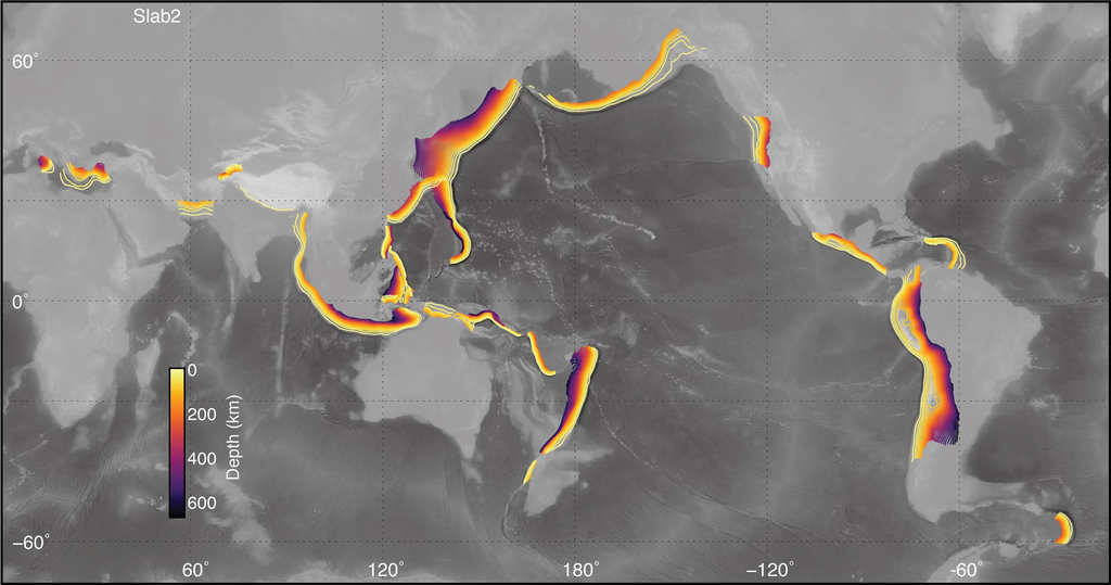
English: Map of subducted slabs, contoured by depth, for most active subduction zones around the globe. Map produced by Gavin P. Hayes (USGS). |
| Datum | |
| Bron | https://www.usgs.gov/media/images/global-distribution-models-included-slab2 |
| Outeur | Gavin P. Hayes |
Lisensiëring
This image is in the public domain in the United States because it only contains materials that originally came from the United States Geological Survey, an agency of the United States Department of the Interior. For more information, see the official USGS copyright policy.
|
Lêergeskiedenis
Klik op die datum/tyd om te sien hoe die lêer destyds gelyk het.
| Datum/Tyd | Duimnael | Dimensies | Gebruiker | Opmerking | |
|---|---|---|---|---|---|
| huidig | 16:32, 13 Maart 2020 | | 2 400 × 1 264 (2,72 MG) | Mikenorton | Uploaded a work by Gavin P. Hayes from https://www.usgs.gov/media/images/global-distribution-models-included-slab2 with UploadWizard |
Lêergebruik
Die volgende bladsy gebruik dié lêer:
Globale lêergebruik
Die volgende ander wiki's gebruik hierdie lêer:
- Gebruik in ban.wikipedia.org
- Gebruik in bn.wikipedia.org
- Gebruik in de.wikipedia.org
- Gebruik in en.wikipedia.org
- Gebruik in es.wikipedia.org
- Gebruik in fr.wikipedia.org
- Gebruik in id.wikipedia.org
- Gebruik in it.wikipedia.org
- Gebruik in it.wikibooks.org
- Gebruik in it.wikiversity.org
- Gebruik in mk.wikipedia.org
- Gebruik in ru.wikipedia.org
- Gebruik in tl.wikipedia.org
- Gebruik in tr.wikipedia.org
- Gebruik in zh.wikipedia.org