
Lêer:Gulf of Saint Lawrence.jpg
Geen hoër resolusie is beskikbaar nie.
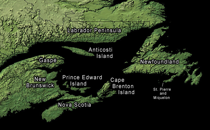
Gulf_of_Saint_Lawrence.jpg (734 × 456 piksels, lêergrootte: 99 KG, MIME-tipe: image/jpeg)
Opsomming
Land-cover imagery from USGS's National Map Server archive copy at the Wayback Machine. Photoshop file with layers is located here in case any modifications or translations are needed.
Lisensiëring
This work is in the public domain in the United States because it is a work prepared by an officer or employee of the United States Government as part of that person’s official duties under the terms of Title 17, Chapter 1, Section 105 of the US Code.
Note: This only applies to original works of the Federal Government and not to the work of any individual U.S. state, territory, commonwealth, county, municipality, or any other subdivision. This template also does not apply to postage stamp designs published by the United States Postal Service since 1978. (See § 313.6(C)(1) of Compendium of U.S. Copyright Office Practices). It also does not apply to certain US coins; see The US Mint Terms of Use.
|
 | |
| Hierdie lêer is geïdentifiseer as vry van bekende beperkings onder kopiereg, insluitend alle verwante en naburige regte. | ||
Oorspronklike oplaailogboek
The original description page was here. All following user names refer to en.wikipedia.
- 2006-01-30 20:43 Kelisi 734×456× (74652 bytes) same, with spelling correction
- 2005-10-23 17:10 Interiot 734×456× (101750 bytes) inc font size of "Gaspé"
- 2005-10-23 15:38 Interiot 734×456× (101801 bytes) more font tweaks
- 2005-10-23 15:32 Interiot 734×457× (101689 bytes) larger font
- 2005-10-23 15:26 Interiot 781×481× (111492 bytes) Map of the [[Gulf of Saint Lawrence]]. Land-cover imagery from [[USGS]]'s [http://nmviewogc.cr.usgs.gov/viewer.htm National Map Server].
Lêergeskiedenis
Klik op die datum/tyd om te sien hoe die lêer destyds gelyk het.
| Datum/Tyd | Duimnaelskets | Dimensies | Gebruiker | Opmerking | |
|---|---|---|---|---|---|
| huidig | 22:23, 17 September 2012 | | 734 × 456 (99 KG) | OgreBot | (BOT): Reverting to most recent version before archival |
| 22:23, 17 September 2012 |  | 734 × 456 (73 KG) | OgreBot | (BOT): Uploading old version of file from en.wikipedia; originally uploaded on 2006-01-30 20:43:20 by Kelisi | |
| 22:23, 17 September 2012 |  | 734 × 456 (99 KG) | OgreBot | (BOT): Uploading old version of file from en.wikipedia; originally uploaded on 2005-10-23 15:38:39 by Interiot | |
| 22:23, 17 September 2012 |  | 734 × 457 (99 KG) | OgreBot | (BOT): Uploading old version of file from en.wikipedia; originally uploaded on 2005-10-23 15:32:33 by Interiot | |
| 22:23, 17 September 2012 |  | 781 × 481 (109 KG) | OgreBot | (BOT): Uploading old version of file from en.wikipedia; originally uploaded on 2005-10-23 15:26:46 by Interiot | |
| 08:05, 29 Januarie 2006 |  | 734 × 456 (99 KG) | Kpjas | Land-cover imagery from USGS's [http://nmviewogc.cr.usgs.gov/viewer.htm National Map Server]. Photoshop file with layers is located [http://paperlined.org/apps/wikipedia/src_data/Gulf_of_Saint_Lawrence.psd here] in case any modifications or trans |
Lêergebruik
Die volgende bladsy gebruik dié lêer:
Globale lêergebruik
Die volgende ander wiki's gebruik hierdie lêer:
- Gebruik in az.wikipedia.org
- Gebruik in ba.wikipedia.org
- Gebruik in be.wikipedia.org
- Gebruik in bs.wikipedia.org
- Gebruik in ce.wikipedia.org
- Gebruik in cs.wikipedia.org
- Gebruik in el.wikipedia.org
- Gebruik in en.wikipedia.org
- Gebruik in fa.wikipedia.org
- Gebruik in fr.wikipedia.org
- Gebruik in he.wikipedia.org
- Gebruik in id.wikipedia.org
- Gebruik in it.wikipedia.org
- Gebruik in ko.wikipedia.org
- Gebruik in lv.wikipedia.org
- Gebruik in pl.wikipedia.org
- Gebruik in ro.wikipedia.org
- Gebruik in ru.wikipedia.org
- Gebruik in sh.wikipedia.org
- Gebruik in sk.wikipedia.org
- Gebruik in sr.wikipedia.org
- Gebruik in uk.wikipedia.org
- Gebruik in zh.wikipedia.org