
Lêer:Jan Janssonius - Japan.jpg

Grootte van hierdie voorskou: 725 × 599 piksels. Ander resolusies: 290 × 240 piksels | 581 × 480 piksels | 929 × 768 piksels | 1 239 × 1 024 piksels | 2 477 × 2 048 piksels | 6 726 × 5 561 piksels.
Oorspronklike lêer (6 726 × 5 561 piksels, lêergrootte: 8,04 MG, MIME-tipe: image/jpeg)
Opsomming
| Beskrywing |
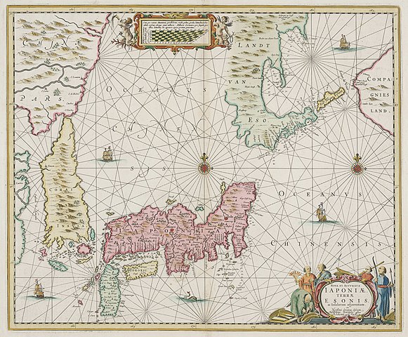
English: Nova et Accurata Iaponiae, Terrae Esonis, ac Insularum Adjacentium ex Novißimâ detectione descriptio Amstelodami Vendibilis apud P. Schenk, et G. Valk. C. P. [A New and Accurate Description of Japan, the Land of Eso (Hokkaido), and Adjacent Islands from the Newest Discovery for Sale with Legal Permission at the Shop of Pieter Schenk and Gerard Valk in Amsterdam]
A 455×550 mm copper-engraved map incorporating accounts (and gross misinformation) from the Dutch East India Company's expeditions to the Bonins under Matthew Quast in 1639 and to Hokkaido and the Kurils under Martin de Vries in 1643. |
|||||||||||||||||||||||||
| Datum | [1652 original] | |||||||||||||||||||||||||
| Bron | Helmink Antique Maps | |||||||||||||||||||||||||
| Outeur |
|
|||||||||||||||||||||||||
| Ander weergawes |
|
|||||||||||||||||||||||||
.jpg)

,_NG-501-86.jpg)
.jpeg)
Lisensiëring
|
This work is in the public domain in its country of origin and other countries and areas where the copyright term is the author's life plus 100 years or fewer. | |
| Hierdie lêer is geïdentifiseer as vry van bekende beperkings onder kopiereg, insluitend alle verwante en naburige regte. | |
| Annotations | This image is annotated: View the annotations at Commons |
Lêergeskiedenis
Klik op die datum/tyd om te sien hoe die lêer destyds gelyk het.
| Datum/Tyd | Duimnael | Dimensies | Gebruiker | Opmerking | |
|---|---|---|---|---|---|
| huidig | 10:52, 24 September 2010 | | 6 726 × 5 561 (8,04 MG) | Jan Arkesteijn | {{Information |Description={{en|1=Nova et accurata Iaponiae. Map by Jan Janssonius based on the exploration of the Dutch vessels of Maarten Gerritszoon Vries in 1643 *edition 1700 *45.5 x 55.0 cm *copper engraving}} |Source=[http://www.helmink.com/Antique |
Lêergebruik
Die volgende bladsy gebruik dié lêer:
Globale lêergebruik
Die volgende ander wiki's gebruik hierdie lêer:
- Gebruik in en.wikipedia.org