
Lêer:Location-of-Liancourt-rocks-en.png
Grootte van hierdie voorskou: 800 × 400 piksels. Ander resolusies: 320 × 160 piksels | 938 × 469 piksels.
Oorspronklike lêer (938 × 469 piksels, lêergrootte: 286 KG, MIME-tipe: image/png)

|
This locator map image could be re-created using vector graphics as an SVG file. This has several advantages; see Commons:Media for cleanup for more information. If an SVG form of this image is available, please upload it and afterwards replace this template with
{{vector version available|new image name}}.
It is recommended to name the SVG file “Location-of-Liancourt-rocks-en.svg”—then the template Vector version available (or Vva) does not need the new image name parameter. |
Opsomming
| Beskrywing |
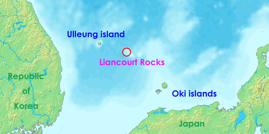
English: Liancourt rocks, in Japan called Takeshima and in North and South Korea called Dokdo (Tokto).
Ido: Liancourt roki, en Japonia nomata Takeshima ed en Nord e Sud-Korea nomata Dokto (Tokto). |
||||
| Datum | 12 Mei 2006 (original upload date) | ||||
| Bron | http://www.demis.nl/wms/mapclip.htm | ||||
| Outeur | demis.nl | ||||
| Toestemming (Hergebruik van die lêer) |
|
Lêergeskiedenis
Klik op die datum/tyd om te sien hoe die lêer destyds gelyk het.
| Datum/Tyd | Duimnaelskets | Dimensies | Gebruiker | Opmerking | |
|---|---|---|---|---|---|
| huidig | 05:36, 17 Julie 2008 | | 938 × 469 (286 KG) | Ponta2 | Reverted to version as of 19:08, 6 April 2008 |
| 12:03, 16 Julie 2008 |  | 800 × 400 (332 KG) | 쿠도군 | ||
| 19:08, 6 April 2008 |  | 938 × 469 (286 KG) | Eurodollers | == Summary == {{Information |Description={{en|Location of Liancourt Rocks, where Korea and Japan claim that Liancourt rocks is their own territory.}} |Source= http://www.demis.nl/wms/mapclip.htm |Date= 12 May 2006 (original upload date) |Author= demis.nl | |
| 01:41, 5 Junie 2007 |  | 640 × 320 (57 KG) | Tene~commonswiki | Optimised (0;r) | |
| 09:43, 18 Oktober 2006 |  | 640 × 320 (60 KG) | Conscious | Reverted to earlier revision | |
| 14:00, 12 Mei 2006 |  | 640 × 320 (60 KG) | LERK | Location of Liancourt Rocks, where Korea and Japan claim that Liancourt rocks is their own territoriy. {{demis-pd}} Category:Maps of disputed territories Category:Maps of Korea Category:Islands of Korea Category:Maps of Japan [[Category:Is |
Lêergebruik
Die volgende bladsy gebruik dié lêer:
Globale lêergebruik
Die volgende ander wiki's gebruik hierdie lêer:
- Gebruik in ar.wikipedia.org
- Gebruik in bat-smg.wikipedia.org
- Gebruik in bh.wikipedia.org
- Gebruik in ca.wikipedia.org
- Gebruik in de.wikipedia.org
- Gebruik in en.wikipedia.org
- Gebruik in eo.wikipedia.org
- Gebruik in es.wikipedia.org
- Gebruik in fa.wikipedia.org
- Gebruik in fi.wikipedia.org
- Gebruik in fr.wikipedia.org
- Gebruik in he.wikipedia.org
- Gebruik in hi.wikipedia.org
- Gebruik in id.wikipedia.org
- Gebruik in it.wikipedia.org
- Gebruik in ja.wikibooks.org
- Gebruik in lt.wikipedia.org
- Gebruik in ms.wikipedia.org
- Gebruik in nl.wikipedia.org
- Gebruik in no.wikipedia.org
- Gebruik in pa.wikipedia.org
- Gebruik in pl.wikipedia.org
- Gebruik in pt.wikipedia.org
- Gebruik in ro.wikipedia.org
- Gebruik in simple.wikipedia.org
Wys meer globale gebruik van die lêer.