
Lêer:Mangareva Island.jpg

Grootte van hierdie voorskou: 605 × 599 piksels. Ander resolusies: 242 × 240 piksels | 485 × 480 piksels | 646 × 640 piksels.
Oorspronklike lêer (646 × 640 piksels, lêergrootte: 128 KG, MIME-tipe: image/jpeg)
Opsomming
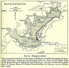
Old map of Mangareva, Gambier Islands.
Source: http://www.lib.utexas.edu/maps/historical/pacific_islands_1943_1945/mangareva_island.jpg PD, see http://www.lib.utexas.edu/maps/faq.html#3.html
Lisensiëring
This file is in the public domain because it has been taken from a collection of public domain maps at the University of Texas Library
|
Lêergeskiedenis
Klik op die datum/tyd om te sien hoe die lêer destyds gelyk het.
| Datum/Tyd | Duimnael | Dimensies | Gebruiker | Opmerking | |
|---|---|---|---|---|---|
| huidig | 16:30, 3 Oktober 2006 | | 646 × 640 (128 KG) | Ratzer | http://www.lib.utexas.edu/maps/historical/pacific_islands_1943_1945/mangareva_island.jpg PD, see http://www.lib.utexas.edu/maps/faq.html#3.html |
Lêergebruik
Die volgende bladsy gebruik dié lêer:
Globale lêergebruik
Die volgende ander wiki's gebruik hierdie lêer:
- Gebruik in ca.wikipedia.org
- Gebruik in de.wikipedia.org
- Gebruik in en.wikipedia.org
- Gebruik in es.wikipedia.org
- Gebruik in fr.wikipedia.org
- Gebruik in mk.wikipedia.org
- Gebruik in mrj.wikipedia.org
- Gebruik in nl.wikipedia.org
- Gebruik in pl.wikipedia.org
- Gebruik in pt.wikipedia.org
- Gebruik in ru.wikipedia.org
- Gebruik in uk.wikipedia.org