
Lêer:Map of Hawaii NA.png
Grootte van hierdie voorskou: 776 × 600 piksels. Ander resolusies: 311 × 240 piksels | 621 × 480 piksels | 994 × 768 piksels | 1 280 × 989 piksels | 2 122 × 1 640 piksels.
Oorspronklike lêer (2 122 × 1 640 piksels, lêergrootte: 370 KG, MIME-tipe: image/png)
Opsomming
| Beskrywing |
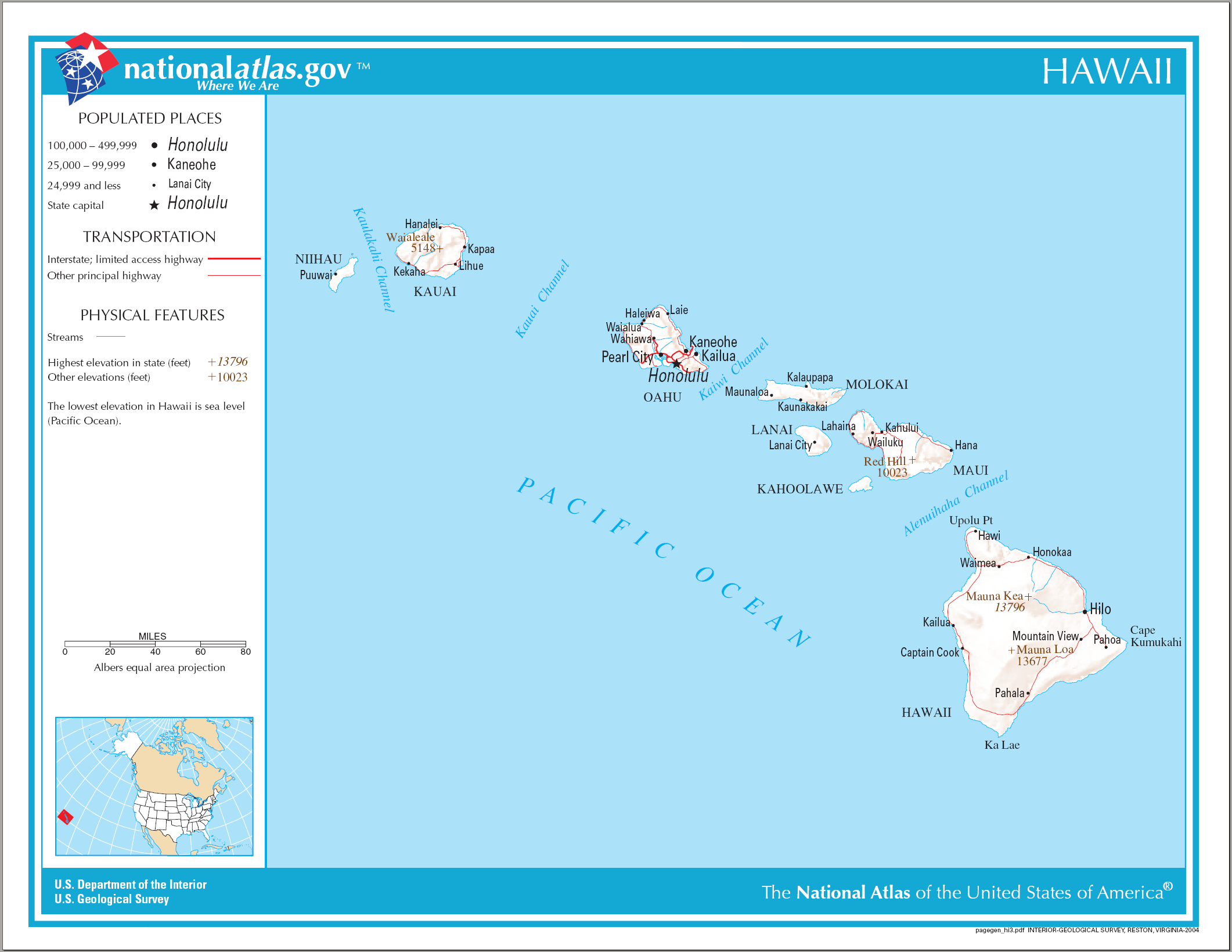
English: Reference Map of Hawaii. |
| Datum | |
| Bron | |
| Outeur | National Atlas of the United States |
| Toestemming (Hergebruik van die lêer) |
Public domain |
Lisensiëring
This map was obtained from an edition of the National Atlas of the United States. Like almost all works of the U.S. federal government, works from the National Atlas are in the public domain in the United States.
Online access: NationalAtlas.gov | 1970 print edition: Library of Congress, Perry-Castañeda Library
|
Lêergeskiedenis
Klik op die datum/tyd om te sien hoe die lêer destyds gelyk het.
| Datum/Tyd | Duimnaelskets | Dimensies | Gebruiker | Opmerking | |
|---|---|---|---|---|---|
| huidig | 10:26, 15 Augustus 2006 | | 2 122 × 1 640 (370 KG) | Huebi~commonswiki | {{Information| |Description=Map of Hawaii |Source=[http://www.nationalatlas.gov National Atlas] }} Category:Maps of the United States Category:Maps of Hawaii {{PD-USGov-Atlas}} |
Lêergebruik
Die volgende bladsy gebruik dié lêer:
Globale lêergebruik
Die volgende ander wiki's gebruik hierdie lêer:
- Gebruik in als.wikipedia.org
- Gebruik in cs.wikipedia.org
- Gebruik in da.wikipedia.org
- Gebruik in de.wikipedia.org
- Gebruik in en.wikipedia.org
- Gebruik in es.wikipedia.org
- Gebruik in fa.wikipedia.org
- Gebruik in he.wikipedia.org
- Gebruik in hr.wikipedia.org
- Gebruik in hr.wiktionary.org
- Gebruik in hsb.wikipedia.org
- Gebruik in hu.wikipedia.org
- Gebruik in incubator.wikimedia.org
- Gebruik in it.wikipedia.org
- Gebruik in kn.wikipedia.org
- Gebruik in ko.wikipedia.org
- Gebruik in mk.wikipedia.org
- Gebruik in ml.wikipedia.org
- Gebruik in nl.wikipedia.org
- Gebruik in pam.wikipedia.org
- Gebruik in pdc.wikipedia.org
- Gebruik in pl.wikipedia.org
- Gebruik in pt.wikipedia.org
- Gebruik in ru.wikivoyage.org
- Gebruik in sh.wikipedia.org
- Gebruik in sr.wikipedia.org
- Gebruik in sv.wikipedia.org
- Gebruik in sw.wikipedia.org
- Gebruik in te.wikipedia.org
- Gebruik in zea.wikipedia.org