
Lêer:Map of Nicobar and Andaman Islands-en.svg

Size of this PNG preview of this SVG file: 263 × 598 piksels. Ander resolusies: 105 × 240 piksels | 211 × 480 piksels | 337 × 768 piksels | 450 × 1 024 piksels | 900 × 2 048 piksels | 906 × 2 060 piksels.
Oorspronklike lêer (SVG-lêer, normaalweg 906 × 2 060 piksels, lêergrootte: 621 KG)
Opsomming
| Beskrywing | |
| Datum | |
| Bron | Eie werk. Self-made in Inkscape. Based on the 1976 CIA Indian Ocean Atlas (Andaman nicobar 76.jpg); bathymetry and topography from SRTM30_PLUS. |
| Outeur | Oona Räisänen (Mysid) |
| Ander weergawes |
Derivative works of this file: |
| SVG genesis |
Lisensiëring
Ek, die outeursreghouer van hierdie werk, publiseer dit onder die volgende lisensie:
Hierdie lêer is gelisensieer onder die Creative Commons Erkenning-Insgelyks Deel 3.0 Onoorgedraagde lisensie.
- U is vry:
- om te deel – die werk kopieer, versprei en deurgee
- om te hermeng – om die werk aan te pas
- Onder die volgende voorwaardes:
- naamsvermelding – U moet die nodige krediet gee, 'n skakel na die lisensie verskaf en aandui of daar veranderinge aangebring is. U mag dit op enige redelike manier doen, maar nie op enige manier wat daarop dui dat die lisensiegewer u of u gebruik onderskryf nie.
- insgelyks – As u die materiaal hermix, transformeer of voortbou, moet u u bydraes versprei onder die dieselfde of versoenbare lisensie as die oorspronklike.

|
Toestemming word verleen tot die kopiëring, verspreiding en/of wysiging van hierdie dokument onder die voorwaardes van die GNU-lisensie vir vrye dokumentasie, weergawe 1.2 of enige latere weergawe uitgegee deur die Stigting vir Vrye Sagteware, sonder Invariante Dele, geen Voorbladtekste en geen Agterbladtekste. 'n Kopie van hierdie lisensie is ingesluit in die afdeling getiteld GNU Free Documentation License. |
U kan die lisensie van u keuse kies.
Lêergeskiedenis
Klik op die datum/tyd om te sien hoe die lêer destyds gelyk het.
| Datum/Tyd | Duimnael | Dimensies | Gebruiker | Opmerking | |
|---|---|---|---|---|---|
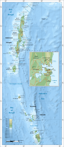
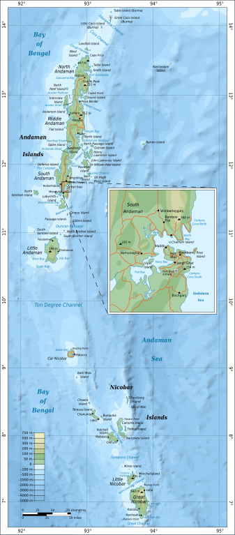
| huidig | 16:24, 15 September 2010 | | 906 × 2 060 (621 KG) | Mysid | {{Information |Description={{en|1=Map of the Nicobar and Andaman Islands.}} |Source={{own}}. Self-made in Inkscape. Based on the 1976 CIA Indian Ocean Atlas (File:Andaman nicobar 76.jpg); bathymetry and topography from SRTM30_PLUS. |Author=[[w:User:M |
Lêergebruik
Die volgende bladsy gebruik dié lêer:
Globale lêergebruik
Die volgende ander wiki's gebruik hierdie lêer:
- Gebruik in ar.wikipedia.org
- Gebruik in ast.wikipedia.org
- Gebruik in az.wikipedia.org
- Gebruik in be.wikipedia.org
- Gebruik in br.wikipedia.org
- Gebruik in ca.wikipedia.org
- Gebruik in en.wikipedia.org
- Gebruik in eo.wikipedia.org
- Gebruik in es.wikipedia.org
- Gebruik in fi.wikipedia.org
- Gebruik in fi.wiktionary.org
- Gebruik in fr.wikipedia.org
- Gebruik in ga.wikipedia.org
- Gebruik in gom.wikipedia.org
- Gebruik in ha.wikipedia.org
- Gebruik in hi.wikipedia.org
- Gebruik in hi.wikibooks.org
- Gebruik in hy.wikipedia.org
- Gebruik in it.wikipedia.org
- Gebruik in ja.wikipedia.org
- Gebruik in mr.wikipedia.org
- Gebruik in oc.wikipedia.org
- Gebruik in pl.wikipedia.org
- Gebruik in pnb.wikipedia.org
- Gebruik in ru.wikipedia.org
- Gebruik in sw.wikipedia.org
- Gebruik in te.wikipedia.org
- Gebruik in tg.wikipedia.org
- Gebruik in uk.wikipedia.org
- Gebruik in ur.wikipedia.org
- Gebruik in www.wikidata.org
- Gebruik in zh.wikipedia.org