
Lêer:Map of Shootings at Kent State University in 1970.jpg
Grootte van hierdie voorskou: 770 × 600 piksels. Ander resolusies: 308 × 240 piksels | 616 × 480 piksels | 986 × 768 piksels | 1 200 × 935 piksels.
Oorspronklike lêer (1 200 × 935 piksels, lêergrootte: 364 KG, MIME-tipe: image/jpeg)
Opsomming
| Beskrywing |
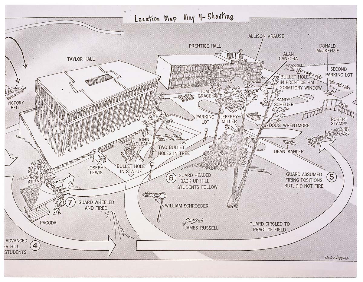
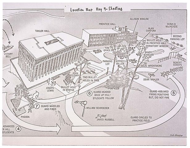
English: This is a printed map detailing the locations of structures, troop movements, bullet hole locations, and locations of casualties at the Kent State shooting of May 4, 1970. |
|||
| Datum | 5/04/1970 | |||
| Bron | https://catalog.archives.gov/id/596837 | |||
| Outeur | President (1969-1974 : Nixon). President's Commission on Campus Unrest. | |||
| Toestemming (Hergebruik van die lêer) |
|
Lisensiëring
This work is in the public domain in the United States because it is a work prepared by an officer or employee of the United States Government as part of that person’s official duties under the terms of Title 17, Chapter 1, Section 105 of the US Code.
Note: This only applies to original works of the Federal Government and not to the work of any individual U.S. state, territory, commonwealth, county, municipality, or any other subdivision. This template also does not apply to postage stamp designs published by the United States Postal Service since 1978. (See § 313.6(C)(1) of Compendium of U.S. Copyright Office Practices). It also does not apply to certain US coins; see The US Mint Terms of Use.
|
 | |
| Hierdie lêer is geïdentifiseer as vry van bekende beperkings onder kopiereg, insluitend alle verwante en naburige regte. | ||
Lêergeskiedenis
Klik op die datum/tyd om te sien hoe die lêer destyds gelyk het.
| Datum/Tyd | Duimnaelskets | Dimensies | Gebruiker | Opmerking | |
|---|---|---|---|---|---|
| huidig | 01:26, 9 Junie 2008 | | 1 200 × 935 (364 KG) | Goldfishbutt | {{Information |Description={{en|1=This is a printed map detailing the locations of structures, troop movements, bullet hole locations, and locations of casualties at the Kent State shooting of May 4, 1970.}} |Source=http://arcweb.archives.gov/arc/arch_res |
Lêergebruik
Die volgende bladsy gebruik dié lêer:
Globale lêergebruik
Die volgende ander wiki's gebruik hierdie lêer:
- Gebruik in de.wikipedia.org
- Gebruik in en.wikipedia.org
- Gebruik in en.wikibooks.org
- Gebruik in en.wikiquote.org
- Gebruik in fr.wikipedia.org
- Gebruik in he.wikipedia.org
- Gebruik in it.wikipedia.org
- Gebruik in ja.wikipedia.org
- Gebruik in nl.wikipedia.org
- Gebruik in no.wikipedia.org
- Gebruik in sv.wikipedia.org
- Gebruik in zh.wikipedia.org