
Lêer:Matabeleland.svg

Size of this PNG preview of this SVG file: 250 × 228 piksels. Ander resolusies: 263 × 240 piksels | 526 × 480 piksels | 842 × 768 piksels | 1 123 × 1 024 piksels | 2 246 × 2 048 piksels.
Oorspronklike lêer (SVG-lêer, normaalweg 250 × 228 piksels, lêergrootte: 30 KG)
Opsomming
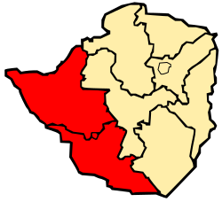
| Beskrywing | Map of Zimbabwe showing Matabeleland |
| Datum | |
| Bron | Eie werk |
| Outeur | Mangwanani using Inkscape |
Lisensiëring
| Ek, die outeursreghouer van hierdie werk, stel dit hiermee in die publieke domein vry. Dit geld wêreldwyd. In sommige lande is dit dalk nie wettiglik moontlik nie. Indien so: Ek verleen aan enigiemand die reg om hierdie werk te gebruik vir enige doel, sonder voorwaardes, tensy sulke voorwaardes deur die wet vereis word. |
Lêergeskiedenis
Klik op die datum/tyd om te sien hoe die lêer destyds gelyk het.
| Datum/Tyd | Duimnael | Dimensies | Gebruiker | Opmerking | |
|---|---|---|---|---|---|
| huidig | 17:26, 4 Maart 2008 | | 250 × 228 (30 KG) | Mangwanani | == Summary == {{Information |Description=Map of Zimbabwe showing Matabeleland |Source=self made |Date=3 March 2008 |Author=Mangwanani using Inkscape |Permission= |other_versions= }} == Licensing == {{PD-self}} Category:Maps of Zimbabwe |
Lêergebruik
Die volgende bladsy gebruik dié lêer:
Globale lêergebruik
Die volgende ander wiki's gebruik hierdie lêer:
- Gebruik in be.wikipedia.org
- Gebruik in bn.wikipedia.org
- Gebruik in en.wikipedia.org
- Gebruik in fa.wikipedia.org
- Gebruik in fr.wikipedia.org
- Gebruik in fr.wiktionary.org
- Gebruik in id.wikipedia.org
- Gebruik in incubator.wikimedia.org
- Gebruik in it.wikipedia.org
- Gebruik in it.wikivoyage.org
- Gebruik in ko.wikipedia.org
- Gebruik in kv.wikipedia.org
- Gebruik in lt.wikipedia.org
- Gebruik in nl.wikipedia.org
- Gebruik in pt.wikipedia.org
- Gebruik in ru.wikipedia.org
- Gebruik in sn.wikipedia.org
- Gebruik in tr.wikipedia.org
- Gebruik in tum.wikipedia.org
- Gebruik in uk.wikipedia.org
- Gebruik in ur.wikipedia.org
- Gebruik in xh.wikipedia.org
- Gebruik in zh.wikipedia.org