
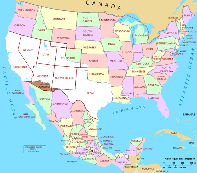
Lêer:Mexican Cession in Mexican View.PNG

Grootte van hierdie voorskou: 680 × 599 piksels. Ander resolusies: 272 × 240 piksels | 545 × 480 piksels | 872 × 768 piksels | 1 068 × 941 piksels.
Oorspronklike lêer (1 068 × 941 piksels, lêergrootte: 135 KG, MIME-tipe: image/png)

|
This map image could be re-created using vector graphics as an SVG file. This has several advantages; see Commons:Media for cleanup for more information. If an SVG form of this image is available, please upload it and afterwards replace this template with
{{vector version available|new image name}}.
It is recommended to name the SVG file “Mexican Cession in Mexican View.svg”—then the template Vector version available (or Vva) does not need the new image name parameter. |
Opsomming
| Beskrywing | Mexican Cession in Mexican View |
| Datum | 01/07/2009 |
| Bron | U.S._Territorial_Acquisitions.png |
| Outeur | United States federal government (en:User:Black and White converted it from JPEG to PNG and retouched it) |
| Toestemming (Hergebruik van die lêer) |
This map was obtained from an edition of the National Atlas of the United States. Like almost all works of the U.S. federal government, works from the National Atlas are in the public domain. |
Lisensiëring
| Ek, die outeursreghouer van hierdie werk, stel dit hiermee in die publieke domein vry. Dit geld wêreldwyd. In sommige lande is dit dalk nie wettiglik moontlik nie. Indien so: Ek verleen aan enigiemand die reg om hierdie werk te gebruik vir enige doel, sonder voorwaardes, tensy sulke voorwaardes deur die wet vereis word. |
Lêergeskiedenis
Klik op die datum/tyd om te sien hoe die lêer destyds gelyk het.
| Datum/Tyd | Duimnael | Dimensies | Gebruiker | Opmerking | |
|---|---|---|---|---|---|
| huidig | 21:02, 22 September 2011 | | 1 068 × 941 (135 KG) | Hpav7 | ajustes |
| 04:39, 18 Januarie 2010 |  | 1 068 × 941 (135 KG) | Jaimiko | Se agrego la totalidad del territorio Mexicano y la division de los estados de Mexico. Was added the entire Mexican territory and the division of states of Mexico. | |
| 21:59, 1 Julie 2009 |  | 1 066 × 721 (107 KG) | Jaimiko | {{Information |Description= Mexican Cession in Mexican View |Source= U.S._Territorial_Acquisitions.png |Date= 01/07/2009 |Author=United States federal government (en:User:Black and White converted it from JPEG to PNG and retouched it) |Permission=This map |
Lêergebruik
Die volgende bladsy gebruik dié lêer:
Globale lêergebruik
Die volgende ander wiki's gebruik hierdie lêer:
- Gebruik in ca.wikipedia.org
- Gebruik in cs.wikipedia.org
- Gebruik in de.wikipedia.org
- Gebruik in en.wikipedia.org
- Gebruik in es.wikipedia.org
- Gebruik in fa.wikipedia.org
- Gebruik in fi.wikipedia.org
- Gebruik in fr.wikipedia.org
- Gebruik in hr.wikipedia.org
- Gebruik in hu.wikipedia.org
- Gebruik in it.wikipedia.org
- Gebruik in ja.wikipedia.org
- Gebruik in ms.wikipedia.org
- Gebruik in sh.wikipedia.org
- Gebruik in ta.wikipedia.org
- Gebruik in th.wikipedia.org
- Gebruik in zh-min-nan.wikipedia.org
- Gebruik in zh.wikipedia.org