
Lêer:Mount Mazama eruption timeline.PNG
Oorspronklike lêer (250 × 841 piksels, lêergrootte: 187 KG, MIME-tipe: image/png)
Opsomming
| Beskrywing |
|
| Bron | http://pubs.usgs.gov/fs/2002/fs092-02/ (saved as PNG) |
| Outeur | U.S. GEOLOGICAL SURVEY and the NATIONAL PARK SERVICE |
| Ander weergawes |
    |

|
This geology image could be re-created using vector graphics as an SVG file. This has several advantages; see Commons:Media for cleanup for more information. If an SVG form of this image is available, please upload it and afterwards replace this template with
{{vector version available|new image name}}.
It is recommended to name the SVG file “Mount Mazama eruption timeline.svg”—then the template Vector version available (or Vva) does not need the new image name parameter. |
Lisensiëring
This image is in the public domain in the United States because it only contains materials that originally came from the United States Geological Survey, an agency of the United States Department of the Interior. For more information, see the official USGS copyright policy.
|
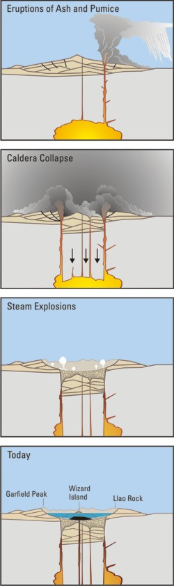
Crater Lake is an example, it is located in Oregen and was made from a valcano, making a caldera.
Lêergeskiedenis
Klik op die datum/tyd om te sien hoe die lêer destyds gelyk het.
| Datum/Tyd | Duimnael | Dimensies | Gebruiker | Opmerking | |
|---|---|---|---|---|---|
| huidig | 05:24, 29 Maart 2006 | 250 × 841 (187 KG) | Jkelly | Source: http://pubs.usgs.gov/fs/2002/fs092-02/ (saved as PNG) Author: U.S. GEOLOGICAL SURVEY and the NATIONAL PARK SERVICE Description: <blockquote>Cataclysmic eruption to present. Eruptions of ash and pumice: The cataclysmic eruption started from a ve |
Lêergebruik
Die volgende bladsy gebruik dié lêer:
Globale lêergebruik
Die volgende ander wiki's gebruik hierdie lêer:
- Gebruik in an.wikipedia.org
- Gebruik in ar.wikipedia.org
- Gebruik in ast.wikipedia.org
- Gebruik in br.wikipedia.org
- Gebruik in ce.wikipedia.org
- Gebruik in cy.wikipedia.org
- Gebruik in de.wikipedia.org
- Gebruik in en.wikipedia.org
- Gebruik in en.wikiversity.org
- Gebruik in eo.wikipedia.org
- Gebruik in es.wikipedia.org
- Gebruik in fa.wikipedia.org
- Gebruik in fi.wikipedia.org
- Gebruik in fr.wikipedia.org
- Gebruik in id.wikipedia.org
- Gebruik in it.wikipedia.org
- Gebruik in ja.wikipedia.org
- Gebruik in ko.wikipedia.org
- Gebruik in lv.wikipedia.org
- Gebruik in min.wikipedia.org
- Gebruik in mk.wikipedia.org
- Gebruik in ml.wikipedia.org
- Gebruik in pt.wikipedia.org
- Gebruik in ru.wikipedia.org
- Gebruik in simple.wikipedia.org
- Gebruik in sk.wikipedia.org
- Gebruik in sr.wikipedia.org
- Gebruik in su.wikipedia.org
- Gebruik in vi.wikipedia.org
- Gebruik in www.wikidata.org