
Lêer:NorthNatalWarTheatre, colour, crop.png
Oorspronklike lêer (730 × 1 006 piksels, lêergrootte: 90 KG, MIME-tipe: image/png)
Opsomming
| Beskrywing |
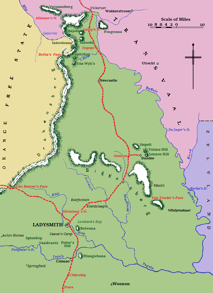
English: Map of the North Natal war theatre during the Second Anglo-Boer War.
Colony of Natal
Hills and mountains
Orange Free State
Transvaal (or South African Republic)
Zululand
|
| Datum | |
| Bron | Anonymous (1910) A Handbook of the Boer War - With General Map of South Africa and 18 Sketch Maps and Plans, London & Aldershot: Gale & Polden Ltd |
| Outeur | Anonymous - marketed by Sutton, Praed & Co (cartographer) |
| Ander weergawes |
  |
| Objekligging | | Hierdie en ander beelde in: OpenStreetMap |
|---|
Lisensiëring
This media file is in the public domain in the United States. This applies to U.S. works where the copyright has expired, often because its first publication occurred prior to January 1, 1929, and if not then due to lack of notice or renewal. See this page for further explanation.
|
 | |
 |
This image might not be in the public domain outside of the United States; this especially applies in the countries and areas that do not apply the rule of the shorter term for US works, such as Canada, Mainland China (not Hong Kong or Macao), Germany, Mexico, and Switzerland. The creator and year of publication are essential information and must be provided. See Wikipedia:Public domain and Wikipedia:Copyrights for more details.
|
This work was first published in South Africa and is now in the public domain because its copyright protection has expired by virtue of the Copyright Act No. 98 of 1978, amended 2002. The work meets one of the following criteria:
A South African work that is in the public domain in South Africa according to this rule is in the public domain in the U.S. only if it was in the public domain in South Africa in 1996, e.g. if it was published before 1946 and no copyright was registered in the U.S. (This is the effect of 17 USC 104A with its critical date of January 1, 1996.) |
 |
| This image comes from the Project Gutenberg archives. This is an image that has come from a book or document for which the American copyright has expired and this image is in the public domain in the United States and possibly other countries.
This eBook is for the use of anyone anywhere at no cost and with almost no restrictions whatsoever. You may copy it, give it away or re-use it under the terms of the Project Gutenberg License included with this eBook or online at www.gutenberg.net. |
Lêergeskiedenis
Klik op die datum/tyd om te sien hoe die lêer destyds gelyk het.
| Datum/Tyd | Duimnael | Dimensies | Gebruiker | Opmerking | |
|---|---|---|---|---|---|
| huidig | 19:41, 14 Augustus 2019 | | 730 × 1 006 (90 KG) | JMK | clarity |
| 20:03, 16 Mei 2019 |  | 730 × 1 006 (64 KG) | JMK | clarity | |
| 17:19, 24 April 2019 |  | 730 × 1 006 (60 KG) | JMK | {{Information |description ={{en|1=Map of the North Natal war theatre during the Second Anglo-Boer War.}} |date =1910 |source =http://www.gutenberg.org/files/15699/15699-h/15699-h.htm |author ={{anonymous}} }} Category:Maps of the Second Boer War |
Lêergebruik
Die volgende bladsy gebruik dié lêer:
Globale lêergebruik
Die volgende ander wiki's gebruik hierdie lêer:
- Gebruik in en.wikipedia.org
- Gebruik in eo.wikipedia.org
- Gebruik in ru.wikipedia.org
- Gebruik in uk.wikipedia.org