
Lêer:Port Phillip 10,000.PNG
Geen hoër resolusie is beskikbaar nie.
Port_Phillip_10,000.PNG (514 × 523 piksels, lêergrootte: 20 KG, MIME-tipe: image/png)

|
Hierdie beeld is deur middel van 'n botskrip na die Wikimedia Commons geskuif vanaf en.wikipedia. Alle broninligting is steeds aanwesig, maar die beeld moet deur 'n gebruiker hersien word. Dit is ook moontlik dat daar foute in een/alle afdelings kan voorkom; die inligting op hierdie bladsy moet nie as betroubaar beskou word nie. Die beeld behoort dus nie gebruik te word tot tyd en wyl dit hersien en gekorrigeer is nie. Wanneer dit hersien is, kan hierdie sjabloon verwyder word. Sien hier onder vir meer details. Hersien nou! |
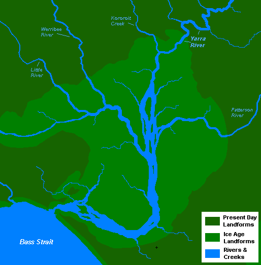
Opsomming
| Beskrywing |
English: A very basic map of the port phillip plains approximately 10-12 thousand years ago, prior to sea level rise that filled the area of land now known as Port Phillip, and the course of the Yarra River as it emptied into Bass Strait. More exact details regarding the course of the Yarra River in the port phillip plains are needed. |
| Datum | 13 November 2008 (original upload date) |
| Bron | Eie werk |
| Outeur | Nick carson at Engels Wikipedia |
Lisensiëring
| This work has been released into the public domain by its author, Nick carson at Engels Wikipedia. This applies worldwide. In sommige lande is dit dalk nie wettiglik moontlik nie. Indien so: Nick carson grants anyone the right to use this work for any purpose, without any conditions, unless such conditions are required by law. |
Oorspronklike oplaailogboek
The original description page was here. All following user names refer to en.wikipedia.
- 2008-11-13 14:20 Nick carson 514×523 (20321 bytes) A very basic map of the port phillip plains approximately 10-12 thousand years ago, prior to sea level rise that filled the area of land now known as Port Phillip, and the course of the Yarra River as it emptied into Bass Strait. More exact details regard
Lêergeskiedenis
Klik op die datum/tyd om te sien hoe die lêer destyds gelyk het.
| Datum/Tyd | Duimnael | Dimensies | Gebruiker | Opmerking | |
|---|---|---|---|---|---|
| huidig | 19:12, 7 Januarie 2012 | | 514 × 523 (20 KG) | BotMultichillT | {{BotMoveToCommons|en.wikipedia|year={{subst:CURRENTYEAR}}|month={{subst:CURRENTMONTHNAME}}|day={{subst:CURRENTDAY}}}} == {{int:filedesc}} == {{Information |description={{en|1=A very basic map of the port phillip plains approximately 10-12 thousand years |
Lêergebruik
Die volgende bladsy gebruik dié lêer:
Globale lêergebruik
Die volgende ander wiki's gebruik hierdie lêer:
- Gebruik in en.wikipedia.org
- Gebruik in sr.wikipedia.org
- Gebruik in zh.wikipedia.org