
Lêer:Second Saudi State Big.png
Grootte van hierdie voorskou: 734 × 599 piksels. Ander resolusies: 294 × 240 piksels | 588 × 480 piksels | 941 × 768 piksels | 1 254 × 1 024 piksels | 2 000 × 1 633 piksels.
Oorspronklike lêer (2 000 × 1 633 piksels, lêergrootte: 322 KG, MIME-tipe: image/png)
Opsomming
| Beskrywing |
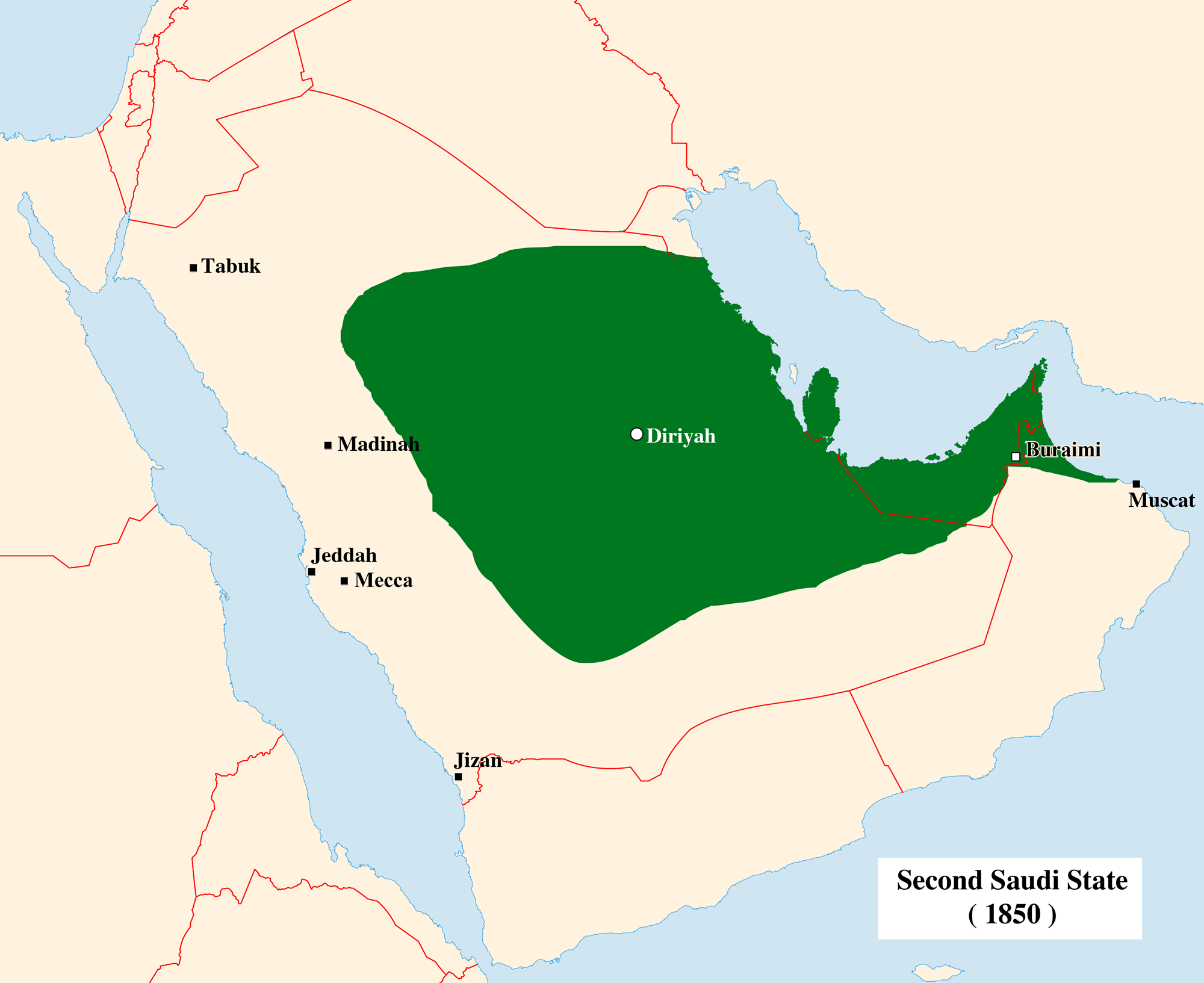
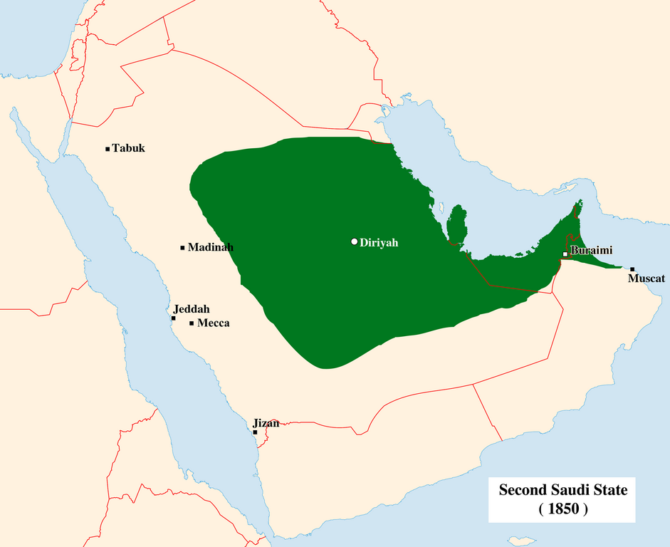
English: Second Saudi State ( 1850 ) |
| Datum | |
| Bron | My self , using this file and this file |
| Outeur | Ameen Mohammad |
| Ander weergawes |
Derivative works of this file: Second Saudi State Big cs.png Derivative works of this file: Second Saudi State Big-ko.png |
.svg)
Lisensiëring
Ek, die outeursreghouer van hierdie werk, publiseer dit onder die volgende lisensie:
Hierdie lêer is gelisensieer onder die Creative Commons Erkenning-Insgelyks Deel 3.0 Onoorgedraagde lisensie.
- U is vry:
- om te deel – die werk kopieer, versprei en deurgee
- om te hermeng – om die werk aan te pas
- Onder die volgende voorwaardes:
- naamsvermelding – U moet die nodige krediet gee, 'n skakel na die lisensie verskaf en aandui of daar veranderinge aangebring is. U mag dit op enige redelike manier doen, maar nie op enige manier wat daarop dui dat die lisensiegewer u of u gebruik onderskryf nie.
- insgelyks – As u die materiaal hermix, transformeer of voortbou, moet u u bydraes versprei onder die dieselfde of versoenbare lisensie as die oorspronklike.

|
Toestemming word verleen tot die kopiëring, verspreiding en/of wysiging van hierdie dokument onder die voorwaardes van die GNU-lisensie vir vrye dokumentasie, weergawe 1.2 of enige latere weergawe uitgegee deur die Stigting vir Vrye Sagteware, sonder Invariante Dele, geen Voorbladtekste en geen Agterbladtekste. 'n Kopie van hierdie lisensie is ingesluit in die afdeling getiteld GNU Free Documentation License. |
U kan die lisensie van u keuse kies.
Lêergeskiedenis
Klik op die datum/tyd om te sien hoe die lêer destyds gelyk het.
| Datum/Tyd | Duimnael | Dimensies | Gebruiker | Opmerking | |
|---|---|---|---|---|---|
| huidig | 17:53, 21 November 2023 | | 2 000 × 1 633 (322 KG) | Vyvagaba | Reverted to version as of 12:42, 20 June 2010 (UTC) |
| 16:24, 19 September 2023 |  | 1 526 × 972 (225 KG) | Vyvagaba | Corrected map to remove Qatar, Oman and Trucial States, see Omani Empire, Trucial States and British Protectorate treaties in the Persian Gulf | |
| 12:42, 20 Junie 2010 |  | 2 000 × 1 633 (322 KG) | Ameen Mohammad | {{Information |Description={{en|1=Second Saudi State ( 1850 )}} |Source=My self , using this file and this file |Author=Ameen Mohammad |Date=June 20 , |
.svg)
Lêergebruik
Die volgende bladsy gebruik dié lêer:
Globale lêergebruik
Die volgende ander wiki's gebruik hierdie lêer:
- Gebruik in az.wikipedia.org
- Gebruik in bn.wikipedia.org
- Gebruik in da.wikipedia.org
- Gebruik in en.wikipedia.org
- Gebruik in es.wikipedia.org
- Gebruik in fa.wikipedia.org
- Gebruik in fi.wikipedia.org
- Gebruik in fr.wikipedia.org
- Gebruik in id.wikipedia.org
- Gebruik in it.wikipedia.org
- Gebruik in ka.wikipedia.org
- Gebruik in ko.wikipedia.org
- Gebruik in la.wikipedia.org
- Gebruik in nl.wikipedia.org
- Gebruik in nn.wikipedia.org
- Gebruik in no.wikipedia.org
- Gebruik in pnb.wikipedia.org
- Gebruik in pt.wikipedia.org
- Gebruik in ru.wikipedia.org
- Gebruik in sh.wikipedia.org
- Gebruik in sr.wikipedia.org
- Gebruik in tr.wikipedia.org
- Gebruik in uk.wikipedia.org
- Gebruik in vi.wikipedia.org