
Lêer:Viceroyalty of the New Spain 1800 (without Philippines).png

Oorspronklike lêer (1 600 × 1 192 piksels, lêergrootte: 645 KG, MIME-tipe: image/png)

|
File:Mapa del Virreinato de la Nueva España (1794).svg is a vector version of this file. It should be used in place of this PNG file when not inferior.
File:Viceroyalty of the New Spain 1800 (without Philippines).png → File:Mapa del Virreinato de la Nueva España (1794).svg
For more information, see Help:SVG. |
.svg) |
Opsomming
| Beskrywing |
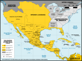
Español: Mapa del Virreinato de Nueva España en 1800. Sin incluir los territorios de ultramar en el Oceano Pacífico.
English: Map of the Viceroyalty of New Spain in 1800. Not including the viceroyalty's overseas territories in the Pacific Ocean.
Territorial organization of the Viceroyalty of New Spain (1535-1786)
Territorial organization of the Viceroyalty of New Spain (1786-1821)
|
||
| Datum | |||
| Bron |
A map created using information from the United States Geological Survey, an agency of the United States Department of Interior 1800, 1810, 1820 and from the Secretary of the Public Education of Mexico (Secretaría de Educación Pública de México) with 500 años de documentos COMMENT on 1 April 2015: The map above is still captioned "1810," instead of 1800. This is unfortunate and confusing, because in 1803 Spanish Louisiana was tranferred (to France and then) to the United States, so it makes the map appear to contain a serious error. ‘’’COMMENT on 13 August 2023: Date on the map above has still not been corrected to the actual year it represents, 1800. This leads to several inaccuracies, including for example misrepresentation of the size of the United States. In 1803 Ohio became a state, so it was no longer a territory by 1810. Such things were quickly changing in the 1800s, and the date on this map should be corrected.’’’ |
||
| Outeur | Giggette | ||
| Ander weergawes |
|

.png)
.png)
.png)
| Kameraligging | | Hierdie en ander beelde in: OpenStreetMap |
|---|
.png¶ms=019.409500_N_-099.130700_E_globe:Earth_type:camera_type:satellite_region:MX_heading:0.00&language=af)
Lisensiëring
- U is vry:
- om te deel – die werk kopieer, versprei en deurgee
- om te hermeng – om die werk aan te pas
- Onder die volgende voorwaardes:
- naamsvermelding – U moet die nodige krediet gee, 'n skakel na die lisensie verskaf en aandui of daar veranderinge aangebring is. U mag dit op enige redelike manier doen, maar nie op enige manier wat daarop dui dat die lisensiegewer u of u gebruik onderskryf nie.
- insgelyks – As u die materiaal hermix, transformeer of voortbou, moet u u bydraes versprei onder die dieselfde of versoenbare lisensie as die oorspronklike.

|
Toestemming word verleen tot die kopiëring, verspreiding en/of wysiging van hierdie dokument onder die voorwaardes van die GNU-lisensie vir vrye dokumentasie, weergawe 1.2 of enige latere weergawe uitgegee deur die Stigting vir Vrye Sagteware, sonder Invariante Dele, geen Voorbladtekste en geen Agterbladtekste. 'n Kopie van hierdie lisensie is ingesluit in die afdeling getiteld GNU Free Documentation License. |
Lêergeskiedenis
Klik op die datum/tyd om te sien hoe die lêer destyds gelyk het.
| Datum/Tyd | Duimnael | Dimensies | Gebruiker | Opmerking | |
|---|---|---|---|---|---|
| huidig | 02:42, 21 November 2016 | | 1 600 × 1 192 (645 KG) | Giggette | Clearest |
| 20:14, 1 Junie 2014 |  | 1 600 × 1 192 (635 KG) | Giggette | Details | |
| 20:39, 13 Mei 2014 |  | 1 600 × 1 192 (634 KG) | Giggette | Details | |
| 20:34, 13 Mei 2014 |  | 1 450 × 1 080 (557 KG) | Giggette | Improving the design, adding elements | |
| 23:39, 11 Mei 2014 |  | 1 501 × 1 117 (549 KG) | Giggette | Adding details, lakes, cities, information | |
| 22:41, 11 Mei 2014 |  | 1 501 × 1 116 (538 KG) | Giggette | Adding missed provinces and clarifying information | |
| 17:54, 6 Mei 2014 |  | 1 501 × 1 116 (517 KG) | Giggette | Details | |
| 22:38, 4 Mei 2014 |  | 1 302 × 971 (450 KG) | Giggette | Details | |
| 17:33, 6 Junie 2013 |  | 1 450 × 1 084 (500 KG) | Giggette | mistake | |
| 17:30, 6 Junie 2013 |  | 1 450 × 1 084 (490 KG) | Giggette | {{Information |Description ={{en|1=x}} |Source ={{own}} |Author =Giggette |Date = |Permission = |other_versions = }} |
Lêergebruik
Daar is geen bladsye wat dié lêer gebruik nie.
Globale lêergebruik
Die volgende ander wiki's gebruik hierdie lêer:
- Gebruik in cs.wikipedia.org
- Gebruik in en.wikipedia.org
- Gebruik in fr.wikipedia.org
- Gebruik in gl.wikipedia.org
.png)