
Lêer:Worldmaphedo.jpg
Geen hoër resolusie is beskikbaar nie.
Worldmaphedo.jpg (700 × 437 piksels, lêergrootte: 57 KG, MIME-tipe: image/jpeg)
Opsomming
| Beskrywing |
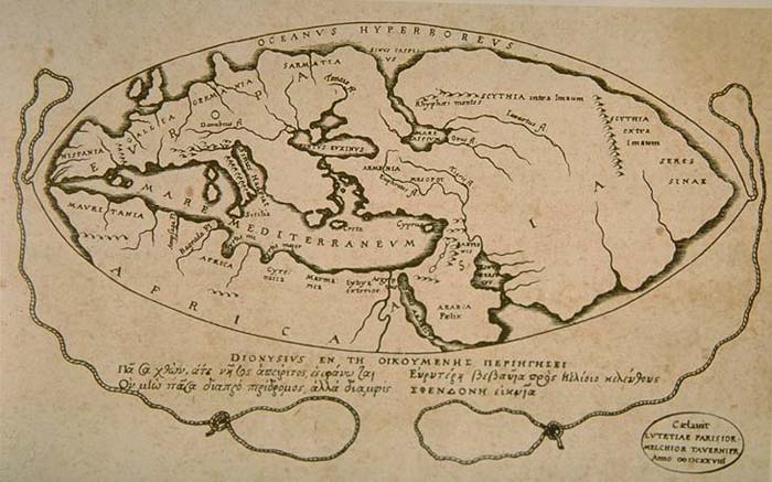
English: World map according to ideas by Posidonius (150-130 B.C.), drawn by 16th century cartographers Petrus Bertius & Melchior Tavernier in 1628. Many of the details in this map couldn't have been known by Posidonius, rather, Bertius and Tavernier show Posidonius' ideas about the positions of the continents. |
|||||||||||||||||||||||||||||||||||||||||||||
| Datum | ||||||||||||||||||||||||||||||||||||||||||||||
| Bron | Armenica | |||||||||||||||||||||||||||||||||||||||||||||
| Outeur |
|
|||||||||||||||||||||||||||||||||||||||||||||

Lisensiëring
|
This work is in the public domain in its country of origin and other countries and areas where the copyright term is the author's life plus 100 years or fewer. This work is in the public domain in the United States because it was published (or registered with the U.S. Copyright Office) before January 1, 1929. | |
| Hierdie lêer is geïdentifiseer as vry van bekende beperkings onder kopiereg, insluitend alle verwante en naburige regte. | |
Oorspronklike oplaailogboek
Transferred from en.wikipedia to Commons by Woudloper using CommonsHelper.
The original description page was here. All following user names refer to en.wikipedia.
- 2007-02-08 14:26 Artaxiad 700×437×8 (57932 bytes) World map according to Posidonius (150-130 B.C.) {{GFDL-Armenica}}
Lêergeskiedenis
Klik op die datum/tyd om te sien hoe die lêer destyds gelyk het.
| Datum/Tyd | Duimnael | Dimensies | Gebruiker | Opmerking | |
|---|---|---|---|---|---|
| huidig | 15:22, 20 Mei 2008 | | 700 × 437 (57 KG) | Woudloper | {{Information |Description={{en|World map according to Posidonius (150-130 B.C.) Source: http://www.armenica.org/cgi-bin/history/en/getHistory.cgi?3=1==Historical%20maps==1=3=AAA}} |Source=Transferred from [http://en.wikipedia.org en.wikipedia]; transfer |
Lêergebruik
Die volgende bladsy gebruik dié lêer:
Globale lêergebruik
Die volgende ander wiki's gebruik hierdie lêer:
- Gebruik in bn.wikipedia.org
- Gebruik in bs.wikipedia.org
- Gebruik in ca.wikipedia.org
- Gebruik in cs.wikipedia.org
- Gebruik in de.wikipedia.org
- Gebruik in en.wikipedia.org
- Gebruik in es.wikipedia.org
- Gebruik in fa.wikipedia.org
- Gebruik in fr.wikipedia.org
- Gebruik in ha.wikipedia.org
- Gebruik in he.wikipedia.org
- Gebruik in hi.wikibooks.org
- Gebruik in hr.wikipedia.org
- Gebruik in hy.wikipedia.org
- Gebruik in it.wikipedia.org
- Gebruik in ja.wikipedia.org
- Gebruik in lv.wikipedia.org
- Gebruik in nl.wikipedia.org
- Gebruik in no.wikipedia.org
- Gebruik in pnb.wikipedia.org
- Gebruik in sh.wikipedia.org
- Gebruik in sl.wikipedia.org
- Gebruik in sr.wikipedia.org
- Gebruik in th.wikipedia.org
- Gebruik in uk.wikipedia.org
- Gebruik in ur.wikipedia.org
- Gebruik in zh.wikipedia.org