
Gaborone: Verskil tussen weergawes
k Link GA is now handled by Wikidata, removed: {{Link GA|no}} using AWB (10861) |
Uitgebrei |
||
| Lyn 1: | Lyn 1: | ||
{| align="right" cellpadding="2" cellspacing="0" style="border:1px solid #88a; background:#CEDAF2; padding:5px; font-size: 85%; margin: 0 0 0.5em 1em; border-collapse:collapse;" |
|||
{{Infoboks stad |
|||
! align="center" colspan="2" style="color: #FFFFFF; background: #003399; padding: 4px; font-size:170%;" | |
|||
|plaaslike naam=Gaborone |
|||
<span style="font-size:16pt">'''Gaborone'''</span><br /> |
|||
|Afrikaanse naam= |
|||
[[Lêer:Gaborone Montage.png|280px]] |
|||
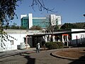
|beeld =Gaboronecitycentre.JPG |
|||
|- style="background: #CEDAF2; text-align:center;border-bottom:1px solid #999" |
|||
|beeldteks= |
|||
| '''Kaart''' |
|||
|beeldgrootte=250px |
|||
|style="border-left:1px solid #999"| '''Wapen''' |
|||
|kaart =BW-Gaborone.png |
|||
|- style="background:white" |
|||
|kaartgrootte=170px |
|||
|rowspan=6| [[Lêer:BW-Gaborone.png|180px|senter]] |
|||
|wapen =Flag of None.svg |
|||
|- style="background: white" |
|||
|wapengrootte=70px |
|||
|style="border-left:1px solid #999"| [[Lêer:Coats of arms of None.svg|75px|senter]] |
|||
|vlag =Flag of None.svg |
|||
|- style="background: #f7f8ff;border-top:1px solid #999; text-align:center;" |
|||
|vlaggrootte=70px |
|||
|style="border-left:1px solid #999"| |
|||
|land =Botswana |
|||
|- style="background: #CEDAF2; text-align:center;" |
|||
|administratiewe gewes =Suid-Oos distrik|Suid-Oos |
|||
|style="border-left:1px solid #999;border-top:1px solid #999"| '''Vlag''' |
|||
|oppervlakte = |
|||
|- style="background: white; border-top:1px solid #999;" |
|||
|hbs =900 |
|||
|style="border-left:1px solid #999"| [[Lêer:Flag of None.svg|90px|senter]] |
|||
|bevolking =208,411 |
|||
|- style="background: #f7f8ff; border-top:1px solid #999; text-align:center;" |
|||
|bevolkingsjaar =2005 |
|||
|style="border-left:1px solid #999"| |
|||
|bevolkingsdigtheid = |
|||
|- style="border-top:1px solid #999;" |
|||
|tydsone =SAST +2 |
|||
| '''Land''' |
|||
|somertyd =Geen |
|||
| style="background: #f7f8ff; text-align:center;" | {{vlagland|Botswana}} |
|||
|burgermeester =Harry Mothei |
|||
|- style="border-top:1px solid #999;" |
|||
|webwerf =Geen |
|||
| '''Distrik''' |
|||
|koördinate = |
|||
| style="background: #f7f8ff; text-align:center;" | Gaborone |
|||
|stigting =1965 |
|||
|- style="border-top:1px solid #999;" |
|||
|etniese groep 1 = |
|||
| '''Koördinate''' |
|||
|etniese groep 1 % = |
|||
| style="background: #f7f8ff; text-align:center;" | {{Koördinate|24|40|S|25|55|O}} |
|||
|etniese groep 2 = |
|||
|- style="border-top:1px solid #999;" |
|||
|etniese groep 2 % = |
|||
| '''Stigting''' |
|||
|etniese groep 3 = |
|||
| style="background: #f7f8ff; text-align:center;" | 1964<ref>{{en}} {{cite web |first=Neil |last=Parsons |title=Botswana History Page 7: Geography |url=http://www.thuto.org/ubh/bw/bhp7.htm |work= Botswana History Pages|publisher=University of Botswana History Department|location= Gaborone, Botswana |date=19 Augustus 1999 |accessdate=4 Augustus 2009}}</ref> |
|||
|etniese groep 3 % = |
|||
|- style="border-top:1px solid #999;" |
|||
|etniese groep ander % = |
|||
| '''Oppervlakte:''' |
|||
|keuse1 =Hoofstad sedert |
|||
| style="background: #f7f8ff" | |
|||
|inhoud keuse1 =1965 |
|||
|- |
|||
|keuse2 = |
|||
| - Totaal |
|||
|inhoud keuse2= |
|||
| style="background: #f7f8ff; text-align:center;" | 169 [[vierkante kilometer|vk km]]<ref>{{en}} {{cite web|title=BOTSWANA STATISTICAL YEAR BOOK 2010|url=http://www.cso.gov.bw/templates/cso/file/File/Botswana%20Statistical%20Year%20Book%202010.PDF|work=Statistics Botswana|publisher=Central Statistics Office|accessdate=25 Februarie 2012|archiveurl=http://www.webcitation.org/65jCFX9lp|archivedate=25 Februarie 2012|location=Gaborone|format=PDF|date=Desember 2011}}</ref> |
|||
|bevolkingkeuse1 = |
|||
|- |
|||
|inhoud bevolkingkeuse1 = |
|||
| '''Hoogte bo seevlak''' |
|||
|bevolkingkeuse2 = |
|||
| style="background: #f7f8ff; text-align:center;" | 1 014 m<ref>{{en}} {{cite web|url=http://www.fallingrain.com/world/BC/09/Gaborone.html|title=Gaborone, Botswana Page|publisher=Falling Rain Genomics, Inc.}}</ref> |
|||
|inhoud bevolkingkeuse2 = |
|||
|- style="border-top:1px solid #999;" |
|||
}} |
|||
|- style="border-top:1px solid #999;" |
|||
|- |
|||
| '''Bevolking:''' |
|||
| style="background: #f7f8ff" | |
|||
|- |
|||
| - Totaal (2011) |
|||
| style="background: #f7f8ff; text-align:center;" | 231 626<ref>{{en}} {{cite web|title=The Population of Towns, Villages and Associated Localities|work=2011 Population and Housing Census|url= http://www.cso.gov.bw/templates/cso/file/File/Population%20of%20Towns%20and%20Villages%20_2011%20PHC_%20Jun%204%202012..pdf|archiveurl=http://www.webcitation.org/68QAYaEFm|archivedate=14 June 2012|accessdate=14 Junie 2012| date=Junie 2012 |publisher=Statistics Botswana|location=Gaborone|format=PDF}}</ref> |
|||
|- |
|||
| - Bevolkingsdigtheid |
|||
| style="background: #f7f8ff; text-align:center;" | 1 400/vk km |
|||
|- |
|||
| '''Tydsone''' |
|||
| style="background: #f7f8ff; text-align:center;" | [[UTC]] +2 |
|||
|- style="border-top:1px solid #999;" |
|||
|- |
|||
| '''Burgemeester''' |
|||
| style="background: #f7f8ff; text-align:center;" | Haskins Nkaigwa<ref>{{en}} {{Cite journal|first=Ephraim |last=Keoreng|title=New Gaborone Mayor seeks power to hire and fire |url=http://www.mmegi.bw/index.php?sid=1&aid=494&dir=2011/October/Wednesday5 |publisher= [[Mmegi|Mmegi Online]] |location= Gaborone, Botswana |date=5 Oktober 2011|accessdate=9 Oktober 2011| volume=28 | issue=148}}</ref> |
|||
|- style="border-top:1px solid #999;" |
|||
|} |
|||
'''Gaborone''' ('''Gaberones''' voor 1969) |
'''Gaborone''' ('''Gaberones''' voor 1969; [[Tswana]]: [χabʊˈrʊnɛ]) is die [[hoofstad]] en grootste stad van [[Botswana]]. Dié stad het 'n bevolking van 231 626 in 2011 gehad (10% van Botswana se bevolking) en het 'n oppervlakte van 169 km². Die stad is in 1964 as beplande stad gestig en dié stad se eerste burgemeester was [[J. D. Jones]]. Dit is ná Kgosi Gaborone, 'n Botswana-[[Kgosi|hoof]], genoem. |
||
[[Lêer:1966 Mayor Gaborone.JPG|left|thumb|J. D. Jones, die eerste burgemeester van Gaberones]] |
|||
[[Lêer:1966 Mayor Gaborone.JPG|duimnael|links|upright|J. D. Jones, die eerste burgemeester van Gaberones]] |
|||
{{saadjie}} |
|||
In 1890 het [[Cecil John Rhodes]] Gaberones gekies om 'n koloniale fort te huisves.<ref>{{en}} {{cite web |title=African cities- Gaborone History |url=http://gaborone.info/php/gabhist.php?name=Gaborone%20History |work= Gaborone.info|publisher=AfricanCities.net |accessdate=4 Augustus 2009}}</ref> In die fort het Rhodes die [[Jameson-inval]] beplan.<ref>{{en}} {{cite book |last1=Hardy |first1=Paula|last2=Firestone |first2=Matthew D. |title=Botswana & Namibia |url=https://books.google.com/?id=HSAs1_B-93YC&lpg=PP1&pg=PA74#v=onepage&q= |accessdate=4 August 2009 |year=2007 |publisher=Lonely Planet |isbn=978-1-74104-760-8 |chapter=Gaborone |chapterurl=https://books.google.com/books?id=HSAs1_B-93YC&lpg=PP1&pg=PA74#v=onepage&q=&f=false |pages=75–88}}</ref> |
|||
In 1965 is die hoofstad van die [[Betsjoeanaland]]-protektoraat van [[Mahikeng|Mafeking]] ná Gaberones geskuif. Oorspronklik is [[Lobatse]] as nuwe hoofstad van die onafhanklike Botswana voorgestel, maar weens sy nabyheid aan 'n varswaterbron, sy ligging aan die spoorlyn ná [[Pretoria]], sy sentrale ligging tussen die plaaslike stamme en sy gebrek aan assosiasie met die omliggende stamme is Gaborone as hoofstad benoem.<ref>{{en}} {{cite book |last1=Seth |first1=Willie |title=Botswana and Its People |accessdate=4 Augustus 2009 |year=2008 |publisher=New Africa Press|isbn=978-0-9814258-7-0 |chapter=Major urban centres |pages=44–46}}</ref> Die stad se naam is in 1969 van Gaberones tot Gaborone verander.<ref>{{en}} {{cite news | title = Regions Given New Spelling | url = https://news.google.com/newspapers?id=7bszAAAAIBAJ&sjid=IfgDAAAAIBAJ&dq=gaborone&pg=7329%2C1913552 | agency = Associated Press | newspaper = Spokane Daily Chronicle | location = Spokane, Washington, USA | date = 22 Desember 1969 | page = 11 | accessdate =11 Julie 2010 }}</ref> |
|||
Gaborone is in die suidweste van Botswana aan die [[Notwanerivier]] sowat 15 km noordoos van die [[grens tussen Suid-Afrika en Botswana]] geleë.<ref>{{en}} {{cite book |last1=Seth |first1=Willie |title=Botswana and Its People |url=https://books.google.com/?id=bR54xeODwCIC&lpg=PA44&pg=PA44#v=onepage&q= |accessdate=4 Augustus 2009 |year=2008 |publisher=Godfrey Mwakikagile |isbn=978-0-9814258-7-0 |chapter=Major urban centres |chapterurl=https://books.google.com/books?id=bR54xeODwCIC&lpg=PA43&pg=PA43#v=onepage&q=&f=false |pages=44–46}}</ref> In dié stad is die parlement van Botswana en dié land se belangrikste lughawe, die [[Sir Seretse Khama Internasionale Lughawe]], geleë. Die [[Suider-Afrikaanse Ontwikkelingsgemeenskap]] se hoofkwartier is ook hier geleë. |
|||
Gaborone vorm sy eie distrik, maar dien ook as hoofstad van die omliggende [[Suid-Oos distrik, Botswana|Suid-Oos-distrik]]. Die plaaslike bevolking verwys dikwels ná die stad as ''Gabs''.<ref>{{en}} {{cite web |first=Purity |last=Njeru |title=History of Gaborone |url=http://www.africanexecutive.com/modules/magazine/articles.php?article=703 |publisher=The African Executive|location= Nairobi, Kenya |year=2009 |accessdate=4 Augustus 2009}}</ref> |
|||
== Fotogalery == |
|||
<center><gallery> |
|||
Lêer:BotswanaParliament.jpg|Botswana se parlament in Gaborone |
|||
Lêer:GABS-UB Courtyard.JPG|Die Universiteit van Botswana |
|||
Lêer:Department of Taxes and Attorney General's Chambers Building.jpg|Departement van Belasting en die Prokureur-generaal se Kamergebou |
|||
Lêer:Aeropuerto Internacional Sir Seretse Khama de Gaborone, Botswana.jpg|Die [[Sir Seretse Khama Internasionale Lughawe]] |
|||
Lêer:Southern African Development Community Headquarters 20 oct 2009.jpg|Hoofkwartier van die [[Suider-Afrikaanse Ontwikkelingsgemeenskap]] |
|||
</gallery></center> |
|||
== Susterstede == |
|||
* {{vlagikoon|Verenigde State}} [[Burbank, Kalifornië|Burbank]], [[Verenigde State van Amerika|Verenigde State]]<ref>{{en}} {{cite web|title=Burbank's Sister Cities|url=http://www.burbanksistercity.org/burbank_sister_cities.html|publisher=Burbank Sister City Organization|accessdate=22 Julie 2010|archiveurl=http://www.webcitation.org/68hX04xJk|archivedate=26 Junie 2012}}</ref> |
|||
* {{vlagikoon|Sjina}} [[Zhejiang]], [[Volksrepubliek van Sjina|Sjina]]<ref>{{en}} {{cite web|last=Mooketsi|first=Lekopanye|title=Chinese firms to build massive industrial park|url=http://mmegi.bw/index.php?sid=4&aid=10&dir=2009/April/Wednesday1|publisher=Mmegi|accessdate=3 Augustus 2010|date=1 April 2009|quote=The last event was the signing ceremony for a twinning arrangement between Zhejiang Province and the Gaborone City Council.|archiveurl=http://www.webcitation.org/68hXSfcHC|archivedate=26 Junie 2012 }}</ref> |
|||
* {{vlagikoon|Swede}} [[Västerås]], [[Swede]]<ref>{{en}} {{cite web|title=Gaborone, Vasteras city councils twin|url=http://www.dailynews.gov.bw/cgi-bin/news.cgi?d=20111027&i=Gaborone_Vasteras_city_councils_twin|publisher=Daily News|accessdate=23 Junie 2012|archiveurl=http://www.webcitation.org/68dnphB7L|archivedate=23 Junie 2012|location=Gaborone|date=27 Oktober 2011}}</ref> |
|||
* {{vlagikoon|Indonesië}} [[Sorong]], [[Indonesië]] |
|||
== Verwysings == |
|||
{{Verwysings|2}} |
|||
== Eksterne skakels == |
|||
{{CommonsKategorie-inlyn}} |
|||
* {{en}} [http://www.britannica.com/EBchecked/topic/223198/Gaborone Gaborone] by ''[[Encyclopædia Britannica]]'' |
|||
{{Hoofstede in Afrika}} |
{{Hoofstede in Afrika}} |
||
[[Kategorie:Hoofstede in Afrika]] |
|||
[[Kategorie:Nedersettings in Botswana]] |
[[Kategorie:Nedersettings in Botswana]] |
||
Wysiging soos op 22:30, 9 Januarie 2016
|
Gaborone | |
|---|---|
| Kaart | Wapen |
 | |
 | |
| Vlag | |
 | |
| Land | |
| Distrik | Gaborone |
| Koördinate | 24°40′S 25°55′O / 24.667°S 25.917°O |
| Stigting | 1964[1] |
| Oppervlakte: | |
| - Totaal | 169 vk km[2] |
| Hoogte bo seevlak | 1 014 m[3] |
| Bevolking: | |
| - Totaal (2011) | 231 626[4] |
| - Bevolkingsdigtheid | 1 400/vk km |
| Tydsone | UTC +2 |
| Burgemeester | Haskins Nkaigwa[5] |
Gaborone (Gaberones voor 1969; Tswana: [χabʊˈrʊnɛ]) is die hoofstad en grootste stad van Botswana. Dié stad het 'n bevolking van 231 626 in 2011 gehad (10% van Botswana se bevolking) en het 'n oppervlakte van 169 km². Die stad is in 1964 as beplande stad gestig en dié stad se eerste burgemeester was J. D. Jones. Dit is ná Kgosi Gaborone, 'n Botswana-hoof, genoem.

In 1890 het Cecil John Rhodes Gaberones gekies om 'n koloniale fort te huisves.[6] In die fort het Rhodes die Jameson-inval beplan.[7]
In 1965 is die hoofstad van die Betsjoeanaland-protektoraat van Mafeking ná Gaberones geskuif. Oorspronklik is Lobatse as nuwe hoofstad van die onafhanklike Botswana voorgestel, maar weens sy nabyheid aan 'n varswaterbron, sy ligging aan die spoorlyn ná Pretoria, sy sentrale ligging tussen die plaaslike stamme en sy gebrek aan assosiasie met die omliggende stamme is Gaborone as hoofstad benoem.[8] Die stad se naam is in 1969 van Gaberones tot Gaborone verander.[9]
Gaborone is in die suidweste van Botswana aan die Notwanerivier sowat 15 km noordoos van die grens tussen Suid-Afrika en Botswana geleë.[10] In dié stad is die parlement van Botswana en dié land se belangrikste lughawe, die Sir Seretse Khama Internasionale Lughawe, geleë. Die Suider-Afrikaanse Ontwikkelingsgemeenskap se hoofkwartier is ook hier geleë.
Gaborone vorm sy eie distrik, maar dien ook as hoofstad van die omliggende Suid-Oos-distrik. Die plaaslike bevolking verwys dikwels ná die stad as Gabs.[11]
Fotogalery
-
 Botswana se parlament in Gaborone
 -
 Die Universiteit van Botswana
 -
Departement van Belasting en die Prokureur-generaal se Kamergebou
-
Hoofkwartier van die Suider-Afrikaanse Ontwikkelingsgemeenskap


Susterstede
Verwysings
- ↑ (en) Parsons, Neil (19 Augustus 1999). "Botswana History Page 7: Geography". Botswana History Pages. Gaborone, Botswana: University of Botswana History Department. Besoek op 4 Augustus 2009.
- ↑ (en) "BOTSWANA STATISTICAL YEAR BOOK 2010". Statistics Botswana. Gaborone: Central Statistics Office. Desember 2011. Geargiveer vanaf die oorspronklike (PDF) op 25 Februarie 2012. Besoek op 25 Februarie 2012.
- ↑ (en) "Gaborone, Botswana Page". Falling Rain Genomics, Inc.
- ↑ (en) "The Population of Towns, Villages and Associated Localities". 2011 Population and Housing Census. Gaborone: Statistics Botswana. Junie 2012. Geargiveer vanaf die oorspronklike (PDF) op 14 Junie 2012. Besoek op 14 Junie 2012.
- ↑ (en) Keoreng, Ephraim (5 Oktober 2011). "New Gaborone Mayor seeks power to hire and fire". 28 (148). Gaborone, Botswana: Mmegi Online. Besoek op 9 Oktober 2011.
{{cite journal}}: Cite journal requires|journal=(hulp) - ↑ (en) "African cities- Gaborone History". Gaborone.info. AfricanCities.net. Besoek op 4 Augustus 2009.
- ↑ (en) Hardy, Paula; Firestone, Matthew D. (2007). "Gaborone". Botswana & Namibia. Lonely Planet. pp. 75–88. ISBN 978-1-74104-760-8. Besoek op 4 Augustus 2009.
{{cite book}}: Onbekende parameter|chapterurl=geïgnoreer (hulp) - ↑ (en) Seth, Willie (2008). "Major urban centres". Botswana and Its People. New Africa Press. pp. 44–46. ISBN 978-0-9814258-7-0.
{{cite book}}:|access-date=requires|url=(hulp) - ↑ (en) "Regions Given New Spelling". Spokane Daily Chronicle. Spokane, Washington, USA. Associated Press. 22 Desember 1969. p. 11. Besoek op 11 Julie 2010.
- ↑ (en) Seth, Willie (2008). "Major urban centres". Botswana and Its People. Godfrey Mwakikagile. pp. 44–46. ISBN 978-0-9814258-7-0. Besoek op 4 Augustus 2009.
{{cite book}}: Onbekende parameter|chapterurl=geïgnoreer (hulp) - ↑ (en) Njeru, Purity (2009). "History of Gaborone". Nairobi, Kenya: The African Executive. Besoek op 4 Augustus 2009.
- ↑ (en) "Burbank's Sister Cities". Burbank Sister City Organization. Geargiveer vanaf die oorspronklike op 26 Junie 2012. Besoek op 22 Julie 2010.
- ↑ (en) Mooketsi, Lekopanye (1 April 2009). "Chinese firms to build massive industrial park". Mmegi. Geargiveer vanaf die oorspronklike op 26 Junie 2012. Besoek op 3 Augustus 2010.
The last event was the signing ceremony for a twinning arrangement between Zhejiang Province and the Gaborone City Council.
- ↑ (en) "Gaborone, Vasteras city councils twin". Gaborone: Daily News. 27 Oktober 2011. Geargiveer vanaf die oorspronklike op 23 Junie 2012. Besoek op 23 Junie 2012.
Eksterne skakels
 Wikimedia Commons het meer media in die kategorie Gaborone.
- (en) Gaborone by Encyclopædia Britannica
| Hoofstede van onafhanklike lande | Abuja • Accra • Addis Abeba • Algiers • Antananarivo • Asmara • Bamako • Bangui • Banjul • Bissau • Brazzaville • Conakry • Dakar • Djiboeti • Dodoma • Freetown • Gaborone • Gitega • Harare • Joeba • Kaïro • Kampala • Khartoem • Kigali • Kinshasa • Libreville • Lilongwe • Lomé • Luanda • Lusaka • Malabo • Maputo • Maseru • Mbabanea • Mogadisjoe • Monrovia • Moroni • Nairobi • N'Djamena • Niamey • Nouakchott • Ouagadougou • Port Louis • Porto-Novo • Praia • Pretoriab • Rabat • São Tomé • Tripoli • Tunis • Victoria • Windhoek • Yamoussoukroc • Yaoundé | .svg) |
|---|---|---|
| Hoofstede van afhanklike gebiede | ||
| Hoofstede van omstrede gebiede | ||
| Hoofstede van | ||
aLobamba is die regeringsetel, asook koninklike en wetgewende hoofstad van Eswatini. bKaapstad en Bloemfontein is saam met Pretoria ook hoofstede van Suid-Afrika. cAbidjan is die regeringsetel en ekonomiese hoofstad van die Ivoorkus. dTifariti dien de facto as hoofstad van die Arabiese Demokratiese Republiek Sahara. | ||