
Lêer:2022 Russian invasion of Ukraine.svg

Oorspronklike lêer (SVG-lêer, normaalweg 2 199 × 1 478 piksels, lêergrootte: 3,7 MG)
Rules for editing the map
|
| All edit warring, adding of unsourced information or performing a color change without consensus may result in the user being blocked. All contributions should first be discussed on the talk page. |
Opsomming

|
This file may be updated to reflect new information. If you wish to use a specific version of the file without new updates being mirrored, please upload the required version as a separate file. |
| Beskrywing |
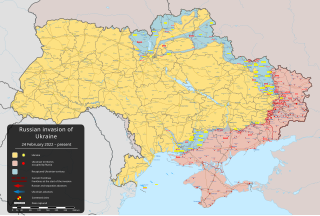
English: Russiese inval in Oekraïne, 2022 – militêre offensief wat op 24 Februarie 2022 begin, deel van die Russies-Oekraïnse Oorlog [] |
||
| Datum | 24 Februarie 2022 (first version) | ||
| Bron |
Own work based on: Russo-Ukrainian conflict (2014-2022).svg by Rr016 & Ukraine adm location map improved.svg by Yakiv Gluck
|
||
| Outeur | Viewsridge | ||
| Ander weergawes |
[]
|
||
| SVG genesis | This map is translated using SVG switch elements: all translations are stored in the same file.
|


.gif)

.gif)


_en.png)
_vi.png)
_ru.png)
.svg)
This file is translated using SVG <switch> elements. All translations are stored in the same file! Learn more.
For most Wikipedia projects, you can embed the file normally (without a To translate the text into your language, you can use the SVG Translate tool. Alternatively, you can download the file to your computer, add your translations using whatever software you're familiar with, and re-upload it with the same name. You will find help in Graphics Lab if you're not sure how to do this. |
Lisensiëring
- U is vry:
- om te deel – die werk kopieer, versprei en deurgee
- om te hermeng – om die werk aan te pas
- Onder die volgende voorwaardes:
- naamsvermelding – U moet die nodige krediet gee, 'n skakel na die lisensie verskaf en aandui of daar veranderinge aangebring is. U mag dit op enige redelike manier doen, maar nie op enige manier wat daarop dui dat die lisensiegewer u of u gebruik onderskryf nie.
- insgelyks – As u die materiaal hermix, transformeer of voortbou, moet u u bydraes versprei onder die dieselfde of versoenbare lisensie as die oorspronklike.
Lêergeskiedenis
Klik op die datum/tyd om te sien hoe die lêer destyds gelyk het.
| Datum/Tyd | Duimnael | Dimensies | Gebruiker | Opmerking | |
|---|---|---|---|---|---|
| huidig | 04:45, 9 Mei 2024 | | 2 199 × 1 478 (3,7 MG) | Physeters | Updates per the ISW; add Ocheretyne |
| 19:22, 8 Mei 2024 |  | 2 199 × 1 478 (3,7 MG) | Alexiscoutinho | Updated Kyslivka per detailed map | |
| 16:32, 6 Mei 2024 |  | 2 199 × 1 478 (3,7 MG) | Alexiscoutinho | Updated Vuhledar per detailed map | |
| 05:50, 6 Mei 2024 |  | 2 199 × 1 478 (3,7 MG) | Physeters | Updates north of Avdiivka per the ISW | |
| 00:17, 1 Mei 2024 |  | 2 199 × 1 478 (3,7 MG) | Physeters | Updates across the front per the ISW | |
| 23:30, 30 April 2024 |  | 2 199 × 1 478 (3,7 MG) | Alexiscoutinho | Updated Kyslivka & Pervomaiske per Territorial control page | |
| 06:02, 24 April 2024 |  | 2 199 × 1 478 (3,7 MG) | Physeters | Small updates per the ISW; update Novmykhailivka & Heorhiivka per the ISW | |
| 09:11, 21 April 2024 |  | 2 199 × 1 478 (3,7 MG) | Physeters | Updates per the ISW; mark Krasnohorivka & Bilohorivka as contested per the ISW | |
| 07:00, 17 April 2024 |  | 2 199 × 1 478 (3,7 MG) | Physeters | Small updates per the ISW | |
| 07:38, 8 April 2024 |  | 2 199 × 1 478 (3,7 MG) | Physeters | Small updates per the ISW; add Synkivka, Kyslivka, Novoiehorivka, Terny, Heorhiivka, and Novomykhailivka |
Lêergebruik
Die volgende bladsy gebruik dié lêer:
Globale lêergebruik
Die volgende ander wiki's gebruik hierdie lêer:
- Gebruik in als.wikipedia.org
- Gebruik in am.wikipedia.org
- Gebruik in ang.wikipedia.org
- Gebruik in an.wikipedia.org
- Gebruik in ar.wikipedia.org
- Gebruik in ary.wikipedia.org
- Gebruik in arz.wikipedia.org
- Gebruik in ast.wikipedia.org
- Gebruik in azb.wikipedia.org
- Gebruik in az.wikipedia.org
- Gebruik in bat-smg.wikipedia.org
- Gebruik in bcl.wikipedia.org
- Gebruik in be-tarask.wikipedia.org
- Gebruik in be.wikipedia.org
- Gebruik in bg.wikipedia.org
- Gebruik in bh.wikipedia.org
- Gebruik in bn.wikipedia.org
- Gebruik in br.wikipedia.org
- Gebruik in bs.wikipedia.org
- Gebruik in bxr.wikipedia.org
- Gebruik in ca.wikipedia.org
Wys meer globale gebruik van die lêer.