
Lêer:Autonomous Region Kurdistan-en.png
Grootte van hierdie voorskou: 581 × 599 piksels. Ander resolusies: 233 × 240 piksels | 465 × 480 piksels | 1 012 × 1 044 piksels.
Oorspronklike lêer (1 012 × 1 044 piksels, lêergrootte: 514 KG, MIME-tipe: image/png)
Opsomming
| Beskrywing |
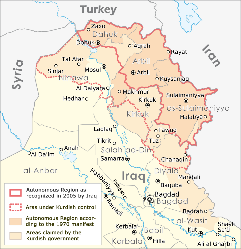
English: Map of the Autonomous Region Kurdistan, created by Maximilian Dörrbecker,
translated into English by ilyacadiz |
| Datum | |
| Bron | Autonome Region Kurdistan (Karte).png |
| Outeur |
Maximilian Dörrbecker (Chumwa), derviative work by ilyacadiz |
| Ander weergawes |
|
.png)
Lisensiëring
Hierdie lêer is gelisensieer onder die Creative Commons Erkenning-Insgelyks Deel 3.0 Onoorgedraagde lisensie.
- U is vry:
- om te deel – die werk kopieer, versprei en deurgee
- om te hermeng – om die werk aan te pas
- Onder die volgende voorwaardes:
- naamsvermelding – U moet die nodige krediet gee, 'n skakel na die lisensie verskaf en aandui of daar veranderinge aangebring is. U mag dit op enige redelike manier doen, maar nie op enige manier wat daarop dui dat die lisensiegewer u of u gebruik onderskryf nie.
- insgelyks – As u die materiaal hermix, transformeer of voortbou, moet u u bydraes versprei onder die dieselfde of versoenbare lisensie as die oorspronklike.
Lêergeskiedenis
Klik op die datum/tyd om te sien hoe die lêer destyds gelyk het.
| Datum/Tyd | Duimnael | Dimensies | Gebruiker | Opmerking | |
|---|---|---|---|---|---|
| huidig | 11:02, 20 Oktober 2017 | | 1 012 × 1 044 (514 KG) | Rob984 | The southern part of the Kifri district was not incorporated. The northern part in the Sulaymaniyah Governorate was, which may be the reason for the confusions (there is effectively two "Kifri districts") |
| 17:37, 14 Oktober 2008 |  | 1 012 × 1 044 (535 KG) | Ilyacadiz | {{Information |Description={{en|1=Map of the Autonomous Region Kurdistan, created by Maximilian Dörrbecker, translated into English by ilyacadiz }} |Source=Image:Autonome Region Kurdistan (Karte).png |Author=Maximilian Dörrbecker (Chumwa) |Date=October |
Lêergebruik
Die volgende bladsy gebruik dié lêer:
Globale lêergebruik
Die volgende ander wiki's gebruik hierdie lêer:
- Gebruik in ca.wikipedia.org
- Gebruik in ckb.wikipedia.org
- Gebruik in en.wikipedia.org
- Gebruik in fa.wikipedia.org
- Gebruik in fr.wikipedia.org
- Gebruik in he.wikipedia.org
- Gebruik in hr.wikipedia.org
- Gebruik in it.wikipedia.org
- Gebruik in ku.wikipedia.org
- Gebruik in nl.wikipedia.org
- Gebruik in no.wikipedia.org
- Gebruik in sh.wikipedia.org
- Gebruik in sr.wikipedia.org