
Lêer:Bangladesh divisions english.png
Grootte van hierdie voorskou: 439 × 599 piksels. Ander resolusies: 176 × 240 piksels | 500 × 682 piksels.
Oorspronklike lêer (500 × 682 piksels, lêergrootte: 19 KG, MIME-tipe: image/png)
Opsomming
| Beskrywing |
Español: Divisiones de Bangladesh
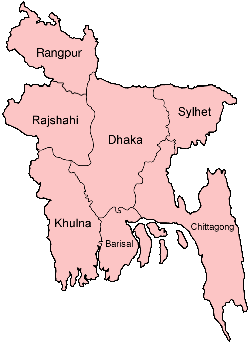
Map of the divisions of Bangladesh in English. Made by User:Golbez. |
| Datum | 31 Desember 2005 (original upload date) |
| Bron | Geen machineleesbare bron opgegeven. Eigen werk aangenomen (gebaseerd op auteursrechtclaims). |
| Outeur | Geen machineleesbare auteur aanwezig. Op basis van auteursrechtclaims wordt auteur Golbez aangenomen. |
derivative works
Derivative works of this file: Bangladesh location map-Rangpur Division.svg
Lisensiëring
Ek, die outeursreghouer van hierdie werk, publiseer dit onder die volgende lisensie:

|
Toestemming word verleen tot die kopiëring, verspreiding en/of wysiging van hierdie dokument onder die voorwaardes van die GNU-lisensie vir vrye dokumentasie, weergawe 1.2 of enige latere weergawe uitgegee deur die Stigting vir Vrye Sagteware, sonder Invariante Dele, geen Voorbladtekste en geen Agterbladtekste. 'n Kopie van hierdie lisensie is ingesluit in die afdeling getiteld GNU Free Documentation License. |
| Hierdie lêer is gelisensieer onder die Creative Commons Erkenning-Insgelyks Deel 3.0 Onoorgedraagde lisensie. | ||
| ||
| This licensing tag was added to this file as part of the GFDL licensing update. |
This file is licensed under the Creative Commons Attribution 2.5 Generic license.
- U is vry:
- om te deel – die werk kopieer, versprei en deurgee
- om te hermeng – om die werk aan te pas
- Onder die volgende voorwaardes:
- naamsvermelding – U moet die nodige krediet gee, 'n skakel na die lisensie verskaf en aandui of daar veranderinge aangebring is. U mag dit op enige redelike manier doen, maar nie op enige manier wat daarop dui dat die lisensiegewer u of u gebruik onderskryf nie.
U kan die lisensie van u keuse kies.
Lêergeskiedenis
Klik op die datum/tyd om te sien hoe die lêer destyds gelyk het.
| Datum/Tyd | Duimnael | Dimensies | Gebruiker | Opmerking | |
|---|---|---|---|---|---|
| huidig | 19:40, 27 Januarie 2010 | | 500 × 682 (19 KG) | NordNordWest | update Rangpur |
| 00:28, 1 Maart 2009 |  | 500 × 682 (19 KG) | Mahahahaneapneap | Compressed | |
| 02:52, 31 Desember 2005 |  | 500 × 682 (20 KG) | Golbez | Map of the divisions of Bangladesh in English. Made by User:Golbez. Category:Maps of Bangladesh |
Lêergebruik
Daar is geen bladsye wat dié lêer gebruik nie.
Globale lêergebruik
Die volgende ander wiki's gebruik hierdie lêer:
- Gebruik in ar.wikipedia.org
- Gebruik in ast.wikipedia.org
- Gebruik in ca.wikipedia.org
- Gebruik in de.wikipedia.org
- Gebruik in en.wikipedia.org
- Wikipedia:WikiProject Bangladesh
- Wikipedia:WikiProject Bangladesh/History Workgroup
- User:Jonny-mt/Gallery of current first-level administrative country subdivisions maps
- Wikipedia:WikiProject Bangladesh/Geography Workgroup
- Talk:Bangladesh/Archive 3
- Wikipedia:WikiProject Bangladesh/ResourcesBangladesh
- Wikipedia:Graphics Lab/Map workshop/Archive/Aug 2010
- Gebruik in eo.wikipedia.org
- Gebruik in fi.wikipedia.org
- Gebruik in fr.wikipedia.org
- Gebruik in gl.wikipedia.org
- Gebruik in hi.wikipedia.org
- बांग्लादेश
- सिलहट विभाग
- चट्टग्राम विभाग
- ढाका जिला
- ढाका विभाग
- राजशाही विभाग
- खुलना विभाग
- बरिशाल विभाग
- नरसिंगडी जिला
- मानिकगंज जिला
- मुंशीगंज जिला
- नारायनगंज जिला
- मैमनसिंह जिला
- शेरपुर जिला
- जमालपुर जिला
- नेत्रोकोना जिला
- गाजीपुर जिला (बांग्लादेश)
- किशोरगंज जिला
- टंगाइल जिला
- फरीदपुर जिला
- मदारीपुर जिला
- शरियतपुर जिला
- राजबाड़ी जिला
- बगेरहाट जिला
- चौडांगा जिला
- येशोर जिला
- झेनईदह जिला
- खुलना जिला
- कुश्तिया जिला
- मगुरा जिला
- मेहरपुर जिला
Wys meer globale gebruik van die lêer.