
Lêer:Likely routes of early rice transfer, and possible language family homelands (archaeological sites in China and SE Asia shown).png

Grootte van hierdie voorskou: 762 × 599 piksels. Ander resolusies: 305 × 240 piksels | 611 × 480 piksels | 977 × 768 piksels | 1 280 × 1 007 piksels | 2 294 × 1 804 piksels.
Oorspronklike lêer (2 294 × 1 804 piksels, lêergrootte: 1,27 MG, MIME-tipe: image/png)
.png)

|
This map image could be re-created using vector graphics as an SVG file. This has several advantages; see Commons:Media for cleanup for more information. If an SVG form of this image is available, please upload it and afterwards replace this template with
{{vector version available|new image name}}.
It is recommended to name the SVG file “Likely routes of early rice transfer, and possible language family homelands (archaeological sites in China and SE Asia shown).svg”—then the template Vector version available (or Vva) does not need the new image name parameter. |
Opsomming
| Beskrywing |
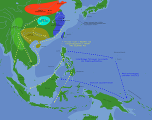
English: Likely routes of early rice transfer, and possible language family homelands (archaeological sites in China and SE Asia shown)
per: Bellwood, Peter (9 December 2011). "The Checkered Prehistory of Rice Movement Southwards as a Domesticated Cereal—from the Yangzi to the Equator" (PDF). Rice. 4 (3–4): 93–103. doi:10.1007/s12284-011-9068-9 Based on File:Blank map world rivers.svg by User:丁志仁 |
| Datum | |
| Bron | Eie werk |
| Outeur | Obsidian Soul |
Lisensiëring
Ek, die outeursreghouer van hierdie werk, publiseer dit onder die volgende lisensie:
| This file is made available under the Creative Commons CC0 1.0 Universal Public Domain Dedication. | |
| The person who associated a work with this deed has dedicated the work to the public domain by waiving all of their rights to the work worldwide under copyright law, including all related and neighboring rights, to the extent allowed by law. You can copy, modify, distribute and perform the work, even for commercial purposes, all without asking permission.
|
Lêergeskiedenis
Klik op die datum/tyd om te sien hoe die lêer destyds gelyk het.
| Datum/Tyd | Duimnael | Dimensies | Gebruiker | Opmerking | |
|---|---|---|---|---|---|
| huidig | 08:12, 24 Januarie 2019 | | 2 294 × 1 804 (1,27 MG) | Obsidian Soul | User created page with UploadWizard |
Lêergebruik
Die volgende bladsy gebruik dié lêer:
Globale lêergebruik
Die volgende ander wiki's gebruik hierdie lêer:
- Gebruik in el.wikipedia.org
- Gebruik in en.wikipedia.org
- Gebruik in es.wikipedia.org
- Gebruik in fr.wikipedia.org
- Gebruik in he.wikipedia.org
- Gebruik in id.wikipedia.org
- Gebruik in it.wikipedia.org
- Gebruik in nl.wikipedia.org
- Gebruik in vi.wikipedia.org
- Gebruik in zh.wikipedia.org
.png)