
Lêer:Map-of-southeast-asia 1000 - 1100 CE.png

Grootte van hierdie voorskou: 426 × 600 piksels. Ander resolusies: 170 × 240 piksels | 341 × 480 piksels | 791 × 1 114 piksels.
Oorspronklike lêer (791 × 1 114 piksels, lêergrootte: 162 KG, MIME-tipe: image/png)
3ㅐㅛㅑ혀댜해ㅔㅎ재ㅗ3ㅐㅗ39햐3호9ㅍ뎌ㅗㅑㅑㄷ
Opsomming
| Beskrywing |
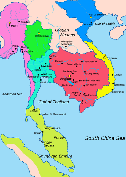
English: Map of Mainland Southeast Asia circa 1000 - 1100 CE, showing Khmer Empire in red, Lavo kingdom/Dvaravati in light blue, Haripunjaya in green, Champa in yellow, Dai Viet in blue, Kingdom of Pagan in pink, Srivijaya in lime and surrounding states.
sources http://ecaimaps.berkeley.edu/animations/2003_03_khmer_animation.swf http://www.britannica.com/EBchecked/media/3395/Khmer-empire-1200 Atlas of world history, Patrick Karl O'brien Societies, Networks, and Transitions: A Global History, Volume B. Craig A.Lockard http://upload.wikimedia.org/wikipedia/commons/thumb/4/45/Srivijaya_Empire.svg/2000px-Srivijaya_Empire.svg.png File:DvaravatiMapThailand.png http://upload.wikimedia.org/wikipedia/commons/e/eb/Thailand_2002_CIA_map.jpg |
| Datum | |
| Bron | Eie werk |
| Outeur | Javierfv1212 |
Lisensiëring
Ek, die outeursreghouer van hierdie werk, publiseer dit onder die volgende lisensie:
| This file is made available under the Creative Commons CC0 1.0 Universal Public Domain Dedication. | |
| The person who associated a work with this deed has dedicated the work to the public domain by waiving all of their rights to the work worldwide under copyright law, including all related and neighboring rights, to the extent allowed by law. You can copy, modify, distribute and perform the work, even for commercial purposes, all without asking permission.
|

|
This historical map image could be re-created using vector graphics as an SVG file. This has several advantages; see Commons:Media for cleanup for more information. If an SVG form of this image is available, please upload it and afterwards replace this template with
{{vector version available|new image name}}.
It is recommended to name the SVG file “Map-of-southeast-asia 1000 - 1100 CE.svg”—then the template Vector version available (or Vva) does not need the new image name parameter. |
Lêergeskiedenis
Klik op die datum/tyd om te sien hoe die lêer destyds gelyk het.
| Datum/Tyd | Duimnael | Dimensies | Gebruiker | Opmerking | |
|---|---|---|---|---|---|
| huidig | 21:57, 19 Julie 2011 | | 791 × 1 114 (162 KG) | Ras67 | cropped |
| 02:18, 28 Maart 2011 |  | 800 × 1 125 (224 KG) | Javierfv1212 | {{Information |Description ={{en|1=Map of Southeast Asia circa 1000 - 1100 CE, showing Khmer Empire in red, Lavo kingdom/Dvaravati in light blue, Haripunjaya in green, Champa in yellow and surrounding states. sources http://ecaimaps.berkeley.edu/an |
Lêergebruik
Die volgende bladsy gebruik dié lêer:
Globale lêergebruik
Die volgende ander wiki's gebruik hierdie lêer:
- Gebruik in ar.wikipedia.org
- Gebruik in ast.wikipedia.org
- Gebruik in ba.wikipedia.org
- Gebruik in bn.wikipedia.org
- Gebruik in ca.wikipedia.org
- Gebruik in de.wikipedia.org
- Gebruik in el.wikipedia.org
- Gebruik in en.wikipedia.org
- Gebruik in eu.wikipedia.org
- Gebruik in fr.wikipedia.org
- Gebruik in gl.wikipedia.org
- Gebruik in hi.wikipedia.org
- Gebruik in id.wikipedia.org
- Gebruik in incubator.wikimedia.org
- Gebruik in it.wikipedia.org
- Gebruik in ja.wikipedia.org
- Gebruik in km.wikipedia.org
- Gebruik in ko.wikipedia.org
- Gebruik in lfn.wikipedia.org
- Gebruik in lt.wikipedia.org
- Gebruik in ml.wikipedia.org
- Gebruik in mn.wikipedia.org
- Gebruik in no.wikipedia.org
- Gebruik in pt.wikipedia.org
- Gebruik in ru.wikipedia.org
- Gebruik in sh.wikipedia.org
- Gebruik in sl.wikipedia.org
- Gebruik in th.wikipedia.org
- Gebruik in uk.wikipedia.org
Wys meer globale gebruik van die lêer.