
Lêer:Map of the provinces of South Africa 1910-1976 with English labels.svg

Size of this PNG preview of this SVG file: 684 × 599 piksels. Ander resolusies: 274 × 240 piksels | 548 × 480 piksels | 876 × 768 piksels | 1 168 × 1 024 piksels | 2 337 × 2 048 piksels | 809 × 709 piksels.
Oorspronklike lêer (SVG-lêer, normaalweg 809 × 709 piksels, lêergrootte: 393 KG)
Opsomming
| Beskrywing |
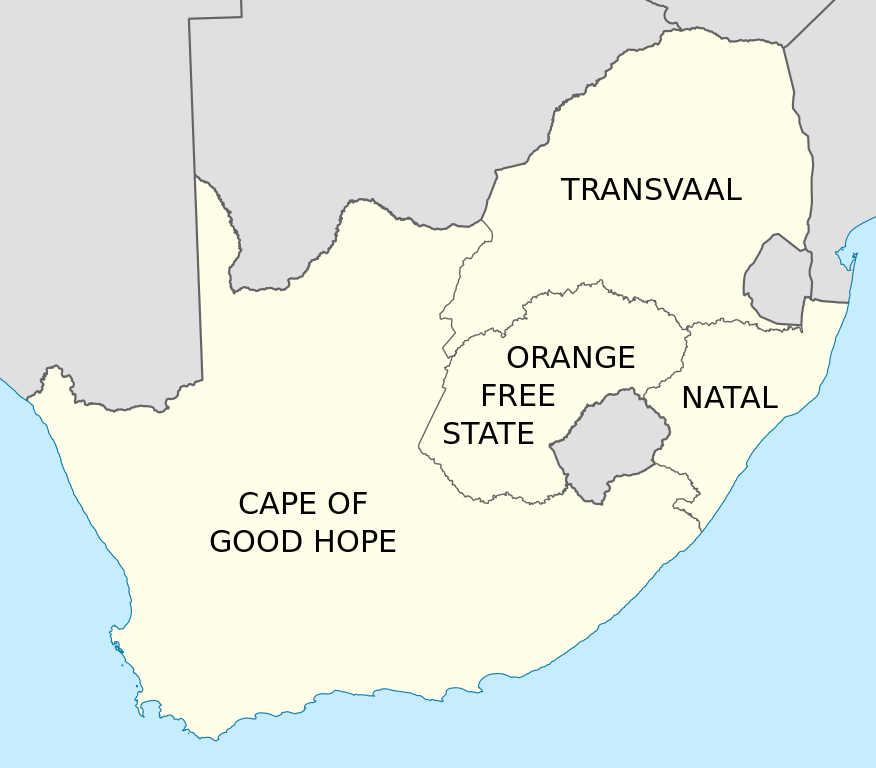
English: Map of South Africa showing the provinces as they were from 1910 to 1976, with labels in English. Based on File:Map of South Africa with provincial borders 1910-1976.svg. |
| Datum | |
| Bron | Eie werk |
| Outeur | Htonl |
| Ander weergawes | File:Map of South Africa with provincial borders 1910-1976.svg, File:Kaart van die provinsies van Suid-Afrika 1910-1976 met Afrikaanse byskrifte.svg |
Lisensiëring
Ek, die outeursreghouer van hierdie werk, publiseer dit onder die volgende lisensie:
Hierdie lêer is gelisensieer onder die Creative Commons Erkenning-Insgelyks Deel 3.0 Onoorgedraagde lisensie.
- U is vry:
- om te deel – die werk kopieer, versprei en deurgee
- om te hermeng – om die werk aan te pas
- Onder die volgende voorwaardes:
- naamsvermelding – U moet die nodige krediet gee, 'n skakel na die lisensie verskaf en aandui of daar veranderinge aangebring is. U mag dit op enige redelike manier doen, maar nie op enige manier wat daarop dui dat die lisensiegewer u of u gebruik onderskryf nie.
- insgelyks – As u die materiaal hermix, transformeer of voortbou, moet u u bydraes versprei onder die dieselfde of versoenbare lisensie as die oorspronklike.

|
Toestemming word verleen tot die kopiëring, verspreiding en/of wysiging van hierdie dokument onder die voorwaardes van die GNU-lisensie vir vrye dokumentasie, weergawe 1.2 of enige latere weergawe uitgegee deur die Stigting vir Vrye Sagteware, sonder Invariante Dele, geen Voorbladtekste en geen Agterbladtekste. 'n Kopie van hierdie lisensie is ingesluit in die afdeling getiteld GNU Free Documentation License. |
U kan die lisensie van u keuse kies.
Lêergeskiedenis
Klik op die datum/tyd om te sien hoe die lêer destyds gelyk het.
| Datum/Tyd | Duimnael | Dimensies | Gebruiker | Opmerking | |
|---|---|---|---|---|---|
| huidig | 21:55, 7 Maart 2011 | | 809 × 709 (393 KG) | Htonl | == Summary == {{Information |Description ={{en|1=Map of South Africa showing the provinces as they were from 1910 to 1976, with labels in English. Based on File:Map of South Africa with provincial borders 1910-1976.svg.}} |Source ={{own}} |
Lêergebruik
Die volgende bladsy gebruik dié lêer:
Globale lêergebruik
Die volgende ander wiki's gebruik hierdie lêer:
- Gebruik in ar.wikipedia.org
- Gebruik in ast.wikipedia.org
- Gebruik in azb.wikipedia.org
- Gebruik in bn.wikipedia.org
- Gebruik in ca.wikipedia.org
- Gebruik in de.wikipedia.org
- Gebruik in en.wikipedia.org
- Gebruik in es.wikipedia.org
- Gebruik in id.wikipedia.org
- Gebruik in it.wikipedia.org
- Gebruik in ml.wikipedia.org
- Gebruik in ms.wikipedia.org
- Gebruik in nl.wikipedia.org
- Gebruik in pl.wikipedia.org
- Gebruik in ro.wikipedia.org
- Gebruik in sl.wikipedia.org
- Gebruik in sw.wikipedia.org
- Gebruik in th.wikipedia.org
- Gebruik in tn.wikipedia.org
- Gebruik in tr.wikipedia.org
- Gebruik in uk.wikipedia.org
- Gebruik in zh.wikipedia.org