
Lêer:Population densities in Spain (2007).svg

Size of this PNG preview of this SVG file: 568 × 387 piksels. Ander resolusies: 320 × 218 piksels | 640 × 436 piksels | 1 024 × 698 piksels | 1 280 × 872 piksels | 2 560 × 1 744 piksels.
Oorspronklike lêer (SVG-lêer, normaalweg 568 × 387 piksels, lêergrootte: 1,5 MG)
.svg)
Opsomming
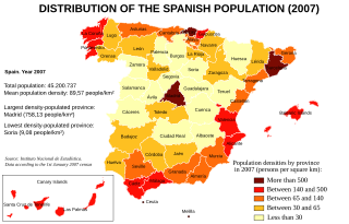
| Beskrywing | Map of Spain showing the population densities by province, according to the 1st January 2007 Instituto Nacional de Estadística census. |
| Datum | |
| Bron | Instituto Nacional de Estadística de España [1]. |
| Outeur | Created by Rodriguillo, from Image:Provinces of Spain.svg, created by Emilio Gómez Fernández |
| Ander weergawes | Image:Densidades de población en España (2007).svg (in Spanish) |
.svg)
Lisensiëring
| This work has been released into the public domain by its author, Rodriguillo. This applies worldwide. In sommige lande is dit dalk nie wettiglik moontlik nie. Indien so: |
Lêergeskiedenis
Klik op die datum/tyd om te sien hoe die lêer destyds gelyk het.
| Datum/Tyd | Duimnael | Dimensies | Gebruiker | Opmerking | |
|---|---|---|---|---|---|
| huidig | 16:29, 6 Februarie 2008 | | 568 × 387 (1,5 MG) | Rodriguillo | == Summary == {{Information |Description= Map of Spain showing the population densities by province, according to the 1st January 2007 ''Instituto Nacional de Estadística'' census. |Source= Instituto Nacional de Estadística de España [http://www.ine.e |
Lêergebruik
Die volgende bladsy gebruik dié lêer:
Globale lêergebruik
Die volgende ander wiki's gebruik hierdie lêer:
- Gebruik in bg.wikipedia.org
- Gebruik in cs.wikipedia.org
- Gebruik in en.wikipedia.org
- Gebruik in zh.wikipedia.org
.svg)