
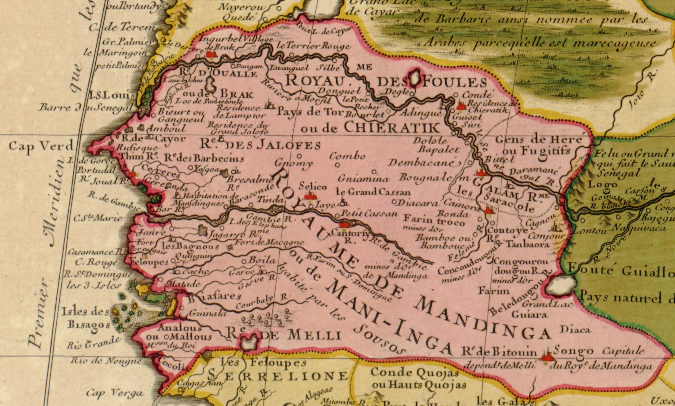
Lêer:Guillaume Delisle Senegambia 1707.jpg
Grootte van hierdie voorskou: 800 × 482 piksels. Ander resolusies: 320 × 193 piksels | 640 × 385 piksels | 1 024 × 617 piksels | 1 280 × 771 piksels | 2 200 × 1 325 piksels.
Oorspronklike lêer (2 200 × 1 325 piksels, lêergrootte: 784 KG, MIME-tipe: image/jpeg)
Opsomming
| Beskrywing |
English: Part of North West Africa (original title: Carte de la Barbarie de la Nigritie et de La Guinee; it translates: "Map of the Barbary of Nigritie & Guinea") |
|||||||||||||||||||||||
| Datum | C.E.1707/H.E.11,707 | |||||||||||||||||||||||
| Bron |
Library of Congress Geography & Map Division; Call Number G8220 1707 .L5
|
|||||||||||||||||||||||
| Outeur |
|
|||||||||||||||||||||||
| Ander weergawes | full map: File:Guillaume_Delisle_North_West_Africa_1707.jpg | |||||||||||||||||||||||


Lisensiëring
|
This work is in the public domain in its country of origin and other countries and areas where the copyright term is the author's life plus 100 years or fewer. | |
| Hierdie lêer is geïdentifiseer as vry van bekende beperkings onder kopiereg, insluitend alle verwante en naburige regte. | |
Lêergeskiedenis
Klik op die datum/tyd om te sien hoe die lêer destyds gelyk het.
| Datum/Tyd | Duimnael | Dimensies | Gebruiker | Opmerking | |
|---|---|---|---|---|---|
| huidig | 12:42, 3 Junie 2006 | | 2 200 × 1 325 (784 KG) | Ephraim33 | {{Information| |Description=Part of North West Africa (original title: Carte de la Barbarie de la Nigritie et de La Guinee) |Source=http://memory.loc.gov/cgi-bin/map_item.pl?data=/home/www/data/gmd/gmd8/g8220/g8220/ct001447.jp2&itemLink=D?gmd:12:./temp/~a |
Lêergebruik
Die volgende bladsy gebruik dié lêer:
Globale lêergebruik
Die volgende ander wiki's gebruik hierdie lêer:
- Gebruik in als.wikipedia.org
- Gebruik in an.wikipedia.org
- Gebruik in ar.wikipedia.org
- Gebruik in ast.wikipedia.org
- Gebruik in be.wikipedia.org
- Gebruik in ca.wikipedia.org
- Gebruik in de.wikipedia.org
- Gebruik in en.wikipedia.org
- Gebruik in es.wikipedia.org
- Gebruik in eu.wikipedia.org
- Gebruik in fi.wikipedia.org
- Gebruik in frr.wikipedia.org
- Gebruik in fr.wikipedia.org
- Gebruik in gl.wikipedia.org
- Gebruik in ha.wikipedia.org
- Gebruik in io.wikipedia.org
- Gebruik in it.wikipedia.org
- Gebruik in ja.wikipedia.org
- Gebruik in ka.wikipedia.org
Wys meer globale gebruik van die lêer.