
Lêer:LocationBakerIsland.png
Geen hoër resolusie is beskikbaar nie.
LocationBakerIsland.png (250 × 158 piksels, lêergrootte: 6 KG, MIME-tipe: image/png)
Opsomming
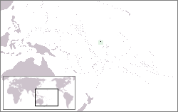
| Beskrywing | Map of the location of the Baker Island in the Pacific Ocean |
| Datum | |
| Bron | lv:Attēls:Beikera vieta.png |
| Outeur | Feens |
| Toestemming (Hergebruik van die lêer) |
GFDL, because it was in Wikipedia |
Lisensiëring

|
Toestemming word verleen tot die kopiëring, verspreiding en/of wysiging van hierdie dokument onder die voorwaardes van die GNU-lisensie vir vrye dokumentasie, weergawe 1.2 of enige latere weergawe uitgegee deur die Stigting vir Vrye Sagteware, sonder Invariante Dele, geen Voorbladtekste en geen Agterbladtekste. 'n Kopie van hierdie lisensie is ingesluit in die afdeling getiteld GNU Free Documentation License. |
| Hierdie lêer is gelisensieer onder die Creative Commons Erkenning-Insgelyks Deel 3.0 Onoorgedraagde lisensie. | ||
| ||
| This licensing tag was added to this file as part of the GFDL licensing update. |
Lêergeskiedenis
Klik op die datum/tyd om te sien hoe die lêer destyds gelyk het.
| Datum/Tyd | Duimnael | Dimensies | Gebruiker | Opmerking | |
|---|---|---|---|---|---|
| huidig | 00:24, 20 Julie 2006 | | 250 × 158 (6 KG) | Zeman | {{Information |Description=Map of the location of the Baker Island in the Pacific Ocean |Source=lv:Attēls:Beikera vieta.png |Date=26.1.2005 |Author=Feens |Permission=GFDL, because it was in Wikipedia |other_versions= }} |
Lêergebruik
Die volgende 2 bladsye gebruik dié lêer:
Globale lêergebruik
Die volgende ander wiki's gebruik hierdie lêer:
- Gebruik in ar.wikipedia.org
- Gebruik in arz.wikipedia.org
- Gebruik in ban.wikipedia.org
- Gebruik in bs.wikipedia.org
- Gebruik in ca.wikipedia.org
- Gebruik in ceb.wikipedia.org
- Gebruik in cs.wikipedia.org
- Gebruik in en.wikipedia.org
- Gebruik in en.wikivoyage.org
- Gebruik in gl.wikipedia.org
- Gebruik in hr.wikipedia.org
- Gebruik in ja.wikipedia.org
- Gebruik in ko.wikipedia.org
- Gebruik in lb.wikipedia.org
- Gebruik in ms.wikipedia.org
- Gebruik in my.wikipedia.org
- Gebruik in pnb.wikipedia.org
- Gebruik in uk.wikipedia.org
- Gebruik in ur.wikipedia.org
- Gebruik in www.wikidata.org
- Gebruik in zh.wikivoyage.org