
Lêer:1939-1940-battle of france-plan-evolution.jpg
Grootte van hierdie voorskou: 788 × 600 piksels. Ander resolusies: 315 × 240 piksels | 631 × 480 piksels | 1 009 × 768 piksels | 1 256 × 956 piksels.
Oorspronklike lêer (1 256 × 956 piksels, lêergrootte: 389 KG, MIME-tipe: image/jpeg)

|
This file has been superseded by 1939-1940-battle of france-plan-evolution.png. It is recommended to use the other file. Please note that deleting superseded images requires consent. Reason to use the other file: "A PNG version of this file is now available."
|

|
Opsomming
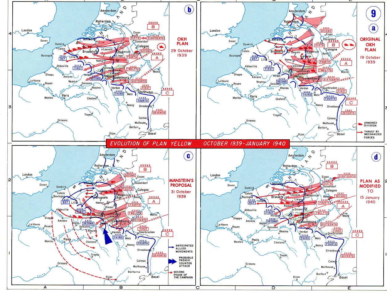
Español: Evolución del Plan Amarillo alemán
Lisensiëring
This work is in the public domain in the United States because it is a work prepared by an officer or employee of the United States Government as part of that person’s official duties under the terms of Title 17, Chapter 1, Section 105 of the US Code.
Note: This only applies to original works of the Federal Government and not to the work of any individual U.S. state, territory, commonwealth, county, municipality, or any other subdivision. This template also does not apply to postage stamp designs published by the United States Postal Service since 1978. (See § 313.6(C)(1) of Compendium of U.S. Copyright Office Practices). It also does not apply to certain US coins; see The US Mint Terms of Use.
|
 | |
| Hierdie lêer is geïdentifiseer as vry van bekende beperkings onder kopiereg, insluitend alle verwante en naburige regte. | ||
Lêergeskiedenis
Klik op die datum/tyd om te sien hoe die lêer destyds gelyk het.
| Datum/Tyd | Duimnael | Dimensies | Gebruiker | Opmerking | |
|---|---|---|---|---|---|
| huidig | 18:13, 17 Januarie 2006 | | 1 256 × 956 (389 KG) | Kingruedi~commonswiki | Source: http://www.dean.usma.edu/history/web03/atlases/ww2%20europe/ww2%20europe%20pages/ww2%20europe%20map%2009.htm en:Image:1939GermanPlanEvolution.jpg |
Lêergebruik
Die volgende bladsy gebruik dié lêer:
Globale lêergebruik
Die volgende ander wiki's gebruik hierdie lêer:
- Gebruik in an.wikipedia.org
- Gebruik in bg.wikipedia.org
- Gebruik in ca.wikipedia.org
- Gebruik in da.wikipedia.org
- Gebruik in de.wikipedia.org
- Gebruik in en.wikipedia.org
- Gebruik in es.wikipedia.org
- Gebruik in hr.wikipedia.org
- Gebruik in hu.wikipedia.org
- Gebruik in id.wikipedia.org
- Gebruik in it.wikipedia.org
- Gebruik in ja.wikipedia.org
- Gebruik in lt.wikipedia.org
- Gebruik in ms.wikipedia.org
- Gebruik in nl.wikipedia.org
- Gebruik in pl.wikipedia.org
- Gebruik in ro.wikipedia.org
- Gebruik in sh.wikipedia.org
- Gebruik in sl.wikipedia.org
- Gebruik in tr.wikipedia.org
- Gebruik in uk.wikipedia.org
- Gebruik in zh.wikipedia.org