Lêer:America noviter delineata.jpg
Page contents not supported in other languages.
in Wikipedia, die vrye ensiklopedie

Oorspronklike lêer(5 965 × 4 528 piksels, lêergrootte: 5,17 MG, MIME-tipe: image/jpeg)

Hierdie lêer kom vanaf Wikimedia Commons en kan ook in ander projekte gebruik word. Die beskrywing op die lêer se inligtingsblad word hieronder weergegee.

Opsomming

Beskrywing
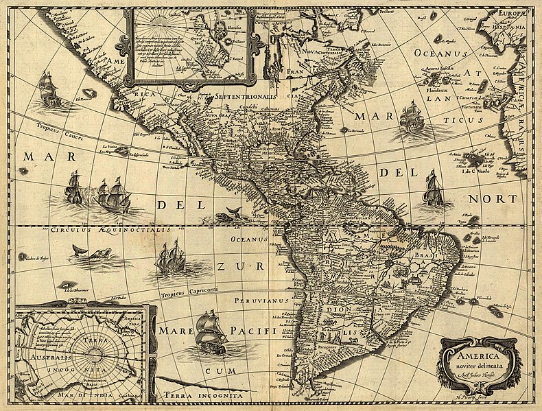
Latina: America noviter delineata / auct. Jodoco Hondio; H. Picard fecit.
English: America newly delineated / by Jodocus Hondius; engraved by H. Picard. A 17th-century map of the Americas. Scale ca. 1:45,000,000. Map ranges from W 125°–W 5° and N 70°–S 60°. Also includes insets of the polar regions.
Français : L'amérique nouvellement cartographiée / Par Jocodus Hondius; gravé par H. Picard. Une carte des amériques du XVIIe siècle. Echelle: environ 1:45 000 000. La carte couvre un espace allant de 5°W à 125°W et de 60°S à 70°N. Elle inclut aussi en encarts les régions polaires.
Bron

Published by Jean Boisseau. The U.S. Library of Congress gives the date of publication as "1640?", while another source suggests a first publication of 1637 or 1639. Digital version produced by the U.S. Library of Congress Geography and Map Division. JPEG 2000 source image converted to JPEG by User:Delirium using JasPer 1.701.0, since JPEG 2000 is not as of this uploading supported on Commons.

This map is available from the United States Library of Congress's Geography & Map Division
under the digital ID g3290.np000144.
This tag does not indicate the copyright status of the attached work. A normal copyright tag is still required. See Commons:Licensing.

العربية  беларуская (тарашкевіца)  বাংলা  čeština  Deutsch  English  español  فارسی  suomi  français  galego  עברית  magyar  Bahasa Indonesia  italiano  日本語  lietuvių  македонски  മലയാളം  Nederlands  polski  português  português do Brasil  română  русский  sicilianu  slovenčina  slovenščina  Türkçe  українська  简体中文  繁體中文  +/−

Skepper
Jodocus Hondius (1563-1612)
Toestemming
(Hergebruik van die lêer)
This is a faithful photographic reproduction of a two-dimensional, public domain work of art. The work of art itself is in the public domain for the following reason:
Public domain

This work is in the public domain in its country of origin and other countries and areas where the copyright term is the author's life plus 100 years or fewer.


You must also include a United States public domain tag to indicate why this work is in the public domain in the United States.
The official position taken by the Wikimedia Foundation is that "faithful reproductions of two-dimensional public domain works of art are public domain".
This photographic reproduction is therefore also considered to be in the public domain in the United States. In other jurisdictions, re-use of this content may be restricted; see Reuse of PD-Art photographs for details.
Georeferencing Georeference the map in Wikimaps Warper If inappropriate please set warp_status = skip to hide.


Awards

Image of the year
Image of the year
Image of the day
Image of the day
Featured image

Wikimedia Commons

This file was a candidate in Picture of the Year 2006.
This file was the picture of the day on April 17, 2007.
This is a featured picture on Wikimedia Commons (Spogbeelde) and is considered one of the finest images. See its nomination here.
 With an aspect ratio of 4:3 or 5:4, this image is suitable as a computer wallpaper (see gallery).

If you have an image of similar quality that can be published under a suitable copyright license, be sure to upload it, tag it, and nominate it.

Captions

Add a one-line explanation of what this file represents
A 17th-century map of the Americas newly delineated by Jodocus Hondius; engraved by H. Picard.

Items portrayed in this file

uitbeelding

media type Engels

image/jpeg

checksum Engels

5ad48d30d4daf7c752e21a8ff169415effca1831

data size Engels

5 422 959 greep

height Engels

4 528 pieksel

width Engels

5 965 pieksel

Lêergeskiedenis

Klik op die datum/tyd om te sien hoe die lêer destyds gelyk het.

Datum/TydDuimnaelDimensiesGebruikerOpmerking
huidig06:33, 14 Junie 2006Duimnaelskets vir weergawe vanaf 06:33, 14 Junie 20065 965 × 4 528 (5,17 MG)Delirium''America noviter delineata / auct. Jodoco Hondio; H. Picard fecit.'' (America newly delineated / by Jodoco Hondia; engraved by H. Picard.) A 17th-century map of the Americas. Scale ca. 1:45,000,000. Map ranges from W 125°–W 5° and N 70&d

Globale lêergebruik

Die volgende ander wiki's gebruik hierdie lêer:

Wys meer globale gebruik van die lêer.

Metadata