
Lêer:Bangladesh LOC 1996 map.jpg

Grootte van hierdie voorskou: 478 × 599 piksels. Ander resolusies: 191 × 240 piksels | 383 × 480 piksels | 613 × 768 piksels | 817 × 1 024 piksels | 1 596 × 2 000 piksels.
Oorspronklike lêer (1 596 × 2 000 piksels, lêergrootte: 1,5 MG, MIME-tipe: image/jpeg)
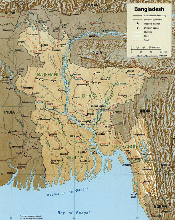
Map of Bangladesh.
http://hdl.loc.gov/loc.gmd/g7645.ct001002
This work is in the public domain in the United States because it is a work prepared by an officer or employee of the United States Government as part of that person’s official duties under the terms of Title 17, Chapter 1, Section 105 of the US Code.
Note: This only applies to original works of the Federal Government and not to the work of any individual U.S. state, territory, commonwealth, county, municipality, or any other subdivision. This template also does not apply to postage stamp designs published by the United States Postal Service since 1978. (See § 313.6(C)(1) of Compendium of U.S. Copyright Office Practices). It also does not apply to certain US coins; see The US Mint Terms of Use.
|
 | |
| Hierdie lêer is geïdentifiseer as vry van bekende beperkings onder kopiereg, insluitend alle verwante en naburige regte. | ||
Lêergeskiedenis
Klik op die datum/tyd om te sien hoe die lêer destyds gelyk het.
| Datum/Tyd | Duimnael | Dimensies | Gebruiker | Opmerking | |
|---|---|---|---|---|---|
| huidig | 19:56, 25 Oktober 2005 | | 1 596 × 2 000 (1,5 MG) | Brian0918 | Map of Bangladesh. http://hdl.loc.gov/loc.gmd/g7645.ct001002 {{PD-USGov}} Category:Maps of Bangladesh |
Lêergebruik
Daar is geen bladsye wat dié lêer gebruik nie.
Globale lêergebruik
Die volgende ander wiki's gebruik hierdie lêer:
- Gebruik in als.wikipedia.org
- Gebruik in as.wikipedia.org
- Gebruik in bg.wikipedia.org
- Gebruik in bh.wikipedia.org
- Gebruik in bn.wikipedia.org
- Gebruik in ca.wikipedia.org
- Gebruik in el.wikipedia.org
- Gebruik in en.wikipedia.org
- Gebruik in eo.wikipedia.org
- Gebruik in es.wikipedia.org
- Gebruik in fi.wikipedia.org
- Gebruik in fr.wikipedia.org
- Gebruik in gl.wikipedia.org
- Gebruik in gu.wikipedia.org
- Gebruik in hif.wikipedia.org
- Gebruik in hi.wikipedia.org
- Gebruik in hr.wiktionary.org
- Gebruik in hu.wikipedia.org
- Gebruik in id.wikipedia.org
- Gebruik in it.wikipedia.org
Wys meer globale gebruik van die lêer.