
Lêer:Battle of Colenso Map.png

Oorspronklike lêer (546 × 621 piksels, lêergrootte: 66 KG, MIME-tipe: image/png)
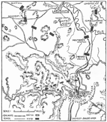
| Beskrywing | Map showing positions at the Battle of Colenso, 15 December 1899. | ||||
| Datum | |||||
| Bron | "South Africa and the Transvaal War, Vol. 2 (of 6). From the Commencement of the War to the Battle of Colenso" by Louis Creswicke. Published by T. C. & E. C. JACK EDINBURGH, 1900. Downloaded from Project Gutenberg at http://www.gutenberg.org/etext/26198 | ||||
| Outeur | Louis Creswicke | ||||
| Toestemming (Hergebruik van die lêer) |
Copyright expired.
|
||||
Lêergeskiedenis
Klik op die datum/tyd om te sien hoe die lêer destyds gelyk het.
| Datum/Tyd | Duimnael | Dimensies | Gebruiker | Opmerking | |
|---|---|---|---|---|---|
| huidig | 16:28, 30 Augustus 2008 | | 546 × 621 (66 KG) | Rcbutcher | {{Information |Description=Map showing positions at the Battle of Colenso, 15 December 1899. |Source="South Africa and the Transvaal War, Vol. 2 (of 6). From the Commencement of the War to the Battle of Colenso" by Louis Creswicke. Published by T. C. & E. |
Lêergebruik
Die volgende bladsy gebruik dié lêer:
Globale lêergebruik
Die volgende ander wiki's gebruik hierdie lêer:
- Gebruik in ca.wikipedia.org
- Gebruik in en.wikipedia.org
- Gebruik in fi.wikipedia.org
- Gebruik in fr.wikipedia.org
- Gebruik in hu.wikipedia.org
- Gebruik in nl.wikipedia.org
- Gebruik in pl.wikipedia.org
- Gebruik in ru.wikipedia.org