
Lêer:Civitas Londinium or The Agas Map of London.jpg

Grootte van hierdie voorskou: 800 × 338 piksels. Ander resolusies: 320 × 135 piksels | 640 × 271 piksels | 1 024 × 433 piksels | 1 280 × 541 piksels | 4 730 × 2 000 piksels.
Oorspronklike lêer (4 730 × 2 000 piksels, lêergrootte: 4,08 MG, MIME-tipe: image/jpeg)
Opsomming
| Beskrywing |
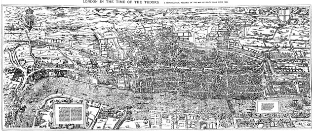
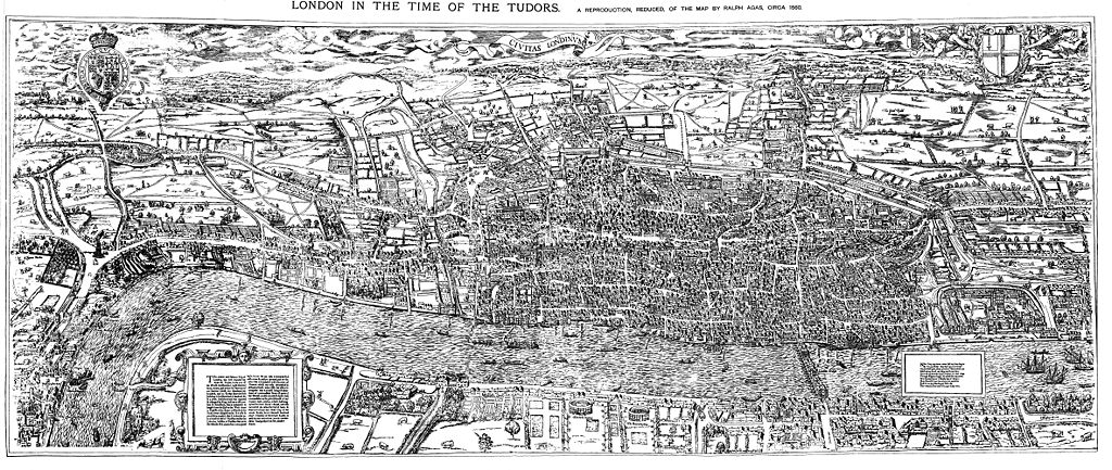
English: The earliest proper map (as opposed to panorama) of London known. Attributed to Ralph Agas, and probably surveyed between 1570 and 1605. The original was 6 foot 0.5 inches long by 2 feet 4.5 inches wide. This much reduced image is a scan of a copy of a lithograph of a copy, was itself badly repaired with sellotape and has had to be "restored"; so is hardly a truly faithful representation of the original, but few good copies exist and no other detailed public domain images are known. |
| Datum | |
| Bron | Maps of Old London, London, Adam and Charles Black, 1908. Scanned & corrected Mike Calder. |
| Outeur | Mike Calder, image of Civitas Londinium, Agas' Map of London, c. 1570-1605 |
| Ander weergawes | Derivative works of this file: Covent Garden from the Ralph Agas 1572 map of London.jpg |
Lisensiëring
|
This work is in the public domain in its country of origin and other countries and areas where the copyright term is the author's life plus 100 years or fewer. | |
| Hierdie lêer is geïdentifiseer as vry van bekende beperkings onder kopiereg, insluitend alle verwante en naburige regte. | |
Lêergeskiedenis
Klik op die datum/tyd om te sien hoe die lêer destyds gelyk het.
| Datum/Tyd | Duimnael | Dimensies | Gebruiker | Opmerking | |
|---|---|---|---|---|---|
| huidig | 18:59, 14 Augustus 2009 | | 4 730 × 2 000 (4,08 MG) | MikeCalder | {{Information |Description={{en|1=The earliest proper map (as opposed to panorama) of London known. Attributed to Ralph Agas, and probably surveyed between 1570 and 1605. The original was 6 foot 0.5 inches long by 2 feet 4.5 inches wide. This much reduc |
Lêergebruik
Die volgende bladsy gebruik dié lêer:
Globale lêergebruik
Die volgende ander wiki's gebruik hierdie lêer:
- Gebruik in ar.wikipedia.org
- Gebruik in avk.wikipedia.org
- Gebruik in azb.wikipedia.org
- Gebruik in de.wikipedia.org
- Gebruik in el.wikipedia.org
- Gebruik in en.wikipedia.org
- Gebruik in es.wikipedia.org
- Gebruik in fa.wikipedia.org
- Gebruik in hy.wikipedia.org
- Gebruik in it.wikipedia.org
- Gebruik in ja.wikipedia.org
- Gebruik in ko.wikipedia.org
- Gebruik in la.wikipedia.org
- Gebruik in pt.wikipedia.org
- Gebruik in ro.wikipedia.org
- Gebruik in ru.wikipedia.org
- Gebruik in simple.wikipedia.org
- Gebruik in sl.wikipedia.org
- Gebruik in tr.wikipedia.org
- Gebruik in uk.wikipedia.org
- Gebruik in zh.wikipedia.org